We anticipate substantial rainfall late this evening through noon tomorrow, followed by a cloudy and cool Easter, a beautiful start to the week, and a stormy following weekend. Those are your weather stories for the next 7 days.
Good morning, and welcome to Good Friday. We hope your week has been going well. We are waking up to a cloudy sky, breezy conditions, and mild temperatures, with many areas remaining above 70 degrees. This is quite unusual. However, significant weather changes are expected later today.
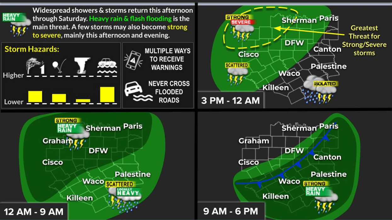
We will experience partly cloudy skies throughout most of the day, with temperatures rising to the mid-80s. This will provide fuel for the impending storms. Late this afternoon, a large area of rain with embedded thunderstorms and isolated severe storms will develop a couple of hundred miles to the west. This area of storms will form into a line and move through our region from west to east between 7:00 p.m. and midnight. One or two storms may become severe west of Denton and Fort Worth, with hail and wind being the primary threats. This area of storms will continue to slowly move across the region, producing 1 to 2 inches of rain.
After midnight, a large area of showers and storms will develop in Oklahoma along a strong cold front. This front is expected to arrive tomorrow morning, bringing heavy rain, thunder, lightning, and a threat of flash flooding. A flood watch may be issued later today for this time frame. We will continue to monitor the situation.
Morning lows will dip to near 70 degrees early, falling through the 60s during the late morning and afternoon as the rain shifts to our south after the noon hour. Rainfall totals are expected to range between 2 to 4 inches across North Texas, with isolated higher totals possible. Please stay weather-aware and avoid crossing water-covered roadways. If you encounter a flooded road, turn around and do not attempt to cross it.
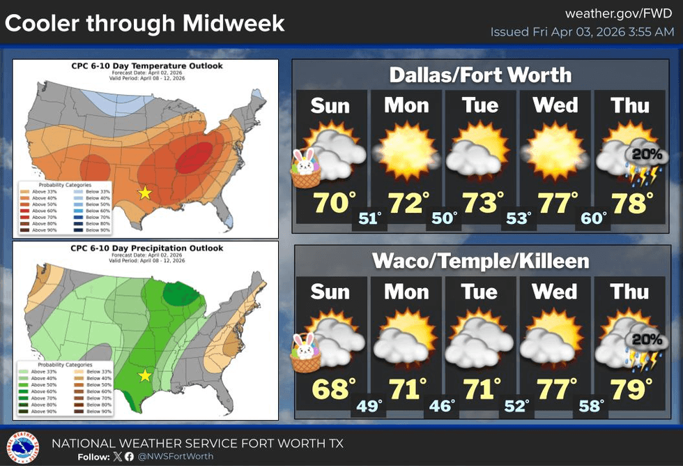
You will wake up to a cloudy sky, windy conditions, and morning lows near 50 degrees on Easter morning. Clouds will be slow to clear on Sunday, with afternoon highs in the mid-60s. The wind will relax during the day.
Skies will clear late Sunday night, giving way to a beautiful Monday and Tuesday. Morning lows will be in the upper 40s to low 50s, with afternoon highs reaching the low 70s. A slow warm-up is expected Wednesday through Friday before a stormy and wet weather pattern arrives by the end of next week and into the following weekend. It is April, and I encourage you to stay weather-aware.
Have a great Easter weekend, and enjoy the weather when you can, it's the only weather you've got.
7-Day Headlines:
- DFW Airport reached 84 yesterday. 0.56” of rain.
- OK for tailgating for opening day. A bit windy!
- Showers and strong storms arrive this evening. Isolated severe.
- Overnight heavy rain through noon Saturday.
- 2” to 4” of rain on the way. Flash flooding threat.
- MUCH cooler Saturday into Easter. Slow warm up next week.
Almanac:
- Yest Rain: 0.56”; Yest High: 84; Low: 65
- Today’s Averages: High: 74; Low: 52
- Record high: 95 (1989); Record low 30 (1987)
- April rain: 0.56”; Surplus: 0.36”
- 2026 Rain: 5.72"; Snow: 2.4” Deficit: <3.07”>
- Sunrise: 7:12am; Sunset: 7:51pm
7-Day Forecast:
- Friday: Morning clouds, afternoon sun. Breezy and warm. Isolated showers and storms, mainly east of DFW. High: Low to mid 80s. Wind: South 15-25, G30 mph.
- Friday night: Numerous showers and storms. Isolated severe early evening, west of DFW. Low: Upper 60s. Wind: South 15-25 mph.
- Saturday: Cloudy with heavy rain though late morning along a strong cold front. Staying cloudy, windy and cool. High: Upper 60s early, falling into the upper 50s in the afternoon. Wind: North 15-25 mph.
- Easter: Mostly cloudy and cool. Low: Near 50; High: Mid 60s.
- Monday and Tuesday: Partly cloudy and perfect. High: Low 70s.
- Wednesday: Partly cloudy, breezy and awesome. High: Mid 70s.
- Thursday: Partly cloudy, breezy and warmer. High: Upper 70s.