


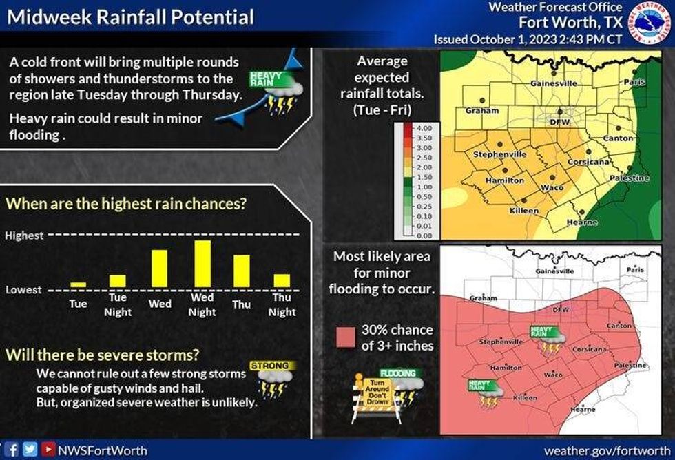
A couple more days with highs in the 90s and then much cooler weather arrives toward the end of the week. We also have decent rain chances late Wednesday into the first half of Thursday. Some areas could pick up close to 2 inches of rain.
We're starting Monday with temperatures in the 60s and 70s under a mostly clear sky. It will be sunny and warm today with highs warming back into the low 90s.
Our weather change slowly arrives on Wednesday as we now have decent rain chances Wednesday into early Thursday. As of now, I think we'll see two waves. The first wave will arrive Wednesday late morning and continue through the afternoon. Some may pick up a half inch in localized areas. The second wave arrives towards midnight Wednesday and continues through mid to late morning Thursday. This will be the heaviest rain event. Additional rainfall amounts will range from one to two with isolated higher totals.
 National Weather Service - Fort Worth
As of now, the severity looks low, but one or two storms may be severe with damaging wind being the main threat.
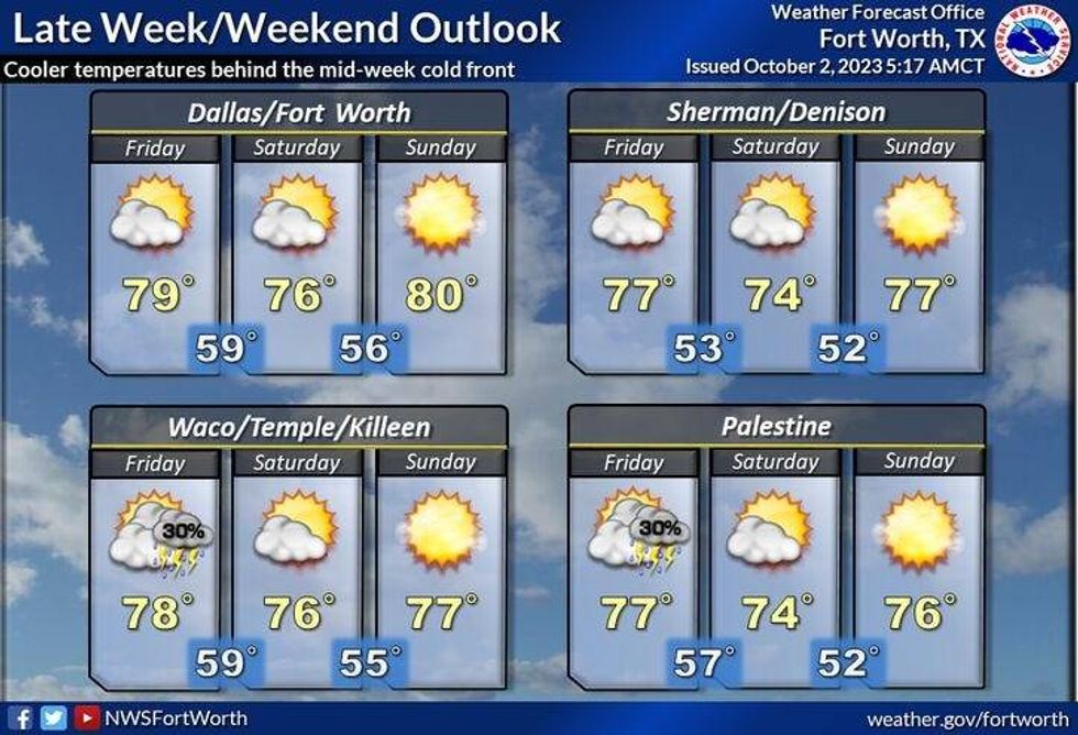
There won't be a big push of cooler air behind the first front, but due to the clouds sticking around, plus a north wind blowing on Thursday, afternoon highs will struggle to get above 80°.
 National Weather Service - Fort Worth
By late Thursday evening into Friday, a reinforcing shot of cooler/drier air will arrive. Friday will be a very breezy day with plenty of sunshine. Afternoon highs will only warm into the mid to upper 70s.
The weekend looks fantastic with plenty of sunshine, low humidity, cool mornings, and mild afternoons. Morning lows will dip into the mid-50s to low 60s... with afternoon highs between 75° and 80°.
 National Weather Service - Fort Worth
*Yest Rain: 0.00"; Yest High: 93; Low: 69
*Today's Averages: High: 84; Low: 63
*Record high: 99 (1951): Record low: 47 (1975, 1985)
*October Rain: 0.00"; Deficit: 0.10"
*2023 Rain: 15.66"; Deficit: 11.71"
*Sunrise: 7:23am; Sunset: 7:12pm
Today: Mostly sunny and warm. High: Low 90s. Wind: SE 5-10 mph.
Tonight: Fair and comfortable. Low: 68-73. Wind: SE 5-10 mph.
Tuesday: Partly cloudy, breezy, and warm. High: Low 90s. Wind: SE 10-20 mph.
Wednesday: Mostly cloudy. Scattered showers through the afternoon. Widespread showers and strong storms by late evening. High: Mid to upper 80s.
Thursday: Morning showers and storms, then scattered showers through the afternoon. Cooler. High: Upper 70s.
Friday: Sunny, windy, and cool. High: Mid to upper 70s.
Weekend: Sunny and perfect! Lows: 50s; Highs: Mid to upper 70s.
LISTEN on the Audacy App
Tell your Smart Speaker to "PLAY 1080 KRLD"
Sign Up to receive our KRLD Insider Newsletter for more news
Follow us on Facebook | Twitter | Instagram | YouTube


