Cool mornings and mild to pleasant afternoons will continue through Saturday. There's a slight chance of showers, mainly east of DFW late tonight and early tomorrow and then again on Friday. Showers and thunderstorms will be on the increase across most of north Texas this weekend, but it won't rain all of the time. Cooler temperatures are on the way Sunday through early next week as skies clear on Monday.
We're waking up to high clouds and temperatures mainly near 50° this Wednesday morning. The average low is 39 degrees so we're well above average. The average high this time of the year is 59°. We'll be well above average until we get to Sunday, that's when we'll start to cool down.
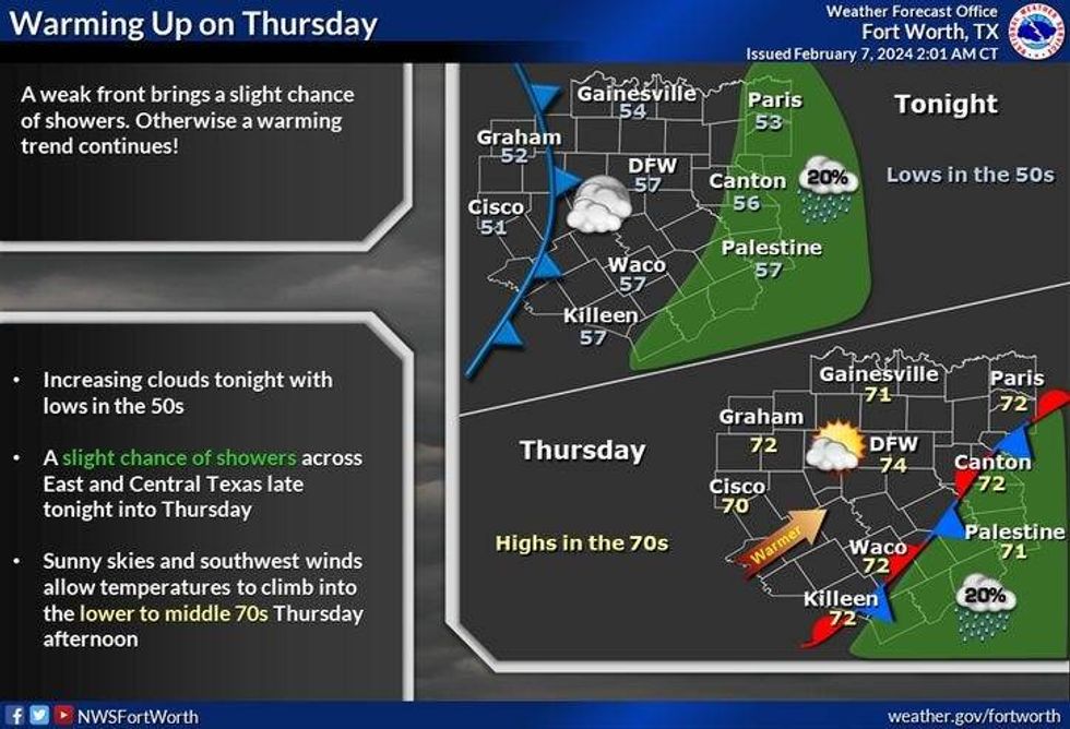
High clouds, breezy and mild today with highs in the mid to upper 60s. A south wind will gust to 25 mph. Tonight, more high clouds and a few isolated showers are possible, mainly east of DFW, ending by mid-morning tomorrow. Morning lows will drop into the mid-50s. That's it. Filtered sunshine tomorrow with highs in the low to mid-70s.
 National Weather Service - Fort Worth
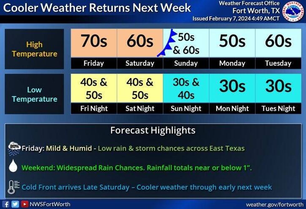
Friday looks pretty decent with increasing clouds. There will be a few showers mainly east of Dallas and Fort Worth before the end of the day. High temperatures will touch the 70° mark again.
Plan for off-and-on rain on Saturday, mainly during the first half of the day. High temperatures will reach the mid to upper 60s.
 National Weather Service - Fort Worth
A cold front and a pretty potent upper level disturbance will cross the area on Sunday. There'll be more scattered showers and maybe even a rumble of thunder around. Temperatures will start off in the upper 50s and fall into the upper 40s by evening. A north wind will gusts to 25 mph. It'll be a chilly day on Sunday. Skies will clear on Monday. Breezy and cool with highs in the mid 50s. Sunny, near 60 on Tuesday.
No Arctic air yet for North Texas, but that might change by the end of next week.
*Yest Rain: 0.00"; Yest High: 66 Low: 40
*Today's Averages: High: 59; Low: 38
*Record high: 88 (1932); Record low: 7 (1933)
*February Rain: 0.85"; Surplus: 0.38"
*2024 Rain: 4.05"; Surplus: 1.05"
*Sunrise: 7:19am; Sunset: 6:06pm
LISTEN on the Audacy App
Tell your Smart Speaker to "PLAY 1080 KRLD"
Sign Up to receive our KRLD Insider Newsletter for more news
Follow us on Facebook | Twitter | Instagram | YouTube