


Lots going on in the world of weather as we approach the end of January and enter a new month. There's not a lot going on this morning except for chilly temperatures. Readings have fallen to or slightly below freezing at this hour. A slow warm up is in store today with highs in the low to mid 50s. North winds will blow at 10 to 20 mph.
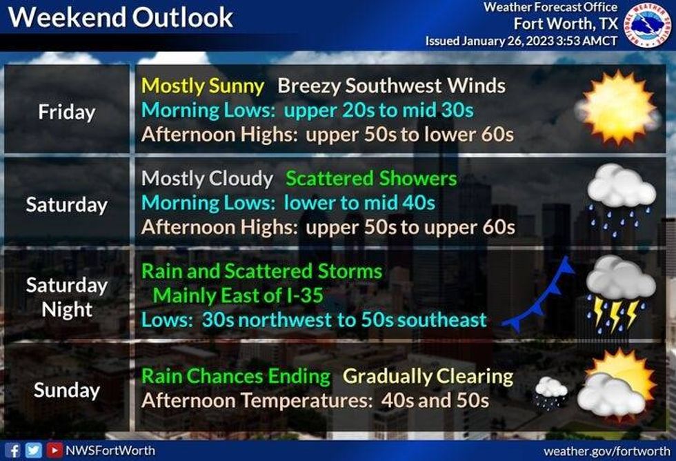
Another cold night is heading our way with readings dropping close to freezing again. Friday looks nice with highs approaching 60° with plenty of sunshine.
Clouds will rapidly increase on Saturday with a chance of a few showers by late evening into Sunday morning, especially just east and SE of DFW. Afternoon highs will reach the 60° mark again.
 National Weather Service - Fort Worth
A strong cold front will arrive by daybreak Sunday, dropping temperatures from the upper 50s early, and into the 40s during the day.... as clouds slowly decrease. The wind will gust to 30 mph, making it feel even colder.. It'll be a cold and chilly Sunday.
Next week's one of the trickiest forecasts I've had to deal with in quite some time, especially this far away from the event. A strong upper level low will dig into the desert southwest. spokes of energy will round the bottom side of this system,cruise across Texas, and cause waves of cold rain to work the way across north Texas starting Monday afternoon through early Thursday. With the cold air in place and pacific and surface moisture overrunning this cold air, this is a perfect set up for a significant rain and ice storm event. But... where will the freeze line set up? That's the $100,000 question. This question cannot be answered right now, when you're dealing with a storm system 5 to 8 days away.
Right now, I'm calling for temperatures to hover in the mid to upper 30s during the day and flirting with a freezing mark overnight. This being said, it's way too early to draw that line that will determine who will see a significant ice storm and who will just see a chilly rain. I will be keeping a close eye on the model data through the weekend into early next week.
I'd rather tell you all this now then wait until Monday or Tuesday to warn you. This gives you more time to prepare if an ice storm does happen in DFW. Please put a bug in your friends and family's ear, especially if they live along and west of a Gainesville to Mineral Wells to Stephenville line. This is where a 3-day ice storm may cripple this area and points west.
*Yest Rain: 0.00"; High: 44; Low: 37
*Today's Averages: High: 58; Low: 37
*Record high: 82 (1953); Record low: 12 (1904)
*January rain: 1.02"; Deficit: 1.06"
*2023 rain: 1.02"; Deficit: 1.06"
*Sunrise: 7:27am; Sunset: 5:55pm
Today: A chilly start. A cool end. Sunny and breezy. High: Low to mid 50s. Wind: WNW 10-20 mph.
Tonight: Clear and cold. Low: 28-34. Wind: SW 5 mph.
Friday: Sunny and cool. High: Near 60. WInd: SW 10-20 mph.
Saturday: Increasing clouds and windy. Slight chance of showers by late evening, especially east and SE of DFW. High: Near 60.
Sunday: Morning cold front with clouds. Afternoon sun. Turning colder. VERY windy. High: Mid 50s early, falling into the 40s through the day.
Monday - Wednesday: Cloudy and cold. Waves of chilly rain. Possible Ice storm to the west and NW of DFW. **DFW AREA NEEDS TO WATCH THE TEMPERATURES IN DFW STARTING LATE TUESDAY NIGHT**. High: Mid to upper 30s.

LISTEN on the Audacy App
Tell your Smart Speaker to "PLAY 1080 KRLD"
Sign Up and Follow NewsRadio 1080 KRLD


