


UPDATE 8:45 PM: The Tornado Warning has been canceled for portions of Tarrant County. Hail-producing thunderstorms continue.
UPDATE 8:22 PM: A Tornado Warning was issued for portions of Tarrant County located near Lake Worth, moving 30 MPH to the east.
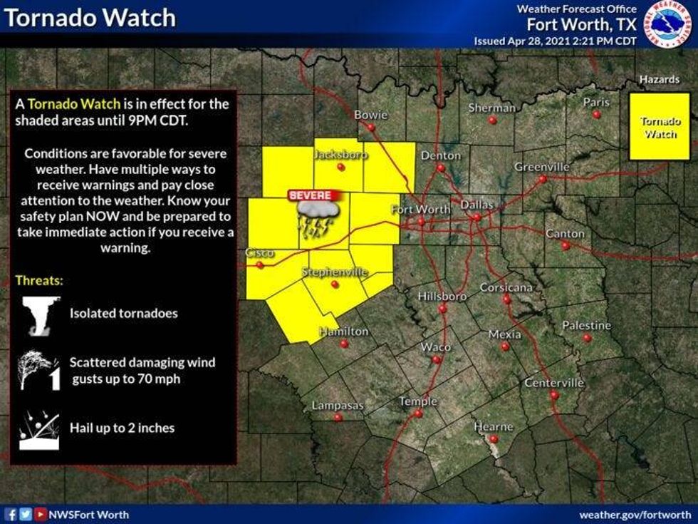
UPDATE 3:04 PM: A Tornado Watch is in effect just West of DFW at this time. This area will most likely be pushed eastward by this evening which will include all of DFW.
 NWS
NWS
The next 36 hours will be very active across all of north Texas! Please stay weather aware starting this afternoon through noon tomorrow.
North Texas has now been upgraded to a level 3 or enhanced risk for large hail, damaging wind, and tornadoes.
Scattered to numerous severe thunderstorms will start the break out as the day wears on. All facets as severe weather are possible. That means, large hail, damaging wind, and isolated tornadoes. There will be some type of watch box issued by the afternoon. It still yet to be determined if it will be a storm watch or a tornado watch. Either way, it's going to get very active today as the dry line slides in from the west, and a cold front trails that after midnight tonight.
Flash flooding will also be a BIG concern starting late tonight, through the overnight, and into early tomorrow afternoon. By then, the heavy rain threat will have shifted to the east.
It's not out of the question that some areas will measure between 2" to 4" of rain, with additional higher totals possible in isolated areas.
The tornado threat is low, but it's not out of the question to see a few warnings later on this afternoon and evening.
Highs today will reach near 80゚. Tonight, a cold front will move in after midnight and temperatures will fall into the sixties by daybreak tomorrow. I think we stay in the sixties all day tomorrow, with some chilly off and on showers throughout the afternoon and evening.
The upper level low that's causing all this precipitation is slowing down a little bit. Therefore I'm going to keep the clouds around all day tomorrow and through most of the day on Friday, with a few leftover showers.
High temperatures on Friday will be in the low seventies. Sunshine will come back out, after morning clouds Saturday, with highs pushing 80゚. Sunday looks nice,with highs in the mid 80s.
Our next weather maker arrives into next Tuesday.
*Yest Rain: 0.00"; *Yest High: 76; Low: 69
*Today's Averages: High: 79; Low: 59
*Record high: 93 (1989); Record low: 42 (1979)
*April rain: 2.60"; April deficit: 0.08"
*2021 Rain: 8.70"; 2021 deficit: 2.26"
*Sunrise: 6:42am; Sunset: 8:09pm
Today: *Tornado Watch until 10am*, Cooke, Wise, Palo Pinto counties and points NW. Scattered showers and numerous storms by this afternoon (1.00" -2.00"). Some severe, with large hail, damaging wind and isolated tornadoes. High: Near 80. Wind: South 15-25, G30 mph.
Tonight: Scattered strong to severe thunderstorms. Flash flooding a concern (1.50"- 3.00", isolated higher totals). Cold front b4 dawn. Low: Mid 60s. Wind: SSE 15-25 to NW 15-25 mph.
Tomorrow: Morning heavy rain with thunder, then scattered showers and thunderstorms ( 0.50" - 1.00"). Windy and cooler. High: Steady in the 60s. Wind: NW 15-25 mph.
Friday: Mostly cloudy and cool. Isolated showers. High: Low to mid 70s.
Saturday: Morning clouds, afternoon sun. High: Upper 70s.
Sunday: Sunny, windy and warm. High: Low to mid 80s.
Monday: Partly cloudy, windy and warm. High: Near 90.
Tuesday: Partly cloudy, chance of thunderstorms. High: Upper 80s.


