Severe weather season has commenced across North Texas, and Mother Nature is poised to present several challenges over the next week. We urge everyone to remain vigilant and informed through NewsRadio 1080 KRLD AM for updates.
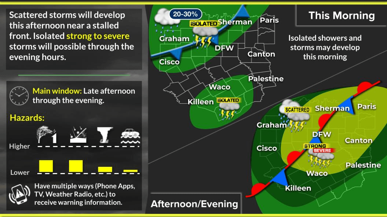
Good morning, let's proceed with the current weather situation. As of now, Gulf moisture is accumulating across North Texas in the form of a low cloud deck and exceptionally mild temperatures, with readings in the 60s. Today's temperatures are expected to rise to near 80 degrees, accompanied by intermittent sunshine. The combination of these factors, coupled with upper-level support and a dissipating cold front, will likely produce scattered strong and isolated severe storms between 4:00 p.m. and 10:00 p.m. today. Presently, the primary threats appear to be pocket change sized hail and wind gusts up to 60 mph, with a very low tornado threat. Approximately 50% of the area can expect to experience storms before the day concludes.
For Thursday and most of Friday, the majority of the region will remain dry before the next weather system arrives from the west. The Storm Prediction Center has placed our area under a level 2 out of 5 severe weather risk for late Friday afternoon into the evening hours. Hail larger than quarters, damaging winds, and a few tornadoes are possible late Friday, particularly during the early to mid-evening time frame. A higher tornado threat exists in eastern Oklahoma, where a level 3 out of 5 severe weather risk is in effect. Afternoon highs on both days will approach 80 degrees, contingent upon sunshine.
The next weather system will arrive before noon on Saturday. A stronger cold front will shift south of the area by afternoon, prompting shower and thunderstorm activity to form ahead of the front. Currently, it appears that the severe weather threat will be confined to areas south and east of the Dallas-Fort Worth area on Saturday. However, waves of heavy rain will move from southwest to northeast behind the front in a significantly cooler air mass. Temperatures will be near 70 degrees by 1:00 a.m. Saturday morning but will drop to the low 50s by late Saturday afternoon and into the upper 40s by Sunday morning. At least two inches of rain are expected during this time frame, although no severe weather is anticipated. Rain should taper off during the first half of Sunday, with highs struggling to reach 60 degrees. A warm front will pass through North Texas Sunday night, and by Monday, we will be back in the warm sector, with highs rising into the 70s. Gulf moisture will return, and we can expect another round of strong or severe storms sometime before mid-week.
Please be prepared for an active weather pattern over the next 7 to 10 days as we alleviate our rainfall deficit of over three inches. Thank you for following my page, and please enjoy the weather when you can, it's the only weather you've got!
7-Day Headlines:
* DFW Airport reached 84 yesterday.
* Weather aware later today. 4pm-10pm.
* Severe weather threat late Wednesday and Friday.
* Threats: Hail, wind, and isolated tornadoes.
* Flooding threat starts this weekend.
* 3.00"+ rain deficit will be erased.
* More storms and heavy rain next week.
*Yest Rain: 0.00"; Yest High: 84; Low: 65
*Today's Averages: High: 65; Low: 45
*Record high: 88 (1955, 2013); Record low 20 (2002)
*March rain: 0.00"; Deficit:
*2026 Rain: 2.24"; Snow: 2.4" Deficit:
*Sunrise: 6:51am; Sunset: 6:29pm
Wednesday: Morning clouds, some afternoon sun. Windy and mild. Scattered showers early, storms between 4pm and 10pm. Threats: Pocket change sized hail, wind, and isolated tornadoes. High: Upper 70s. Wind: South 15-25 mph.
Wednesday night: Scattered strong storms ending by midnight. Low: Low to mid 60s. Wind: South 10-15 mph.
Thursday: Morning clouds, some afternoon sun. Scattered showers and storms, mainly east of I-35E. High: Upper 70s. Wind: South 10-20, G30 mph.
Friday: Mostly to partly cloudy, breezy and warm. Scattered showers and storms, some severe by evening. Threats: Hail, wind, an isolated tornado. High: Upper 70s.
Weekend: Mostly cloudy and cooler. Waves of heavy rain. Some may be severe (south of DFW) on Saturday. Highs: 70s to 50s.
Monday: Mostly cloudy, breezy and warmer. Scattered showers and storms (NW of DFW). High: Low 70s.
Tuesday: Mostly cloudy, breezy and mild. Scattered showers and storms. Severe? High: Mid 70s.
LISTEN on the Audacy App
Tell your Smart Speaker to "PLAY 1080 KRLD"
Sign Up to receive our KRLD Insider Newsletter for more news
Follow us on Facebook | Twitter | Instagram | YouTube