


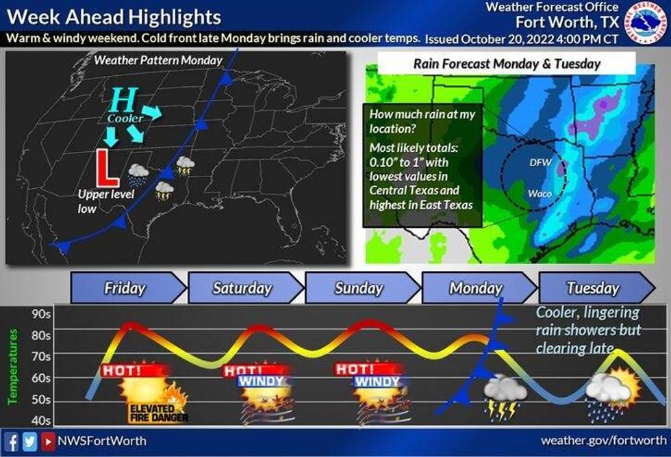
A grass fire danger, a lot of wind, a lot of warmth, a good chance for strong thunderstorms late Monday into early Tuesday, and then windy and cooler weather by the middle of next week. Those are your fabulous weather stories over the next 7 days.
This morning, skies are clear, humidity is rather low and temperatures are cool to start your Friday off. Plenty of sunshine, southerly winds gusting to 25 mph, and warming temperatures are expected today. Afternoon highs will top out in the upper 80s. Well above average for this time of the year.
 National Weather Service - Fort Worth
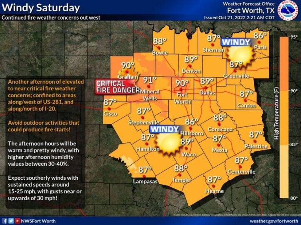
You'll wake up tomorrow morning to some low clouds, but they'll mix out by late morning giving way to a partly cloudy, warm and windy day. Afternoon highs will top out in the upper 80s again. The wind will gust to 35 mph from the south. There'll be a critical grass fire danger, especially west of 35W.
Sunday is a carbon copy of tomorrow's weather. Morning clouds, afternoon sun with highs in the mid to Upper 80s. A south will gust to 35 mph. If your travels take you up highway 287 towards Amarillo on Sunday, wind will gust to 55 mph in the Texas panhandle. The grass fire danger will be skyrocketing in these areas, also across the western half of Oklahoma. Please keep this in the back of your mind if you're heading that direction.
 National Weather Service - Fort Worth
Things start to change on Monday.. morning clouds and peaks of afternoon sun will be your weather story early. Afternoon highs will top out into the Low 80s. By Monday evening, a line of showers and storms will approach from the west. Some of these will become strong and there may even be one or two severe storms for wind and small hail. This line will press east of DFW before Tuesday morning, as a cold front comes into the area. There will be some wrap-around moisture in the form of clouds on Tuesday. It will be windy and much cooler with highs in the low to mid 60s. There may even be a few scattered showers around through early afternoon. Wind will gust from the WNW to 30 mph. Wind chills will be in the 50s.
Wednesday and Thursday look fantastic with chilly mornings and cool afternoons. Highs near 70 Wednesday, mid 70s by Thursday.
*Yest Rain: 0.00"; High: 85; Low: 502
*Today's Averages: High: 77; Low: 55
*Record high: 94 (1939, 1979); Record low: 36 (1898, 1917)
*October rain: 0.07"; October deficit: 2.58"
*2022 Rain: 23.49"; 2022 deficit: 6.43"
*Sunrise: 7:37am; Sunset: 6:48pm
Today: Sunny, windy and warm. High: Upper 80s. Wind: South 15-25 mph.
Tonight: Increasing clouds late. No rain. Not as cool. Low: 58-62. Wind: South 15-25, G30.
Saturday: Morning clouds, afternoon sun. VERY windy and warm. High: Upper 80s. Wind: South 15-25, G35 mph.
Sunday: Morning clouds, afternoon sun. Windy and warm. Grass fire danger west of DFW. Highs: 85-90.
Monday: Increasing clouds, breezy and warm. High: Low 80s. Chance of showers and strong storms by evening. High: Low 80s.
Tuesday: Chance for showers early, then mostly cloudy, windy and cooler. High: Low to mid 60s.
Wednesday: Sunny, windy and cool. High: Near 70.
Thursday: Sunny, less wind and a bit warmer. High: Mid 70s.

LISTEN on the Audacy App
Tell your Smart Speaker to "PLAY 1080 KRLD"
Sign Up and Follow NewsRadio 1080 KRLD


