


Good morning, and welcome to Friday. I hope everyone has had a productive work week. If you've been wishing for a warm and pleasant weekend, your wish has been granted.
We'll commence the day with temperatures ranging from the upper 40s to low 50s as you head out the door this morning. Abundant sunshine will dominate the day, with afternoon highs approaching 80 degrees, accompanied by southerly breezes.
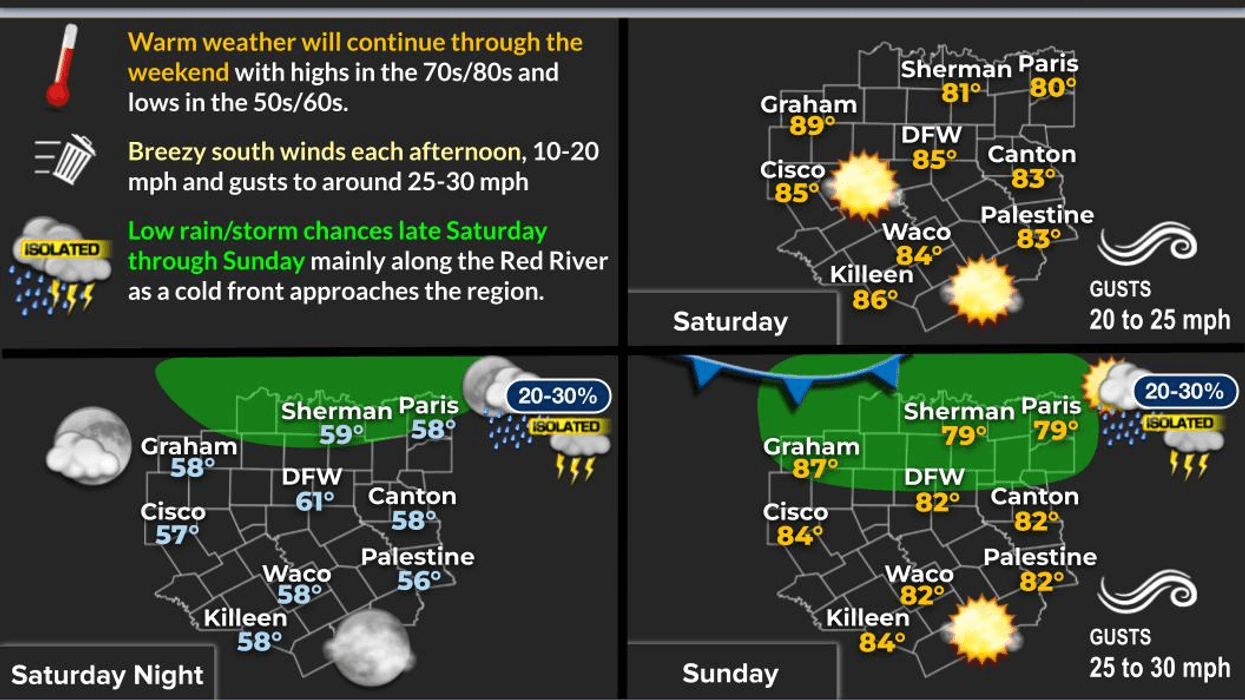
Southerly gusts will intensify, reaching 20 to 25 miles per hour throughout the weekend, with plenty of sunshine. Afternoon highs on both days will reach the low to mid-80s, approximately 20 degrees above average for this time of year.
Our first weather system will arrive late Sunday evening, as a cold front moves into the area. This front may bring scattered showers, although measurable rainfall is unlikely. The cooler air that follows will be short-lived, as the front will stall near the Dallas-Fort Worth area, making Monday's temperature forecast challenging. If you're behind the front, temperatures may remain in the 50s all day, while areas ahead of the front may reach 80 degrees once again.
By Tuesday, the front will rapidly move northward, and we'll be in the warm sector for the remainder of the week. The Gulf of Mexico will open up, bringing moisture and southerly breezes at 15 to 20 mph. Afternoon highs will be in the 70s, with morning clouds each day.
We're in need of rain, and the forecast for the timing, strength, and track of upper-level disturbances is complex. Most model data suggests the first chance for showers and isolated storms will be on Wednesday. These storms may develop in our area, but the severity appears low at this time. I'll continue to monitor the situation.
Another upper-level disturbance is expected to arrive towards the beginning of next weekend, appearing stronger, but it's beyond my 7-day forecast. I'll provide updates throughout next week.
Severe weather season is rapidly approaching, so please ensure you have multiple ways to receive warnings at your home or business.
That's all for now. Have a great Friday, and enjoy the weather when you can, it's the only weather you've got!
7-Day Headlines:
* DFW Airport reached 82 yesterday.
* A beautiful Friday ahead!
* A breezy and warm weekend to boot!
* Early Monday morning 'BRIEF' cold front. A few showers.
* Colder Monday, warming Tuesday and Wednesday.
* Increasing shower and thunderstorms chances starting late Tuesday.
* A wet Wednesday.
*Yest Rain: 0.00"; Yest High: 82; Low: 51
*Today's Averages: High: 64; Low: 43
*Record high: 85 (1918); Record low 19 (2006)
*February rain: 1.31"; Deficit:
*2026 Rain: 2.24"; Snow: 2.4" Deficit:
*Sunrise: 6:57am; Sunset: 6:25pm
Friday: Sunny and perfect. High: Near 80. Wind: NE 5 mph.
Friday night: Clear and cool. High: Low to mid 50s. South 5 mph.
Weekend: Mostly sunny, windy and warm. Highs: Low to mid 80s.
Sunday night: Stalling cold front after midnight. A few showers are possible. Low: 48 North; 62 South.
Monday: Cloudy with a few showers and areas of drizzle near a stalled cold front. High: 56 North; 80 South.
Tuesday: Mostly cloudy and warmer. Front lifts north. High: Near 80.
Wednesday: Cloudy and mild. Scattered showers and storms. High: Low 70s.
Thursday: Partly cloudy and pleasant. High: Upper 70s.
LISTEN on the Audacy App
Tell your Smart Speaker to "PLAY 1080 KRLD"
Sign Up to receive our KRLD Insider Newsletter for more news
Follow us on Facebook | Twitter | Instagram | YouTube


