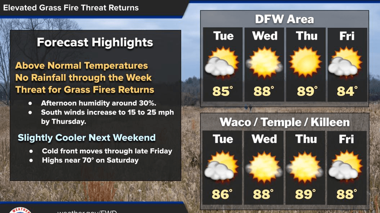
A warming trend is expected to persist through Friday noon, with an increased risk of grass fires tomorrow through Friday. A strong cold front is anticipated to arrive around noon on Friday, followed by a seven-day dry spell and significantly cooler temperatures late Friday into Saturday.
Good morning, and welcome to Tuesday. I hope you had a pleasant Monday. Current temperatures range from the mid-50s to low 60s across North Texas, accompanied by a cloud bank that will move southward by the morning hours, giving way to a mostly sunny sky. The return of a south wind will initiate a warming trend, with yesterday's high of 80 degrees expected to rise to 85 degrees today. South winds will intensify on Wednesday and Thursday, creating a high risk of grass fires, particularly west of Dallas and Fort Worth.
Following morning lows in the low 60s on Wednesday, afternoon highs will rebound into the upper 80s under plenty of sunshine, with south winds blowing at 10 to 20 mph.
Temperatures on Thursday will start in the mid-60s, ending the day with plenty of sunshine and afternoon highs near 92 degrees, potentially tying the record high for that date.
Morning lows will return to the mid-60s on Friday, with afternoon highs near 80 degrees by the noon hour. A cold front will pass through around lunchtime, dropping temperatures into the 50s by Friday evening, accompanied by extensive cloud cover and north winds gusting up to 30 mph, as the grass fire danger persists.
On Saturday morning, we can expect a cloudy sky with low temperatures around 46 degrees and wind chills in the upper 30s. Clouds will give way to a partly cloudy sky by mid-afternoon, with afternoon highs near 65 degrees.
Sunday morning will bring clear skies, with morning lows in the low 50s and afternoon highs warming quickly to near 80 degrees as south winds return.
Monday is expected to be equally pleasant, with warmer temperatures and highs near 85 degrees.
7-Day Headlines- * DFW Airport reached 80 yesterday.
- * A warming trend through Thursday.
- * Friday lunchtime cold front.
- * 80 degrees at noon, 50s by evening.
- * Clouds invade Friday into early Saturday afternoon. No rain as of now.
- * A cool Saturday, warming up Sunday and Monday.
*Yest Rain: 0.00”; Yest High: 80; Low: 58
*Today’s Averages: High: 71; Low: 50
*Record high: 89 (1929, 2018); Record low 39 (2006)
*March rain: 2.91”; Surplus: 0.44”
*2026 Rain: 5.15"; Snow: 2.4” Deficit: <1.36”>
*Sunrise: 7:25am; Sunset: 7:33pm
- Tuesday: Morning clouds, afternoon sun. South winds return. High: Mid 80s. Wind: South 5-15 mph.
- Tuesday night: Clear and mild. Low: Low to mid 60s. Wind: South 10-15 mph.
- Wednesday: Sunny, breezy, and warm. High: Upper 80s. Wind: South 10-20 mph.
- Thursday: Mostly sunny, wind and warm. Grass fire danger west of DFW. High: Low 90s.
- Friday: Increasing clouds, turning windy and MUCH colder by noon behind a DRY cold front. High: Near 80, falling into the 50s by early evening.
- Saturday: Morning clouds, some afternoon sun. Breezy and cool. Low: Mid to upper 40s. High: Mid 60s.
- Sunday: Partly cloudy, breezy and warmer. South winds return. High: Near 80.
- Monday: Partly cloudy and warmer. High: Mid 80s.
LISTEN on the Audacy App
Tell your Smart Speaker to "PLAY 1080 KRLD"
Sign Up to receive our KRLD Insider Newsletter for more news
Follow us on Facebook | Twitter | Instagram | YouTube
Cooler weather arrives by Friday
Cooler weather arrives by Friday