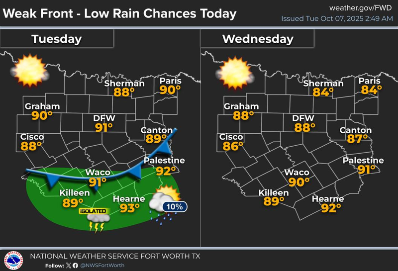
A weak cold front, a slight cool-down, a slight rain chance, and then absolutely nothing going on after that. A dominating area of high pressure will continue to control our weather over the next 7 to 10 days. Get accustomed to it.
Happy Tuesday, everyone. We have been stuck in a very quiet weather pattern with above average temperatures and below average precipitation over the past couple of weeks. With the exception of a weak cold front coming through the area today, this boring weather pattern will continue for the foreseeable future.
We are waking up to temperatures in the mid 60s to low 70s under a clear sky and a full Harvest Moon settling in the western horizon. I'm also tracking a cold front that just moved through Wichita Falls. It will arrive here shortly after lunch time and may produce a couple of showers as it moves through North Texas. A slightly better chance south of the Dallas-Fort Worth area will unfold later in the afternoon into the early evening hours, but most of you will stay dry. I still think we will manage to get up in the upper 80s today as the wind shifts to the Northeast at 5 to 10 miles per hour.
Slightly cooler temperatures will arrive overnight tonight, bottoming out in the upper 50s to mid 60s tomorrow. Plenty of sunshine will dominate the afternoon with highs in the mid 80s. This front will move back to the north on Thursday, but we will still enjoy the cool, comfortable morning, with upper 50s to mid 60s again under a clear sky. Afternoon highs on Thursday will warm back into the upper 80s.
Humidity levels will slowly increase Friday through the weekend and into early next week as southerly winds pick up a little bit. A strong ridge of high pressure in the upper levels of the atmosphere will dominate our weather through the weekend and through most of next week, with afternoon highs in the upper 80s, morning lows in the 60s.
We will eventually get a strong cold front through here. It is virtually impossible to tell you exactly when, but my gut feeling is that the last third of October will finally start to cool down, especially towards Halloween, like we always do.
Thanks for playing, have a great day today and enjoy the weather when you can, it is the only weather you have got.
7-Day Headlines:
DFW hit 92 degrees on Sunday.
Weak cold front today, rain chances are VERY low.
A tad cooler Wednesday and Thursday.
Upper level ridge returns Friday – Monday.
Above average temperatures return. No rain for the foreseeable future.
*Yest Rain: 0.00”; Yest High: 92 Low: 69
*Today’s Averages: High: 82; Low: 61
*Record high: 98 (1979, 2014); Record low: 42 (1952)
*October Rain: 0.00”; Deficit:
*2025 Rain: 28.16”; Surplus: 0.25”
*Sunrise: 7:27am; Sunset: 7:03pm
Tuesday: Mostly sunny and warm. Weak afternoon cold front. Slight rain chance, south of DFW. High: Near 90. Wind: NNE 5-10 mph.
Tuesday night: Clear and pleasant. Mild. Low: 58-66. Wind: NNE 10 mph.
Wednesday: Sunny and warm. Low humidity. High: Mid 80s. Wind: NNE 5-10.
Thursday: Mostly sunny and warm. High: Mid to upper 80s.
Friday – Sunday: Mostly sunny and warm. Highs: Near 90. Lows: 60s.
Monday: More of the same. Sunny and warm. High: Near 90.
LISTEN on the Audacy App
Tell your Smart Speaker to "PLAY 1080 KRLD"
Sign Up to receive our KRLD Insider Newsletter for more news
Follow us on Facebook | Twitter | Instagram | YouTube
