


I've been in this business for nearly 30 years, and my primary objective has always been to discuss various weather patterns every morning. Unfortunately, I'm growing increasingly dissatisfied with the current stagnant weather pattern. Rest assured, it will change eventually. :-)
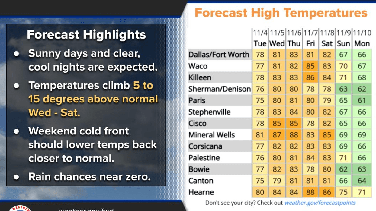
While it's been exceptionally pleasant in our area for the past few days, and this trend will continue through Saturday, a strong cold front will impact us late Saturday night, bringing chilly air for Sunday and Monday, followed by a rapid warm-up by mid-week. Regrettably, there is no precipitation forecasted for the next 7 to 10 days.
Happy Tuesday, ladies and gentlemen! I hope you have an excellent day today, and the weather will be equally impressive. This morning, we're starting off in the low to mid-50s, with temperatures reaching near 80 degrees this afternoon and breezy winds from the south at 10 to 20 mph. Tomorrow morning, temperatures will be in the mid to upper 50s, with mostly sunny, breezy, and mild conditions, and highs in the low 80s. This forecast will remain consistent for Thursday as well.
On Friday, a weak cold front will arrive, dropping temperatures slightly, but the wind shift will be barely noticeable. By Friday evening, the wind will shift back to the south, and Saturday will be sunny and beautiful, with afternoon highs reaching the low 80s.
Late Saturday night, a strong cold front will pass through, shifting winds to the north at 15 to 25 miles per hour, with higher gusts. Temperatures will drop to near 50 degrees by Sunday morning, with a north wind gusting up to 30 mph. Although sunshine will be abundant, temperatures will remain in the mid-50s throughout the day, with wind chills in the 40s, making it a chilly and raw day.
On Monday morning, a relaxing wind, and a clear sky will allow temperatures to plummet. The 32 degree line will approach Highway 380, and a widespread frost will occur. I'll remind you on Sunday to protect your plants and pets before bedtime. Monday will be sunny and cool, with highs struggling to reach 60 degrees, followed by a rapid warm-up.
I recommend watering your yard and gardens over the next week, as they will appreciate it. Have a great day today and enjoy the weather while you can, it's the only weather you've got.
7-Day Headlines:
DFW hit 78 degrees on Monday.
Above average temperatures through Saturday.
Morning clouds Wednesday and Thursday.
Windy weather returns.
Grass fire danger.
No rain for a while.
A strong cold front arrives late Saturday.
*Yest Rain: 0.00"; Yest High: 78 Low: 49
*Today's Averages: High: 71; Low: 50
*Record high: 90 (2017); Record low: 25 (1991)
*November Rain: 0.03"; Deficit:
*2025 Rain: 32.94"; Surplus: 0.96"
*Sunrise: 6:50am; Sunset: 5:33pm
Tuesday: Sunny and beautiful again! Breezy. High: Upper 70s. Wind: South 15-25 mph.
Tuesday night: Clear and comfortable. Low: Mid to upper 50s. Wind: South 10-20 mph.
Wednesday: Morning clouds, afternoon sunshine. Warm and breezy. High: Low 80s.
Thursday: Morning clouds, afternoon sunshine. Warm and windy. High: Mid 80s.
Friday: Partly cloudy, continued nice. High: Low 80s.
Saturday: Mostly sunny, breezy and warm. Strong cold front late. High: Low 80s.
Sunday: Morning cloud, then rapid clear. VERY windy and MUC cooler. High: Mid to upper 50s.
Monday: Morning frost (widespread) and freezes (north of DFW). Sunny, continued nice. Lighter wind. High: Upper 50s.
LISTEN on the Audacy App
Tell your Smart Speaker to "PLAY 1080 KRLD"
Sign Up to receive our KRLD Insider Newsletter for more news
Follow us on Facebook | Twitter | Instagram | YouTube


