Above-average precipitation and below-average temperatures are anticipated across North Texas over the next week. A severe weather risk is in the forecast for Friday and again by the middle of next week.
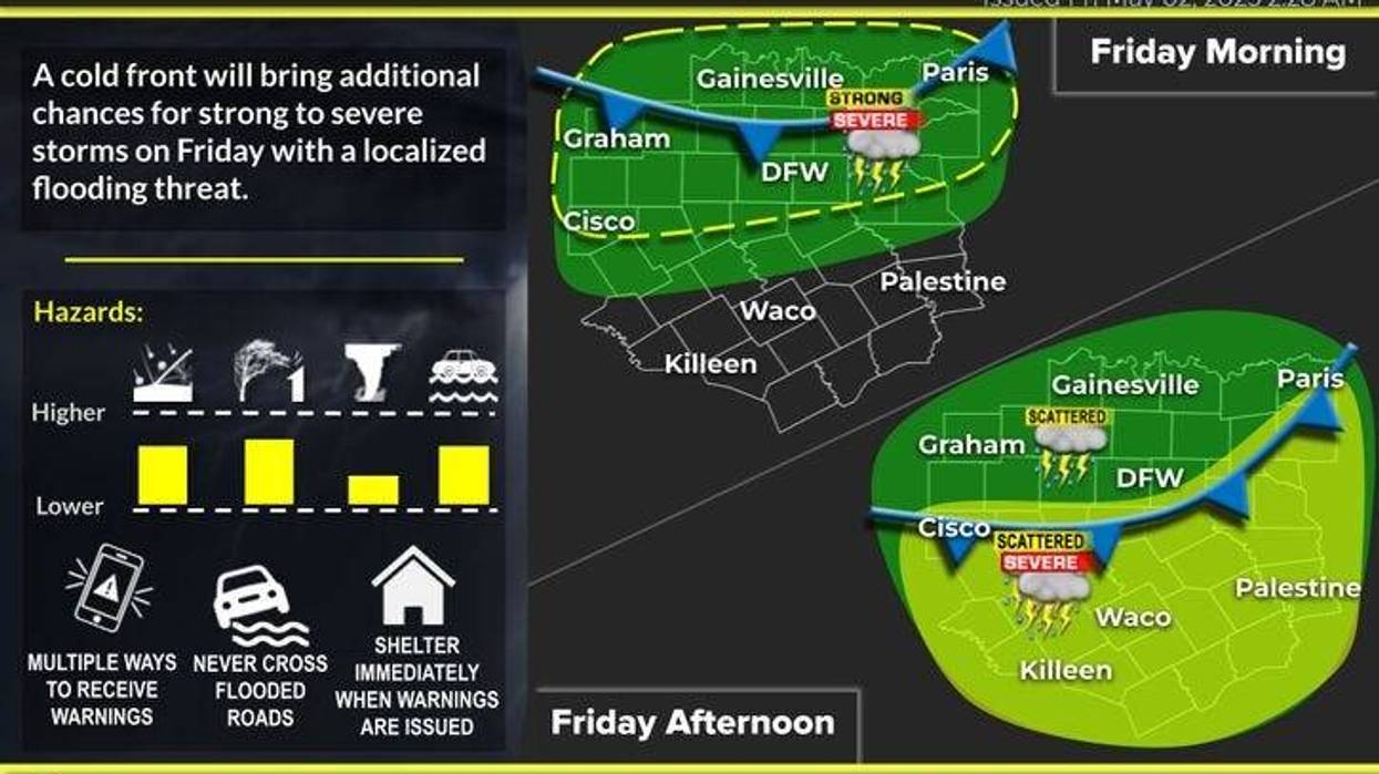
Following a rainy mid-week, shower and thunderstorm chances will increase throughout the day on Friday. A complex of storms is expected to impact the Red River counties in the morning, with scattered showers possible west of Fort Worth. Temperatures will range from the low to mid-60s.
Shower and thunderstorm redevelopment is anticipated after noon across the Dallas-Fort Worth area, potentially producing hail and wind. The severe threat is expected to be south of the Dallas-Fort Worth area by mid-to-late afternoon. All modes of severe weather are possible south of Interstate 20, including isolated tornadoes. Temperatures will struggle to reach 80 degrees. The system will move south by this evening, with lingering clouds through Saturday morning.
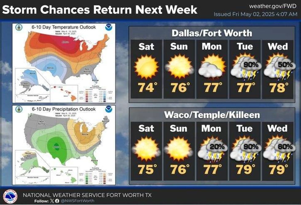
Cooler temperatures are expected for Saturday morning, with highs in the mid-70s and lows in the 50s anticipated for the weekend. A quiet start to next week is forecast, with scattered showers and storms returning by late Tuesday. Some of these storms may become severe.
 North Texas 5-day forecastNational Weather Service
7-Day Headlines
DFW hit 73 degrees on Thursday.
Afternoon and early evening storms. Some severe.
Threats: Large hail, damaging wind, isolated tornadoes (south).
A nice and comfortable weekend!
A decent Monday.
More storms are expected late Tuesday through Thursday. Some severe.
*Thursday Rain: 0.00"; Thursday High: 79 Low: 60
*Friday's Averages: High: 79; Low: 60
*Record high: 95 (1943): Record low: 44 (1970, 2013)
*May Rain: 0.00"; Deficit:
*2025 Rain: 13.93"; Surplus: 1.97"
*Sunrise: 6:39am; Sunset: 8:12pm
Friday: Morning severe storms along Red River counties. High: Near 80. Wind: NE 5-10 mph.
Friday night: Leftover evening showers, south of I-30, then mostly cloudy. Low: 48-55. NE 10-15 mph.
Saturday: Morning clouds, afternoon sun. Beautiful! High: Mid 70s. North 10-20 mph.
Sunday: Partly cloudy and pleasant. High: Mid to upper 70s.
Monday: Partly cloudy, continued nice. High: Near 80.
Tuesday: Mostly cloudy. Scattered showers and strong storms late. Highs: Low 80s.
Wednesday and Thursday: Scattered showers and storms. Highs: Near 80.
LISTEN on the Audacy App
Tell your Smart Speaker to "PLAY 1080 KRLD"
Sign Up to receive our KRLD Insider Newsletter for more news
Follow us on Facebook | Twitter | Instagram | YouTube