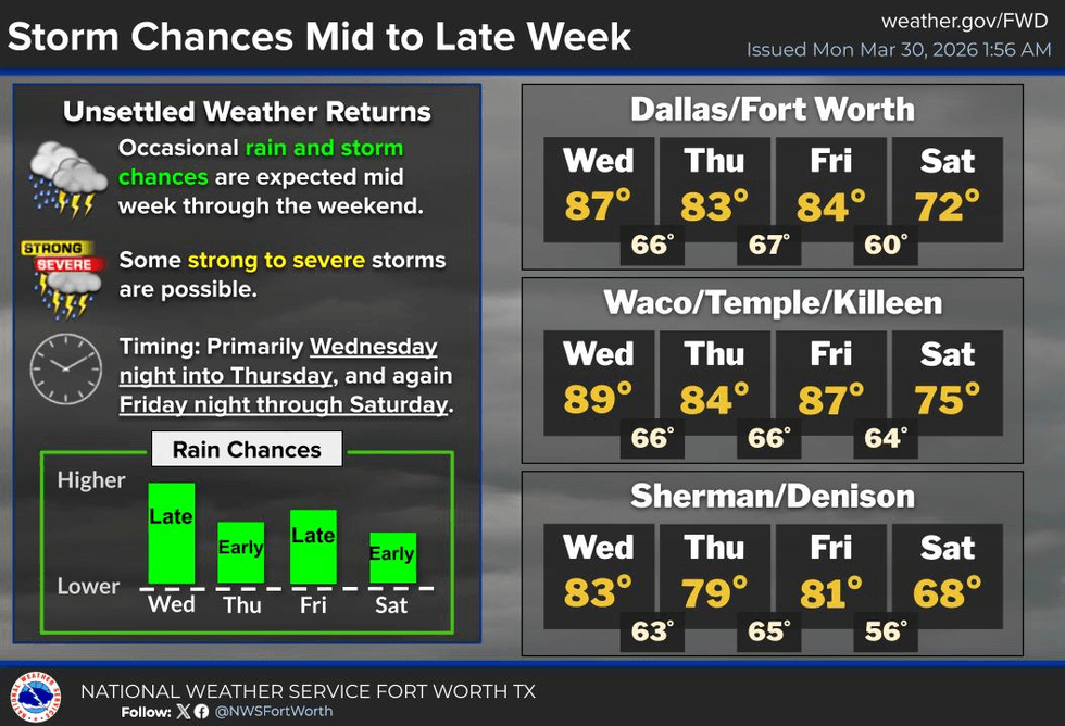
After a picturesque weekend, a significant weather change is anticipated by the middle and end of this week. April is expected to bring areas of heavy rain and isolated severe storms on Wednesday night and again from Friday night into Saturday.
Good morning, everyone. I hope your weekend was exceptional. We are waking up to temperatures in the low to mid-60s with low clouds invading from the south throughout the morning. These clouds will dissipate by late morning, giving way to a partly cloudy, warm, and windy afternoon. Afternoon highs will jump into the low to mid-80s, with south winds gusting up to 25 mph. This forecast will repeat on Tuesday and Wednesday.
By Wednesday night, an area of showers and storms will form to the west along the dry line. Currently, areas from Wichita Falls southwest to Abilene to San Angelo are expected to experience storm formation by late afternoon into early evening. These clusters of storms will form into a line and move through the area late Wednesday night into early Thursday morning. High winds, hail, and isolated tornadoes are possible as this line moves through the area while you're sleeping. Rain will end before your morning commute on Thursday.
Thursday and most of Friday will be relatively quiet, with afternoon highs returning to the 80s. Gusty southerly winds will continue to bring moisture back in from the Gulf. By Friday night, the dry line will surge east, with a cold front heading in from the northwest, arriving sometime during the first half of Saturday. Showers and storms will form along the dry line as well as the cold front. We might experience a 1-2 punch, or the cold front may catch up to the dryline. There is still time to analyze the data and fine-tune this forecast.
Currently, the threats appear to be hail, wind, and isolated tornadoes. Additionally, there is a heavy rain and flooding threat across parts of North and especially Central and East Texas on Saturday. The outcome depends on the speed, track, and strength of the system. I have several days to analyze the data and will fine-tune this forecast as we approach the end of the week and Easter weekend.
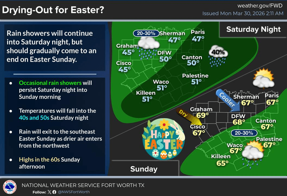
As of now, Easter Sunday looks fantastic, with partly sunny, windy, and much drier air, and pleasant temperatures in place. However, Easter egg hunts on Sunday morning might be a bit chilly and breezy for the children. I will keep you updated.
Have a terrific day today and enjoy the weather while you can.
7-Day Headlines:
- DFW Airport reached 83 on Sunday.
- Morning clouds, afternoon sun through Wednesday.
- A bunch of wind this week.
- Scattered severe storms late Wednesday..
- Scattered severe storms late Friday into Saturday.
- Watching flooding through Saturday.
- A cool and breezy Easter.
Almanac:
- Yest Rain: 000”; Yest High: 83; Low: 48
- Today’s Averages: High: 73; Low: 51
- Record high: 95 (1946); Record low 29 (1987)
- March rain: 2.91”; Deficit: <0.17”>
- 2026 Rain: 5.16”; Snow: 2.4” Deficit: <3.22”>
- Sunrise: 7:17am; Sunset: 7:48pm
7-day Forecast:
- Monday: Morning clouds, afternoon sun. Windy and warm. High: Mid 80s. South 15-25, G30 mph.
- Monday night: Increasing clouds, breezy and mild. Low: Mid 60s. Wind: South 15-25 mph.
- Tuesday: Morning clouds, afternoon sun. Windy and warm. High: Mid 80s. South 15-25, G30 mph.
- Wednesday: Morning clouds, afternoon sun. Windy and warm. Showers and storms arrive by late evening. A few may become severe. Threats: Hail, gusty wind, an isolated tornado. High: Mid 80s.
- Thursday: Morning showers, then mostly to partly cloudy and mild. High: Mid 80s.
- Friday: Morning clouds, afternoon sun. Windy and warm. Morning clouds, afternoon sun. Windy and warm. Showers and storms arrive by late evening. A few may become severe. Threats: Hail, gusty wind, an isolated tornado. High: Mid 80s.
- Saturday: Showers and storms a good bet. Heavy rain and severe threat drifts south. High: Low 70s.
- Easter Sunday: Sunny, windy and cool. Low: Near 50; High: Near 70.