


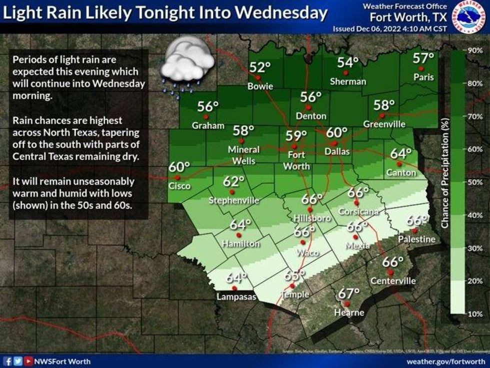
We're waking up to temperatures near 60° this morning with a few clouds out. Nothing showing up on radar at the present time, but that will change by this evening.
We've got a cold front that'll be sagging south of the Red River overnight, and an upper level disturbance riding along this front during the day tomorrow. This will make for a pretty wild day on Tuesday with the big temperature spread from Highway 380 North to Highway 380 South. This area will be the dividing line between temperatures in the 50s tomorrow to our north and readings in the low 70s to our south. We'll be right in between so it's a close call for our afternoon high. Regardless, there will be some rain cruising across the area throughout the day, we may measure a quarter of an inch before the end of the day tomorrow. The one inch rainfall totals will be confined to Oklahoma.
 National Weather service - Fort Worth
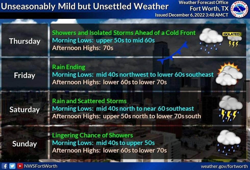
There will be one last chance for some rain on Thursday as a cold front comes into the area. Average rainfall totals will be less than a quarter of an inch again. It will be cooler on Friday as we clear out. Afternoon highs and the low 60s with much drier air filtering in.
As of now, the weekend looks a little bit wet. More rain is in the forecast for Saturday with highs and the low 60s. There could be a few leftover showers on Sunday and Monday with temperatures approaching 70 degrees again by early next week. As of now, the heaviest rainfall totals look to be on Saturday...there may even be some thunder around.
 National Weather service - Fort Worth
Lastly, some of the extended data I'm analyzing has a pretty strong cold front coming through here by Tuesday of next week, dropping temperatures to below seasonal averages.
*Yest Rain: 0.00"; High: 81R; Low: 57
*Today's Averages: High: 60; Low: 40
*Record high: 84 (1966); Record low: 11 (1950)
*December rain: Trace; Deficit: 0.42"
*2022 Rain: 34.25"; 2022 deficit: 0.34"
*Sunrise: 7:17am; Sunset: 5:21pm
Today: Increasing clouds, mild and muggy. A few showers late in the day. High: Low to mid 70s. Wind: SSW 5-10 mph.
Tonight: Cloudy, mild and muggy. Scattered showers. Low: 50-63. Coolest temps north of Hwy 380. Wind: South/North 5-10 mph.
Tomorrow: Cloudy with scattered showers. High: 55-73. Coolest north of Hwy 380. Wind: Variable 5-10 mph.
Thursday: Mostly cloudy, mild and muggy. A few leftover showers, especially north of DFW. High: Low to mid 70s.
Friday: Mostly sunny and a bit cooler. Lower humidity. High: Low 60s.
Saturday: Mostly cloudy. Chance of showers and storms. High: Low to mid 60s.
Sunday: Partly cloudy and mild. High: Near 70.
Monday: Partly cloudy and mild. Chance of showers. High: Low 70s.

LISTEN on the Audacy App
Tell your Smart Speaker to "PLAY 1080 KRLD"
Sign Up and Follow NewsRadio 1080 KRLD


