There were several reports of wind damage Monday night and early Tuesday morning and the National Weather Service will be surveying damage reports in areas north and south of Dallas-Fort Worth.
Rainfall totals ranged from half an inch to 4 inches across North Texas. DFW Airport received a little over an inch.
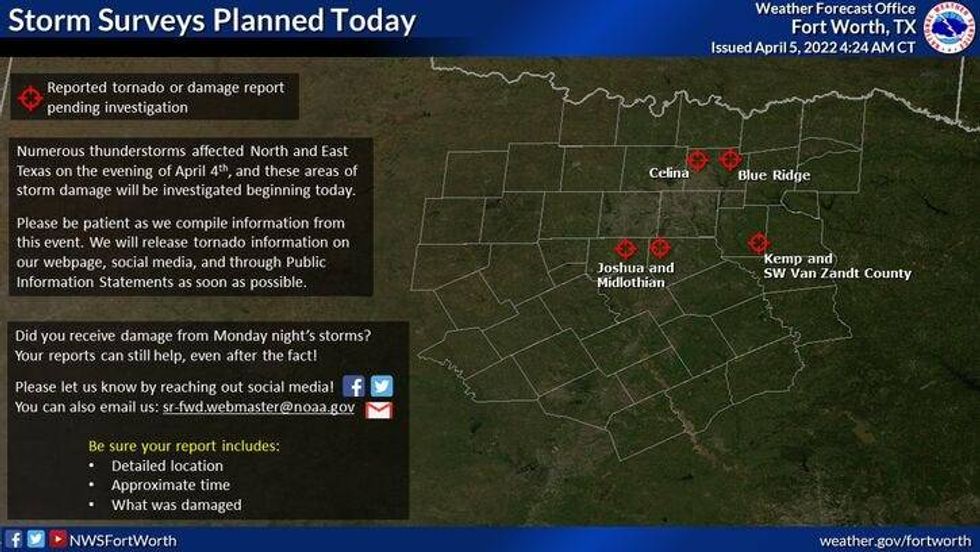 The National Weather Service will survey damage at five sites across North Texas on Tuesday, April 5, 2022.National Weather Service
Skies partially cleared Tuesday morning and some patchy fog developed in some areas, especially northwest of DFW. That will burn off by mid-morning.
Plenty of sunshine and very warm temperatures is the weather story Tuesday. Highs will reach the mid to upper 80s!
Dry cold front number one arrives before daybreak Wednesday morning. We'll start the day off in the low to mid-50s. Wind gusts to 30 mph, plenty of sunshine and highs in the mid to upper 60s will greet you.
You may want to protect your plants Thursday and Friday morning as temperatures may fall into the mid to upper 30s north and west of DFW and 40s in the immediate metroplex. High temperatures Thursday and Friday will be in the mid to upper 60s with plenty of sunshine and a lot of wind.
The weekend is looking nice as we warm back into the 80s with plenty of sunshine. A slight rain chance returns next Monday, but it doesn't look very promising right now.
That's all I've got. It was a long night last night so I will end it by saying.... have a wonderful day!
__________________________________________________

7-Day Headlines:
* High Monday: 81 degrees at DFW. 1.31" at DFW
* 0.50" to 4.00" of rain fell across North Texas.
* Storms are over.
* Very warm Monday.
* Two DRY cold fronts, Wednesday and Thursday.
* A cooler and windy end to the week.
* Warming into the weekend.
_______________________________________________________
*Monday Rain: 1.31"; *Monday High: 81; Low: 59
*Tuesday's Averages: High: 74; Low: 53
*Record high: 89 (1930, 1935); Record low: 32 (1920)
_______________________________________________________
*April rain: 1.33"; April surplus: + 1.03"
*2022 Rain: 5.38"; 2022 deficit
*Sunrise: 7:11 a.m.; Sunset: 7:51 p.m.
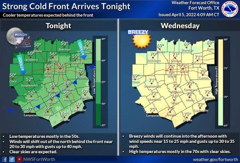 A cold front is expected to arrive in North Texas by Wednesday morning.National Weather Service
Tuesday: Mostly sunny and very warm. High: Mid to upper 80s. Wind: SSW 10-20 mph
Tuesday night: Increasing clouds and cool. Low: Low to mid 50s. Wind: SSW 10-20 mph.
Wednesday: Mostly sunny, windy and cooler. High: Mid to upper 60s. Wind: North 15-25, G30 mph.
Thursday. Protect plants in the morning. Sunny and very windy and cool. High: Mid 60s.
Friday: Protect plants in the morning. Sunny, less wind and continued cool. High: Upper 60s.
Saturday: Sunny and perfect. High: Near 80.
Sunday: Mostly sunny. Our warm up continues. High: Low 80s.
Monday: Partly cloudy and warm. Slight chance of showers and storms. High: Low 80s.

LISTEN on the Audacy App
Sign Up and Follow NewsRadio 1080 KRLD