


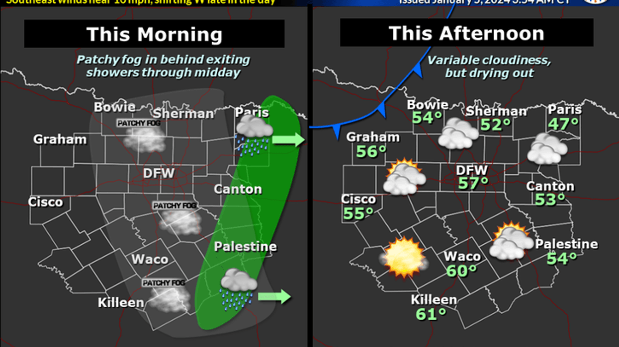
We're starting Friday with a mostly cloudy sky with temperatures in the 40s. Skies will clear through the day as a cold front comes into the area later on this afternoon. Afternoon highs will warm into the upper 50s. Southeast winds will shift to the north and gust to 25 mph this evening.
Our weekend looks nice. Plenty of sunshine on Saturday. Morning lows will dip into the upper 30s to low 40s, afternoon highs will reach the mid-fifties. Sunday looks equally as nice with plenty of sunshine. Afternoon highs will reach near 60°.
 National Weather Service - Fort Worth
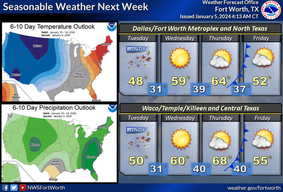
Our next weather maker and it will be a doozy, will arrive on Monday. Widespread shower activity will break out. Even some strong thunderstorms south of a Waco to Lufkin line. Afternoon highs will reach the low 60s with a south wind gusting to 30 mph.
The wind will shift to the north late Monday night bringing a brief cool down into Tuesday. There may be some wrap-around moisture early Tuesday morning in the form of some light rain or some rain-snow mix. It all depends on the track of the upper level low. If anything does fall temperatures will be safely above freezing and no accumulations are expected. The chance of this happening is low.
 National Weather Service - Fort Worth
We'll wake up Tuesday morning to temperatures in the mid 30s. Wind chills will be in the twenties with a north wind gusting to 35 mph. Afternoon highs will struggle to reach 50°.
A rapid warm up is on the way for Wednesday and Thursday with highs back into the 60s.
I do want to add that there's a lot of buzz about Arctic air spilling into the area the following weekend into the following week. Model data is struggling to bring this cold air into Texas. Please remember I don't forecast past 7 days, but it is something to keep an eye on.
*Yest Rain: 0.45"; Yest High: 58; Low: 36
*Today's Averages: High: 56; Low: 36
*Record high: 82 (1927); Record low: 9 (1942, 1947)
*January rain: 0.84"; Surplus: 0.47"
*2024 Rain: 0.84"; Surplus: 0.47"
*Sunrise: 7:31am; Sunset: 5:36pm
Today: Morning clouds, afternoon sun. Weak front arrives later today. High: Mid to upper 50s. Wind: SE 10-20 mph.
Tonight: Clear, breezy and chilly. Low: 38-42. Wind: NW 15-25 mph.
Tomorrow: Sunny and cool. High: Low to mid 50s. Wind: NW 10-20 mph.
Sunday: Mostly sunny, windy and a bit milder. Increasing clouds by evening. High: Near 60.
Monday: Cloudy, windy and mild. Rain chances return. Some strong storms south of DFW. High: Low 60s.
Tuesday: Morning showers, rain/snow mix north of DFW...then decreasing clouds, windy and colder. High: Mid to upper 40s.
Wednesday: Sunny and warmer. High: Low 60s.
Thursday: Sunny, windy and NICE! High: Mid to upper 60s.
LISTEN on the Audacy App
Tell your Smart Speaker to "PLAY 1080 KRLD"
Sign Up to receive our KRLD Insider Newsletter for more news
Follow us on Facebook | Twitter | Instagram | YouTube


