Coldest air of the fall season has arrived across North Texas. Freeze warnings continue through mid-morning. Don't forget to layer up if you're going to be working outdoors before noon.
Happy Monday ladies and gentlemen. I hope you had a terrific weekend and were able to complete yard work. We're waking up to very chilly temperatures for this time of year, ranging from 28 to 36 degrees, with the warmest temperatures recorded at DFW Airport. Freeze warnings remain in effect through mid-morning.
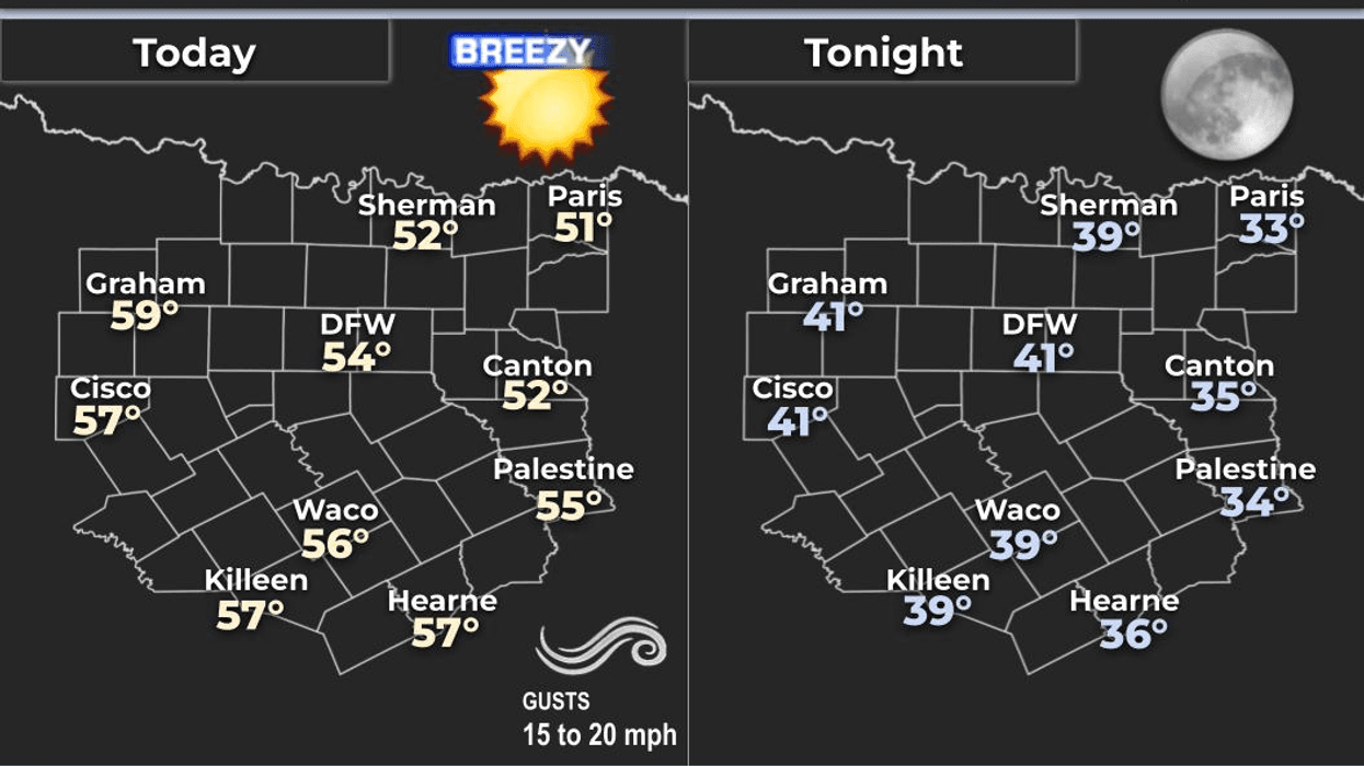
Today will be sunny and cool with less wind. Afternoon highs will top out in the mid to upper 50s, approximately 10 degrees below average for this time of year. The wind will slowly return from the south overnight, keeping temperatures slightly elevated.
Morning lows will range from 35 to 43 degrees under clear skies.
The rest of the week will be quite windy with a warming trend. Afternoon highs for Veterans Day Tuesday will reach the upper 60s with plenty of sunshine. Temperatures will continue to warm throughout the week. We can expect sunshine and 76 degrees on Wednesday, with low 80s returning on Thursday and Friday. The south wind will increase to 30 mph, creating a critical grass fire danger across much of the state. Please be aware of this.
Our next weather maker is still developing in the open Pacific. Model data will not be accurate regarding track, speed, and precipitation totals for North Texas this weekend.
This will change as we move into Thursday and Friday. By then, I will have a better understanding of how much rain we can expect across North Texas this weekend and whether any storms will be severe. I suspect that with temperatures well into the 80s on Thursday and Friday, and plenty of Gulf moisture in place, most of us will see some welcome rain. I will continue to monitor the severity of the storms.
In the meantime, enjoy the beautiful weather when you can, it's the only weather you've got!
7-Day Headlines:
DFW hit 61 degrees on Sunday.
Freeze Warning until 9am for all of North Texas.
Another cool day today.
Warming up fast through the week.
A VERY windy week.
Weather changes this weekend.
Showers and storms return.
Some storms may become severe.
*Yest Rain: 0.00"; Yest High: 69 Low: 48
*Today's Averages: High: 69; Low: 48
*Record high: 86 (1934, 1949); Record low: 26 (1950)
*November Rain: 0.03"; Deficit:
*2025 Rain: 32.94"; Surplus: 0.36"
*Sunrise: 6:55am; Sunset: 5:29pm
Monday: Sunny and cool. Less wind. High: Mid to upper 50s. Wind: North 5-10 mph.
Monday night: Clear, breezy and cool. A south wind returns. Low: 38-42. Wind: South 10-20 mph.
Veteran's Day: Clear, windy and cool. Grass fire danger. High: Near 70.
Wednesday: Clear, breezy and warmer. High: Mid to upper 70s.
Thursday and Friday: Mostly sunny, breezy and warm. High: Low 80s.
Saturday: Mostly cloudy, breezy and mild.
Scattered showers and strong storms return. High: Mid to upper 70s.
Sunday: Mostly cloudy and mild. Scattered showers and storms continue. High: Upper 60s.
LISTEN on the Audacy App
Tell your Smart Speaker to "PLAY 1080 KRLD"
Sign Up to receive our KRLD Insider Newsletter for more news
Follow us on Facebook | Twitter | Instagram | YouTube