


We're waking up to temperatures mainly in the 50s this morning with some patchy dense fog in areas. This fog will burn off after 9 AM giving way to a partly cloudy and warm day today. Afternoon highs will approach 80゚ in DFW, but much cooler towards the Red River Valley with highs only in the 60s up there.
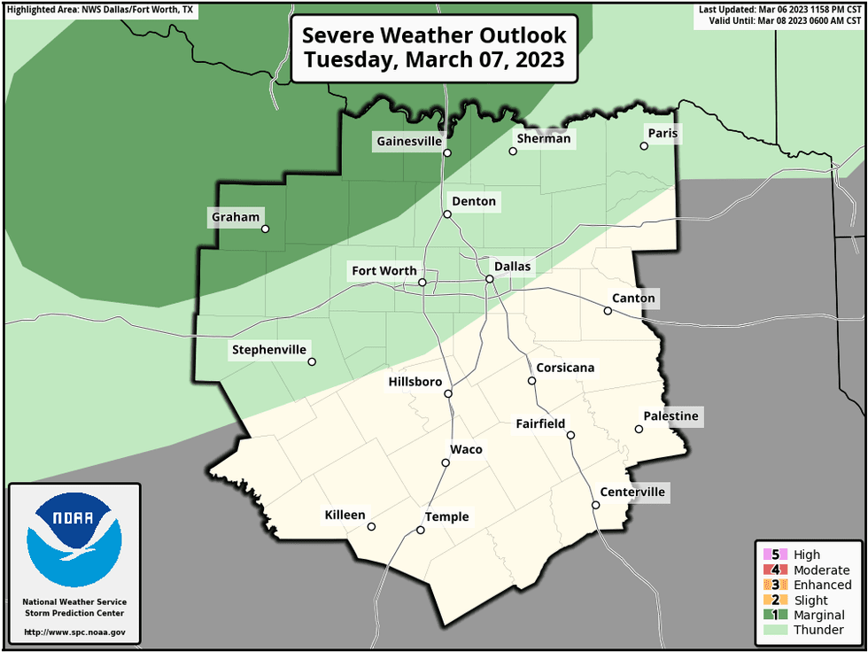
This front will slowly sag towards I 20 by this evening. There is also a threat for a few isolated strong to severe storms just NW of the DFW area. Hail and wind are the threats.
 National Weather Service - Fort Worth
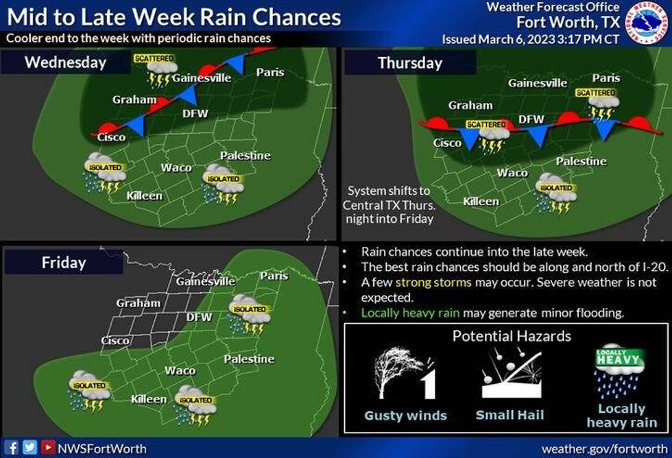
Temperatures overnight tonight will range between 45 and 65 with a few scattered showers around. This front will be draped along I-20 tomorrow through most of the day. This will be the focal point for scattered showers and storms.
The greatest chance for widespread rain will be along and north of highway 380. An isolated severe storm is also possible, but doubtful. Afternoon highs will range from 55 to 65 . The warmest temperatures will be south of the front.
 National Weather Service - Fort Worth
We'll get a bit of a break in the rain the first 2/3rds of Thursday, as the front briefly lifts back to the north. Thursday's highs will range between 55゚ to 75゚. By Thursday evening, the front comes back through the area. A line of showers and strong storms will develop along this boundary. Hail and wind will be the threats. A couple could be severe, especially south of DFW.
Friday looks nice with decreasing clouds and high temperatures in the mid sixties.
Saturday we warm up, highs will be back in the mid to upper 70s, but we lose an hour of sleep into Sunday morning, as another cold front comes through the area by noon. Highs will reach the low 70s early and then fall into the 60s late in the day.
Monday looks nice Sunny windy and cooler with high near 60゚.
*Yest Rain: 0.00"; Yest High: 82; Low: 58
*Today's Averages: High: 66; Low: 46
*Record high: 90 (1911); Record low: 20 (1920,43,89)
*March Rain: 0.82"; Surplus: 0.15"
*2023 Rain: 6.17"; Surplus: 0.21"
*Sunrise: 6:49am; Sunset: 6:30pm
Today: Patchy morning fog, afternoon sun. Warm again. Isolated late afternoon and evening strong storms just west and NW of DFW. High: Near 80. Wind: NE 5 mph.
Tonight: Increasing clouds, Scattered showers and isolated storms. Best chances north of I-20. Low: 45 North; 65 South. Wind: NW 5-10 mph.
Tomorrow: Cloudy and cool north of I-20, warmer south. Scattered showers and storms, especially north of I-20. High: 55 North; 65 South. Wind: NW 5-10 mph.
Thursday: Cloudy and muggy. Scattered showers and some strong storms by evening. High: 55 North; 75 South.
Friday: Morning showers, then decreasing clouds and a bit cooler. High: Mid 60s.
Saturday: Mostly sunny and warmer. High: Mid to upper 70s.
Sunday: Mostly sunny, turning cooler after the noon hour. High: Near 70 early, falling through the 60s in the afternoon.
Monday: Sunny and cool. High: Near 60.

LISTEN on the Audacy App
Tell your Smart Speaker to "PLAY 1080 KRLD"
Sign Up to receive our KRLD Insider Newsletter for more news


