


Will the unsettled January weather pattern persist as we approach the end of the month? At least for the next two and a half days, the weather will be exceptional, characterized by cool afternoons and chilly mornings.
Temperatures dropped to the low to mid-20s Friday morning, accompanied by a light wind under a clear sky. Friday will be sunny and cool, with afternoon highs approaching 50 degrees. Thursday's high was 51 degrees, which is below the average high of 57 degrees.
Another freeze is expected for Friday morning, with temperatures reaching the mid-to-upper 20s. Saturday will be sunny, with highs in the mid-50s.
For the most part, Saturday will be uneventful, with temperatures warming up to the mid-50s. Cloud cover will increase throughout the day. A large area of rain will develop to the south and southwest late on Saturday and move across the area through the early morning hours. A trailing cold front will pass through, pushing the rain to the south and east of Dallas-Fort Worth on Sunday.
Sunday will be cloudy and colder, with highs only in the mid-to-upper 40s. There will be some light rain in the area, but it appears that the more significant rain will remain south and east of us. The unsettled weather pattern will persist from next Monday to Wednesday, as an area of low pressure in the upper levels of the atmosphere stalls over the desert southwest. Energy spokes will rotate around the system, creating a lift over the cooler air mass that is in place. High temperatures will hover in the low to mid-50s each day, with waves of showers moving across the area.
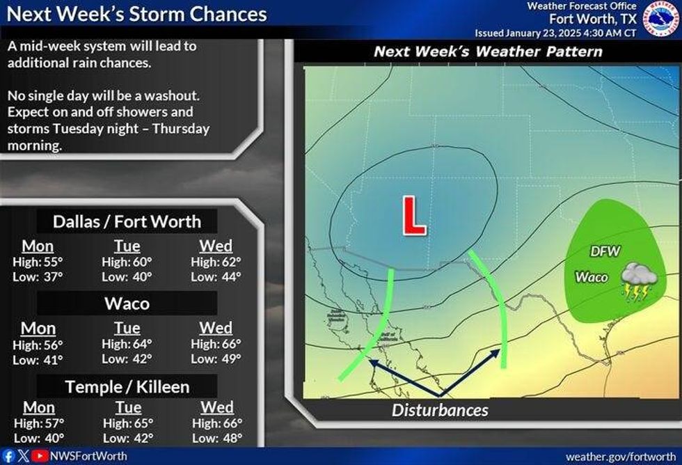 North Texas weather early next week.National Weather Service
7-Day Headlines
* DFW Airport reached 51 on Wednesday.
* Pipe-bursting cold Thursday morning.
* High temperatures in the 50s through Saturday, cold starts.
* Rain chances return Starting late Saturday.
* Sunday morning cold front.
* Chilly with on-and-off rain chances next week.
_____________________________________________________
*Wednesday Rain: 0.00"; Wednesday High: 51; Low: 22
*Thursday's Averages: High: 57; Low: 36
*Record high: 88 (1943); Record low: 9 (1966)
________________________________________________________
*January Rain: 1.56"; Deficit:
*2025 Rain: 1.56; Snow: 2.30"; Deficit:
*Sunrise: 7:28am; Sunset: 5:52pm
________________________________________________________
Thursday: Mostly sunny, and cool. High: Near 50. Wind: North 5-10 mph.
Thursday night: Clear and cold. Low: Mid to upper 20s. Protect pipes, pets, people and plants. Wind: Lt. Var.
Friday: Mostly sunny and seasonable. High: Mid-50s. Wind: SW 5-10 mph.
Saturday: Increasing clouds. Chance of showers late. High: Mid-50s.
Sunday: Morning cold front, chance of showers. Colder. High: Mid to upper 40s.
Monday and Tuesday: Mostly cloudy and cool. Chance of showers. High: Low to mid-50s.
Wednesday: Cloudy and cool. The chance of showers continues. High: Mid-50s.
LISTEN on the Audacy App
Tell your Smart Speaker to "PLAY 1080 KRLD"
Sign Up to receive our KRLD Insider Newsletter for more news
Follow us on Facebook | Twitter | Instagram | YouTube


