


Below-average temperatures and above-average precipitation, those are our weather stories over the next 7 days!
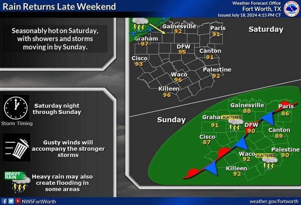
It's a quiet morning across North Texas as temperatures have fallen into the 70s with a few clouds overhead. Nothing is showing up on radar and I don't expect any rain today and most of tomorrow. Afternoon highs today will reach the low 90s today Friday, mid-90s on Saturday.
Our pattern change starts to unfold on Sunday as winds turn northwesterly in the upper levels of the atmosphere. This is a very unsettled weather pattern which allows disturbances to roll in from the northwest . As these disturbances interact with daytime heating and another cold front into the area early next week, widespread shower and thunderstorm activity will break out. The first strong disturbance arrives on Sunday, the second disturbance arrives on Monday dragging the cold front with it. These are the rainiest two days expected in my 7-day forecast. With the clouds and rain around, temperatures will hover in the 80s through the period. 70s in the rain. It's still way too early to tell you where the heaviest rain bands will set up, but if you have outdoor plans over the next 4 days, you need to get things taken care of today and tomorrow.
 NWS
NWS
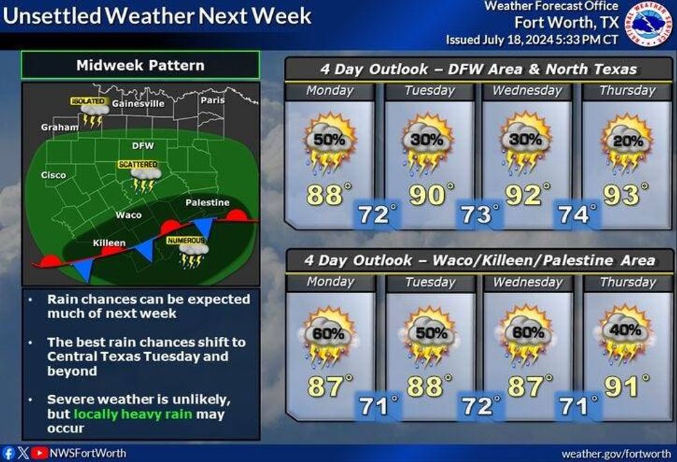
As of now, I'm thinking the heaviest rain shield will press south of Interstate 20 on Wednesday and Thursday, but with a northwesterly flow continuing in the upper levels of the atmosphere, I can't rule out some scattered showers and thunderstorms through the period. Afternoon highs will approach 90°.
Again if you need to get things done outdoors over the coming days, I would take care of them today or tomorrow.
 NWS
NWS
7-Day Headlines:
* DFW Airport reached 90 yesterday.
* Heat Advisories gone for a while.
* Dry today and most of tomorrow.
* Scattered storms start late Saturday through next Wednesday.
* Severity low, isolated flooding possible.
* Blow average temperatures.
_____________________________________________________
*Yest Rain: 0.11"; Yest High: 90; Low: 74
*Today's Averages: High: 96; Low: 76
*Record high: 109 (2022) Record low: 68 (1917, 1990, 2014)
__________________________________________________________
*July Rain: 0.68"; Deficit:
*2024 Rain: 29.42"; Surplus: 7.67"
*Sunrise: 6:34am; Sunset: 8:35pm
__________________________________________________________
Today: Partly cloudy and warm. High: Low 90s. Wind: NE 5-10 mph.
Tonight: Clear and mild. Low: Mid to upper 70s. Wind: South 5-10 mph.
Tomorrow: Partly cloudy, hot and humid. Scattered showers and storms after midnight. High: Mid 90s. Wind: SE 5-10 mph.
Sunday: Morning showers, then more numerous showers and storms by afternoon and evening. High: Mid 80s.
Monday and Tuesday: Mostly cloudy and warm. Scattered showers and storms. High: Mid to upper 80s.
Wednesday and Thursday: Partly cloudy and warm. Scattered showers and storms. Heaviest rain south of north Texas. High: Near 90.
LISTEN on the Audacy App
Tell your Smart Speaker to "PLAY 1080 KRLD"
Sign Up to receive our KRLD Insider Newsletter for more news
Follow us on Facebook | Twitter | Instagram | YouTube


