Quiet weather is expected to persist through early Wednesday, followed by widespread shower and thunderstorm activity returning to the area Wednesday night and Thursday. After that, seasonal averages are anticipated to cool down over the weekend.
Good morning, ladies and gentlemen. I hope you had a great weekend. We set a record high temperature of 89 degrees on Saturday, but no record was set on Sunday. Possible records may be set today and tomorrow, which raises the question: what is happening in our region's weather patterns? Is this our last day on Earth?
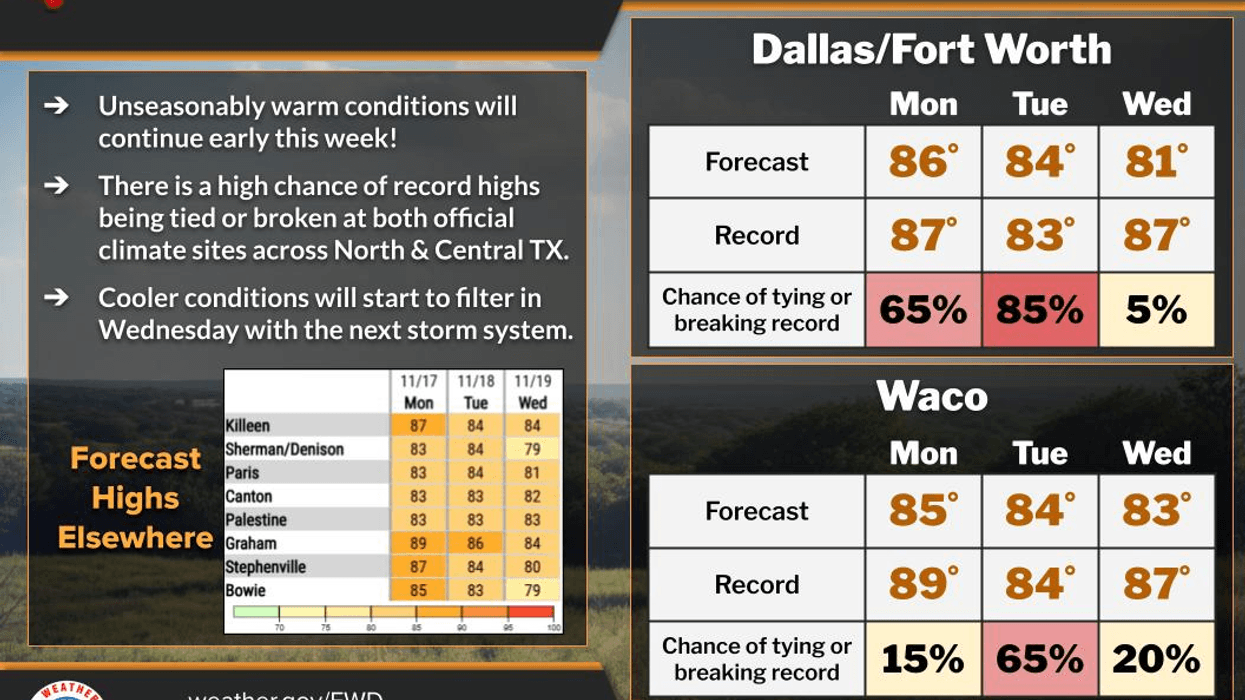
We are waking up to low clouds and temperatures well above average for this time of year, with readings only dropping into the low and mid-60s. Average low temperatures are now falling into the mid-40s. Clouds will break up by late morning, leading to a partly cloudy day today with afternoon highs in the mid to upper 80s. The record high for today is 87 degrees.
Low clouds will return by tomorrow morning, with temperatures only falling into the low to mid-60s again. Partly cloudy conditions will prevail tomorrow afternoon, with readings reaching the mid to upper 80s again. The record high for tomorrow is 83 degrees.
A significant change in the weather is expected on Wednesday as a strong upper-level disturbance moves into the Four Corners area of the western United States. The first wave of energy will arrive Wednesday morning, bringing a few showers to the area, although many will not experience rain. Afternoon highs will reach the low 80s with peaks of sunshine. If the cap breaks Wednesday afternoon, more showers and storms may form during peak heating hours, potentially leading to severe storms with hail and damaging winds being the primary threats. The tornado threat is low but not impossible. Storms should weaken after sunset Wednesday.
The second wave of energy will arrive in the first half of Thursday, producing widespread shower and thunderstorm activity to the west and southwest of DFW. This large area of rain with embedded thunder will slowly move across the area during the day. Some storms may become severe, with small hail and damaging winds being the primary threats. Although unlikely, a weak spin-up tornado cannot be ruled out along the line as it moves through the area in the second half of Thursday. Average rainfall totals are expected to be between two to three inches, with isolated higher totals possible. A flood watch may be issued, but that will be evaluated by the National Weather Service on Wednesday.
A cold front will sweep through the area by early Friday, clearing out just in time for the weekend. Cooler, drier air will filter in, with afternoon highs on Friday reaching the upper 60s. Weekend weather will feature morning lows in the 40s, afternoon highs in the 60s, and dry air briefly filtering in.
Another weather change is expected early next week, with more rain in the forecast. It is still too early to discuss the potential for much colder air to move into the area for Thanksgiving and another blast following that one. Models are trending in that direction, but that will be addressed once we get through these next two events.
Have a great day today and please enjoy the weather when you can, it's the only weather you've got.
7-Day Headlines:
* DFW Airport reached 80 yesterday.
* Morning clouds, afternoon sun through Wednesday.
* Record breaking heat today and Tuesday.
* Scattered showers and strong storms Wednesday.
* Widespread showers and strong storms Thursday. Heavy rain.
* Clearing and cooler this weekend.
* More storms next week.
*Yest Rain: 0.00"; Yest High: 80; Low: 60
*Today's Averages: High: 66; Low: 46
*Record high: 87 (1938, 2013); Record low: 20 (1959)
__________________________________________________________
*November Rain: 0.03"; Deficit:
*2025 Rain: 32.94"; Deficit:
*Sunrise: 7:02am; Sunset: 5:25pm
__________________________________________________________
Monday: Morning clouds, afternoon sun. Breezy. Near record highs (87). High: Mid to upper 80s. Wind: South 10-20 mph.
Monday night: Increasing low clouds. Mild and muggy. Low: Mid to upper 80s. Wind: SSW 10-20 mph.
Tuesday: Morning clouds, afternoon sun. Near record highs (83). Breezy. High: Mid 80s. Wind: SSW 10-20 mph.
Wednesday: Mostly cloudy and mild. Scattered showers and storms. Isolated severe. High: Low 80s.
Thursday: Cloudy and mild. Widespread showers and storms. Heavy rain. Isolated severe storms. High: Mid 70s.
Friday: Morning clouds, afternoon sun. Breezy, with drier air moving in. High: Mid 70s.
Saturday: Sunny and cooler. High: Mid 60s.
Sunday: Partly cloudy and pleasant. High: Low 70s.
LISTEN on the Audacy App
Tell your Smart Speaker to "PLAY 1080 KRLD"
Sign Up to receive our KRLD Insider Newsletter for more news
Follow us on Facebook | Twitter | Instagram | YouTube