Meteorological spring has officially commenced across North Texas. We encourage you to make the most of today, tomorrow, and the majority of Wednesday, as severe weather is anticipated Wednesday night and again from Friday through Saturday. Furthermore, a flooding threat is expected to develop late this weekend and persist into early next week.
Good morning, and welcome to Monday. We hope you had a pleasant weekend. Currently, temperatures range from the low 50s north of Dallas and Fort Worth to low 60s elsewhere. The cold front is expected to stagnate along or just north of the Dallas-Fort Worth area today, resulting in afternoon highs spanning from the 60s north to near 80°F south of DFW. Notably, no precipitation will accompany the stalled front. As the Gulf introduces a substantial amount of moisture in our direction throughout the week, this system will lift back northward this evening.
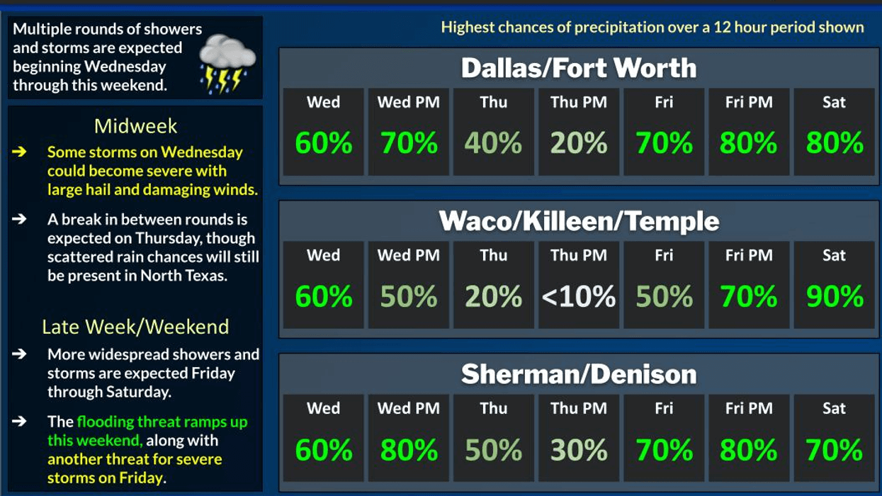
The initial series of upper-level disturbances will commence impacting our weather as early as Wednesday evening. Scattered showers and storms will develop along another front that will become stationary across the area on Wednesday evening. Coupled with ample surface moisture and plenty of instability, this will produce scattered showers and isolated severe storms by Wednesday evening. Currently, the tornado threat appears relatively low, while hail and wind will be the primary concerns. Afternoon highs on Tuesday and Wednesday are expected to reach near 80°F, with plenty of instability and heating available to fuel the storms late Wednesday.
The first wave of rain will move out Thursday morning, giving way to a partly cloudy sky on Thursday afternoon. Afternoon highs will reach the mid-to-upper 70s.
Most of Friday will be pleasant, with highs approaching 80°F under a partly cloudy sky. However, by Friday night, a cold front will approach the area from the northwest, leading to scattered showers and isolated severe storms across the area. Although coverage may not be extensive, it only takes one or two storms to cause significant disruptions in your neighborhood. As the week progresses, we will refine our predictions regarding timing, threats, and precipitation totals.
This front is expected to stagnate near North Texas on Saturday and hover in the area on Sunday and Monday. Upper-level disturbances will ride along this boundary from Saturday through early next week, producing waves of very heavy rain. Although the severe weather threat will persist on Saturday, as the front shifts south of us on Sunday, waves of heavy rain will continue to affect the area.
Currently, the severity appears relatively low from Sunday through early next week, but this depends on the front's stagnation point. Flash flooding will become a significant concern throughout this period. Some data suggests that North Texas may receive 5-8 inches of rain before the situation resolves by Tuesday of next week. Please stay tuned for updates on the speed and track of these upper-level disturbances, the position of the cold front, the severity of the storms, and precipitation amounts. Temperatures will remain in the 60s on Sunday and Monday of next week, as the front shifts south of the area.
A complex weather scenario is unfolding, and we urge you to remain weather-aware. Stay informed throughout the week via News Radio 1080 KRLD and follow our Facebook pages for updates.
7-Day Headlines:
* DFW Airport reached 81 yesterday.
* A cold front bisects north Texas today.
* Front lifts north tonight. No rain with it.
* Tuesday and most of Wednesday are quiet.
* Severe weather threat late Wednesday, Friday and Saturday.
* Flooding threat starts this weekend.
* 3.00" rain deficit will be erased.
*Yest Rain: 0.00"; Yest High: 81; Low: 61
*Today's Averages: High: 64; Low: 44
*Record high: 90 (1901); Record low 15 (1980)
*March rain: 0.00"; Deficit:
*2026 Rain: 2.24"; Snow: 2.4" Deficit:
*Sunrise: 6:53am; Sunset: 6:27pm
Monday: Mostly sunny and mild. Cold front bisects north Texas. High: 65- 80. Wind: Variable: 5-10 mph.
Monday night: Increasing clouds, mild and muggy. Low: Low 60s. Wind: South 10-20 mph.
Tuesday: Morning clouds, afternoon sun. Windy and mild. High: Low 80s. Wind: South 15-25, G30 mph.
Wednesday: Increasing clouds, breezy and mild. Scattered severe storms towards evening. Threats: Hail and wind. High: Near 80.
Thursday: Morning showers and storms, then partly cloudy, breezy and mild. High: Mid to upper 70s.
Friday: Mostly to partly cloudy, windy and warm. Scattered severe storms late. High: Near 80.
Weekend: Mostly cloudy, breezy and mild. Waves of heavy rain. Some may be severe on Saturday. Highs: 70s to 60s.
LISTEN on the Audacy App
Tell your Smart Speaker to "PLAY 1080 KRLD"
Sign Up to receive our KRLD Insider Newsletter for more news
Follow us on Facebook | Twitter | Instagram | YouTube