


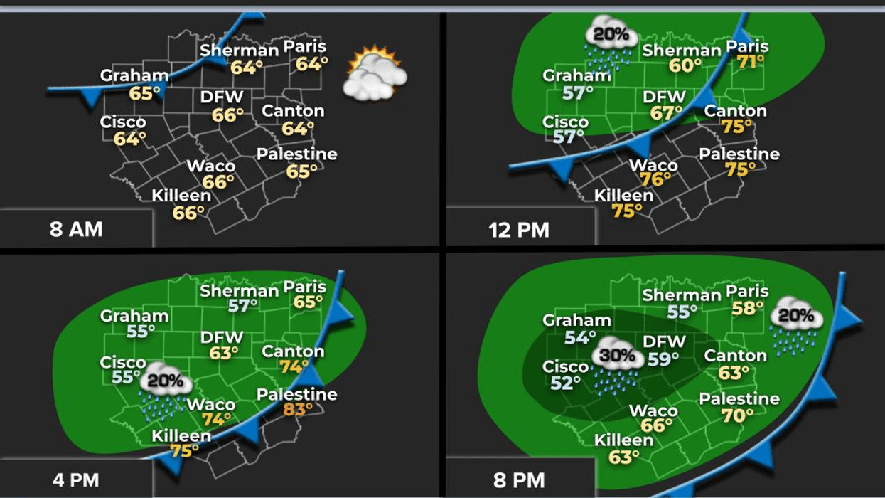
Be sure to grab your jacket and umbrella as you head out the door this morning. A fast-moving cold front will arrive shortly after noon, bringing sharply cooler temperatures and a threat for showers later this afternoon.
Good morning. We have finally made it to Friday. Thankfully, the week has come to a close. I hope your week has been productive and that you enjoyed the warm weather. We are waking up to temperatures in the upper 60s to near 70 degrees here on this late March morning. However, please do not let your guard down.
As I stated earlier, please ensure you grab a jacket and your umbrella as you head to work or school this morning. I am tracking a windy cold front approximately 7 hours away from DFW airport. Temperatures will warm to near 80 degrees by lunchtime but fall sharply into the 50s late this afternoon with north winds gusting up to 35 mph. That is why you will need your jacket later today. I am also tracking an upper-level disturbance following the front that will bring some showers to the area late this afternoon through midnight tonight. Rainfall totals will be very light.
By tomorrow morning, temperatures will have settled into the upper 40s to low 50s with considerable cloudiness. These clouds will slowly erode by the late afternoon. However, with the north wind gusting up to 20 mph and plenty of cloud cover, temperatures will struggle to rise above the low 60s. Areas northwest of us may jump into the mid-60s.
The skies will clear overnight into Sunday morning, with temperatures falling back into the low 50s. The cold front will lift back to the north by early afternoon, allowing temperatures to jump up close to 80 degrees.
South winds will pick up on Monday and Tuesday, with morning lows jumping back up into the 60s and afternoon highs well up into the 80s.
Our next weather system will arrive late Tuesday into Wednesday and may even linger into Thursday as a slow-moving cold front sags into the area. Temperatures will fall into the 70s for highs on Wednesday and Thursday, with a chance for showers and storms. It is still too early to tell if anything will be severe. As of now, the model data suggests we will be on the southern fringes of the heavy rain and severe weather threat. Stay tuned as the system is still over the open waters of the Pacific.
April will have arrived by then, and as we know, severe weather starts to ramp up. I will be watching and keeping you posted as we approach the middle of next week.
Have a great day today, an awesome weekend, and enjoy the weather when you can; it is the only weather you have got!
7-Day Headlines:
- DFW Airport reached 87 yesterday.
- Noon cold front, increasing clouds, windy and colder.
- Scattered showers this evening.
- A cool and cloudy Saturday. Clearing by dinner.
- A rapid warm up Sunday -Tuesday.
- Rain chances may increase by Late Tuesday - early Thursday.
Almanac:
- Yest Rain: 000”; Yest High: 87; Low: 67
- Today’s Averages: High: 72; Low: 51
- Record high: 96 (1956); Record low 23 (1955)
- March rain: 2.91”; Surplus: 0.12”
- 2026 Rain: 5.15”; Snow: 2.4” Deficit: <2.93”>
- Sunrise: 7:21am; Sunset: 7:46pm
7-Day Forecast:
Friday: Increasing clouds. Noonish cold front. Windy and cooler, with a few showers by late afternoon. High: Upper 70s early, falling into the 50s by late afternoon. South to north 15-25, G35 mph.
Friday night: Cloudy, windy and cool. Scattered showers through 2am. Low: Near 50. Wind: North 15-25, G20 mph.
Saturday: Cloudy and cool. Decreasing clouds by late afternoon. Less wind. High: Low 60s.
Sunday: Sunny, breezy and perfect! High: Near 80.
Monday: Sunny, windy, and warm. High: Low 80s.
Tuesday: Increasing clouds by afternoon. A cold front by late evening brings scattered showers and storms with it. Low:65; High: Mid to upper 80s.
Wednesday: Cloudy and cool. Scattered showers and isolated storms. Low: 68; High: 70.
Thursday: Morning showers, then mostly to partly cloudy and mild. Low:60; High: Low 70s.


