


The fog and drizzle have moved out of North Texas and near-freezing or slightly below temperatures have returned. A significant amount of rainfall is heading to North Texas on Wednesday, with isolated severe weather possible. The latter part of the 7-day forecast looks pleasant, with spring-like temperatures arriving this weekend.
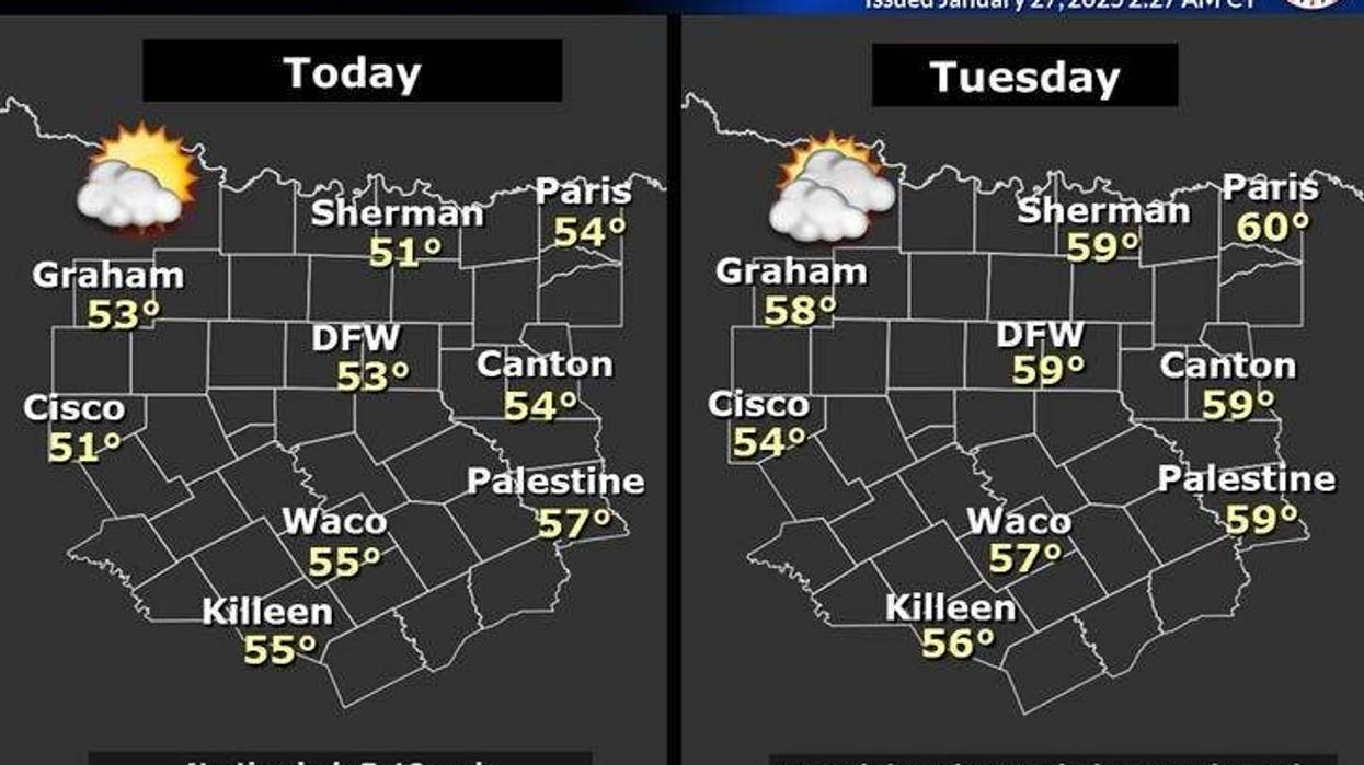
Monday began with a mostly clear sky across much of the area and temperatures ranging from the upper 20s to mid-30s. Afternoon highs will reach the low 50s. The average high temperature has risen to 58 degrees.
Clouds will increase overnight, with morning lows in the low to mid-40s. Tuesday will be cloudy and slightly warmer, with highs in the mid-to-upper 50s, which is average for this time of year.
An area of low pressure in the upper levels of the atmosphere, which has been trapped across the southwestern United States, will begin to move on Wednesday. The first wave of energy will arrive in the morning, producing scattered showers throughout the day. Afternoon highs will reach the mid-to-upper 50s again.
The main system will move across the Panhandle and into the South Plains on Thursday. Widespread heavy rain will break out late Wednesday and continue through the first half of Thursday. Some rain may be heavy at times, accompanied by lightning and thunder. There is a chance of storm warnings for damaging wind. There may also be some small hail and stronger storms. Average rainfall totals will range between 2 and 3 inches across the area, with isolated higher totals possible.
North Texas could potentially be dealing with record rainfall for Jan. 30, which is Thursday. The record is 1.24 inches back in 1982. Everything will move out by the second half of the day, with rapid clearing behind the Pacific front.
If your favorite season is spring, you will love what is going to happen from Friday through the weekend. Plenty of sunshine is expected throughout the period, with low 60s on Friday, near 70 on Saturday, and mid-70s by Sunday.
 National Weather Service
7-Day Headlines
* DFW Airport reached 50 on Sunday.
* A chilly start, some sunshine today. Cool.
* Increasing clouds, the sun comes back out Friday.
* Waves of rain on Wednesday and Thursday. Isolated severe for wind.
* Widespread 2-3 inches of rain. Isolated higher amounts
* Very warm this weekend. 15+ degrees above average (58 degrees).
_____________________________________________________
*Sunday Rain: Trace; Sunday High: 50; Low: 42
*Monday's Averages: High: 58; Low: 37
*Record high: 81 (1975); Record low: 12 (1963)
________________________________________________________
*January Rain: 1.56"; Deficit:
*2025 Rain: 1.56; Snow: 2.30"; Deficit:
*Sunrise: 7:26am; Sunset: 5:56pm
________________________________________________________
Monday: Partly cloudy and cool. High: Low 50s. Wind: North 5-10 mph.
Monday night: Increasing clouds, not as cold. Low: Low to mid-40s. Wind: Calm.
Tomorrow: Cloudy and seasonable. High: Mid to upper 50s. Wind: South 5 mph.
Wednesday: Cloudy and cool. Off and on showers. Heavier towards midnight. High: Mid to upper 50s.
Thursday: Cloudy and mild, with widespread showers and thunderstorms. Isolated severe through mid-afternoon. Threats: Damaging wind and small hail. High: Low 60s.
Friday: Sunny and mild. High: Near 70.
Saturday: Sunny and mild. High: Near 70.
Sunday: Mostly sunny and warm. High: Low to mid-70s.
 National Weather Service
LISTEN on the Audacy App
Tell your Smart Speaker to "PLAY 1080 KRLD"
Sign Up to receive our KRLD Insider Newsletter for more news
Follow us on Facebook | Twitter | Instagram | YouTube


