


It's the end of April, early May, which means it's time to stay weather aware. There will be several chances of strong to severe storms in the forecast over the next 48 hours across North Texas.
Tuesday began with mild and muggy conditions with low cloud cover, breezy conditions, and temperatures in the low 70s.
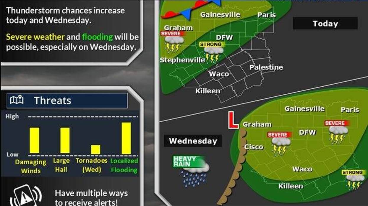
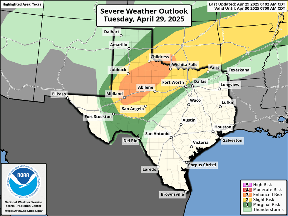
Gulf moisture will continue to move northbound throughout Tuesday as the dry line rejuvenates to the west. Through the afternoon, widespread supercells will develop along the dry line and move east-northeast through the evening. These individual cells will likely form a small line of severe storms that will impact areas north of Interstate 30 late Tuesday. Damaging winds, large hail, and isolated tornadoes are potential threats. Heavy rain is also a concern for Red River counties, where a Flood Watch is in effect until Thursday morning. Afternoon highs will reach the low 80s.
 NOAA
NOAA
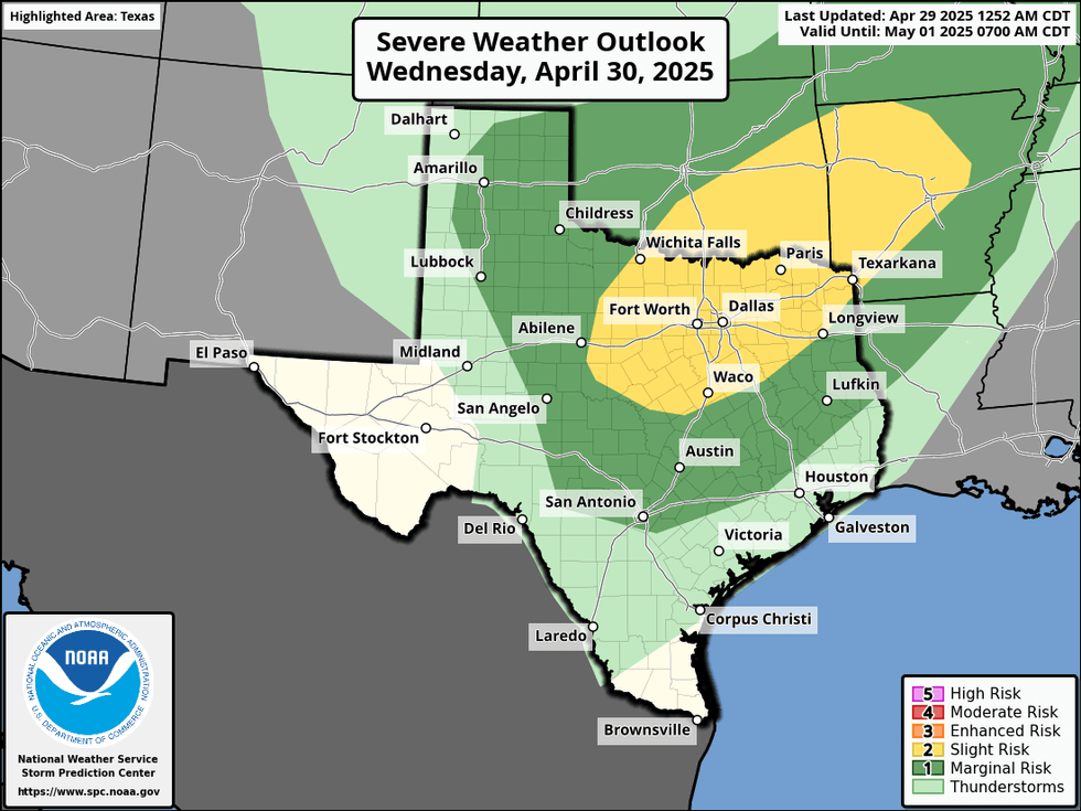
The atmosphere will rejuvenate itself during the first half of Wednesday, with only a few showers present in the morning. Low temperatures will again be in the low 70s, with afternoon highs reaching the low 80s. The dry line west of DFW will become active again in the afternoon, leading to the development of scattered supercells. These storms will bring large hail, damaging winds, and a few tornadoes. The storms will move east through the late afternoon and evening, eventually forming a line of storms that will move through the area and head southeast of North Texas after sunset.
 NOAA
NOAA
A weak cold front will move through Wednesday evening, taking the storms with it. Thursday will be dry, with slightly lower humidity and afternoon highs reaching the low to mid-80s.
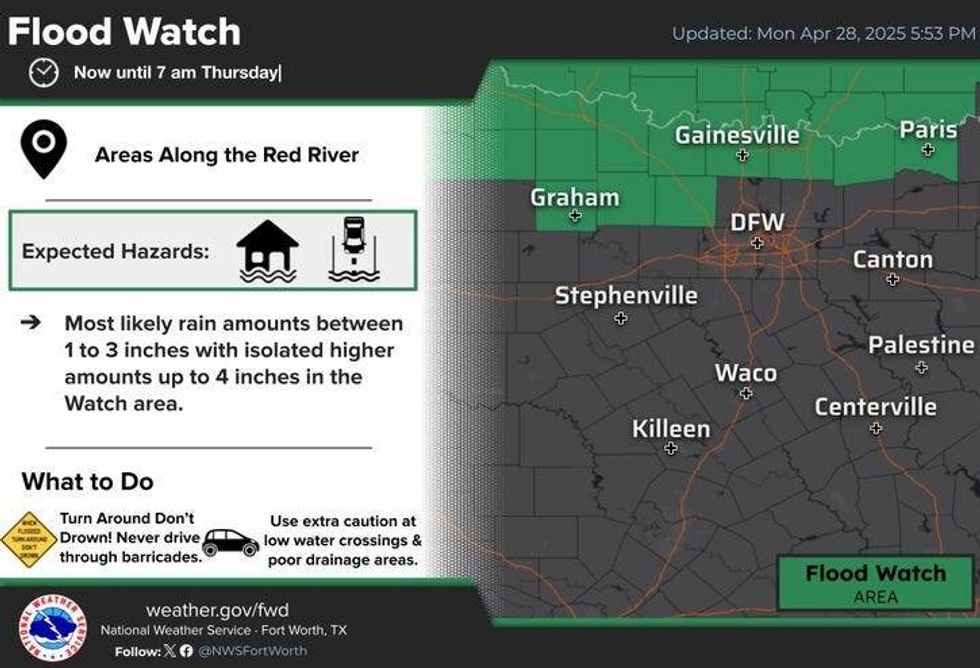 Flood Watch for parts of North Texas through Thursday morning.National Weather Service
The atmosphere will become active again Thursday night into the first half of Friday as another cold front moves through the area. Severe weather is possible throughout the day, with temperatures cooler and readings in the low 70s. The storm threat will shift south of us by late afternoon and evening.
The forecast looks decent for the next week, but it depends on where the cold front stalls. One thing is certain: areas of Texas that need rain, such as the Hill Country, will benefit from this stalled front over the weekend. Temperatures will hover in the 70s.
We will start off quiet next week, but more active weather is possible by the middle of next week.
7-Day Headlines
DFW hit 81 degrees on Monday.
Fairly quiet on Tuesday, severe storms north of I-30 late this evening.
Scattered severe storms are expected on Wednesday. Flood Watch to the north.
Threats: Large hail, damaging wind, isolated tornadoes. Stronger/severe storms Friday.
Cooler temperatures this weekend. Isolated showers.
*Monday Rain: 0.00"; Monday High: 81, Low: 72
*Tuesday's Averages: High: 79; Low: 59
*Record high: 97 (1909): Record low: 41 (1908)
_________________________________________________________
*April Rain: 2.82"; Deficit: 0.14"
*2025 Rain: 11.53"; Deficit: 0.02"
*Sunrise: 6:41am; Sunset: 8:10pm
_________________________________________________________
Tuesday: Mostly cloudy, breezy, and humid. High: Low 80s. Wind: South 15-25 mph.
Tuesday night: Scattered showers and isolated severe storms, mainly north of I-30 this evening. Breezy, mild, and humid. Low: Upper 60s. South 15-25 mph.
Wednesday: Morning clouds, peeks of afternoon sun. Scattered afternoon showers and severe storms. Threats: Large hail, damaging wind, isolated tornadoes, flooding (north). High: Low to mid-80s. Wind: South 15-25 mph.
Thursday: Partly cloudy, warm, and humid. High: Low to mid-80s.
Friday: Scattered showers and storms, some severe. Afternoon cold front. High: Mid 70s.
Saturday: Mostly to partly cloudy and cooler. Scattered showers, especially south of DFW. High: Near 70.
Sunday: Partly cloudy and pleasant. High: Mid to upper 70s.
Monday: Mostly cloudy and nice. High: Low 80s.
LISTEN on the Audacy App
Tell your Smart Speaker to "PLAY 1080 KRLD"
Follow us on Facebook | Twitter | Instagram | YouTube


