



**SLOW WEATHER CHANGES ARE COMING TO NORTH TEXAS OVER THE NEXT 7 DAYS!**
Good morning, everyone! I hope you've had a great workweek so far!
We don't have much going on across North Texas right now. Skies are mainly clear, and temperatures have once again fallen into the upper 50s to low 60s. That's been the weather story for much of the week, and there is no rain on radar.
However, that could change by Friday as moisture from what remains of Tropical Storm Vance moves across Mexico and into Texas. Right now, it looks like the bulk of the measurable rainfall will stay west of the Dallas-Fort Worth area from late Thursday through Saturday morning.
We'll likely see a few showers move into our area from the southwest on Friday. At this point, I'm expecting rainfall totals to remain below a quarter of an inch for most locations east of Interstate 35W. Amounts will gradually increase farther west, especially across the Texas Panhandle, South Plains, and western portions of the state.
Those western areas are heading toward a much wetter end to October. Here in North Texas, we received plenty of rain during the first part of the month, which has kept our monthly totals close to average. We'll likely finish October near average, with rain at the beginning and potentially more at the end. Personally, I'd rather see some rain every week or so instead of getting it all at once!
**YOUR NORTH TEXAS FORECAST**
Temperatures will remain warmer than normal over the next several days, with highs in the low 80s today and near 80 on Thursday.
Friday will be cooler, with clouds and a few showers keeping temperatures in the 70s throughout the day.
By Saturday, most of the rain should be gone, although a few leftover showers could linger during the first half of Halloween. The good news for trick-or-treaters is that skies should clear just in time for the evening, with temperatures settling into the low 70s after sunset.
Highs will generally be in the mid to upper 70s Saturday, depending on cloud cover. We'll approach 80 degrees again Sunday and Monday before our next weather system arrives.
**DON'T FORGET ABOUT THE TIME CHANGE!**
We're currently seeing sunset around 6:30 p.m., but by Sunday evening, sunset will occur around 5:30 p.m. Sunrise will also shift from approximately 7:40 a.m. to 6:40 a.m. as daylight saving time comes to an end this weekend.
That means we'll have brighter mornings but darker evenings. Remember to adjust your clocks before heading into Sunday!
**OUR NEXT COLD FRONT ARRIVES NEXT WEEK!**
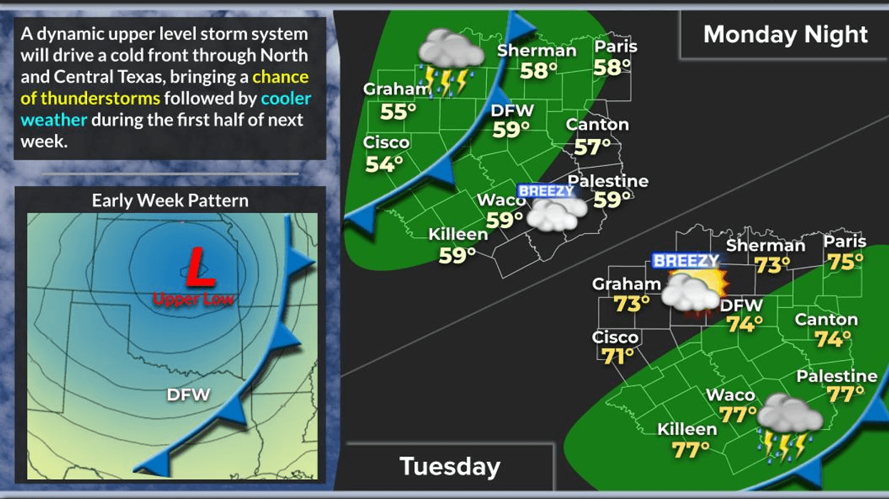
Our next weather maker is expected to arrive late Monday into Tuesday, bringing a cold front and another chance for showers and thunderstorms.
It's still too early to pinpoint exactly where storms will develop or how strong they could become. One possibility is that showers and storms form northwest of the Dallas-Fort Worth area, then move through overnight into Tuesday morning before continuing toward the Texas coast by Tuesday evening.
We'll keep a close eye on this system as we get closer to next week. I'll be on the air Monday to give everyone an update on the timing and potential threat levels.
Behind the front, cooler air will move into North Texas, especially Wednesday and Thursday. Temperatures could fall slightly below average, with highs in the upper 60s to low 70s and morning lows in the 50s. Some outlying locations could even dip into the 40s.
And there's a possibility of another, potentially stronger cold front after that. We'll keep watching!
Have a great day, everyone! Please like and share this post to help keep everyone across North Texas weather aware.
And remember to enjoy the weather when you can. It's the only weather you've got!
7-Day Headlines:
- DFW Airport hit 83 degrees on Tuesday
- Warm and dry Wednesday and Thursday
- Increasing rain chances late Friday into Halloween afternoon
- Trick-or-Treaters should be dry. Near 70 degrees.
- Daylight saving time ends early Sunday morning
- Warming up Sunday and Monday
- Late Monday cold front, watching out for strong storms
- Download our AUDACY app! Listen to KRLD LIVE at home or at work
Almanac:
- Yest Rain: 0.00”; Yest High: 83; Low: 64
- Today’s Averages: High: 74; Low: 53
- Record high: 90 (1938); Record low 30 (1925)
- October rain: 3.94” ”; Surplus: 0.16”
- 2026 Rain: 26.72”; Snow: 2.4”; Deficit: <4.33””>
- Sunrise: 7:44am; Sunset: 6:40pm
Forecast:
Wednesday: Partly cloudy and warm. Isolated showers south of DFW. High: Low 80s. Wind: South 10-20 mph.
Wednesday night: Partly cloudy and comfortable. Low: Low to mid 60s.
Thursday: Increasing clouds and warm. Isolated showers (west) by evening.. High: Near 80.
Friday: Cloudy and mild. Scattered showers and isolated storms (mainly west of DFW) High: Mid 70s.
Halloween: Scattered showers and isolated storms, then partly cloudy by evening. High: Low 70s.
Sunday: Mostly sunny and warmer. High: Near 80.
Monday: Increasing clouds and warm. Scattered showers and storms late. High: Mid 80s.
Tuesday: Mostly cloudy, windy and cooler. Areas of light rain/drizzle. High: Mid 60s.
LISTEN on the Audacy App
Tell your Smart Speaker to "PLAY 1080 KRLD"
Sign Up to receive our KRLD Insider Newsletter for more news