



A COUPLE OF PLEASANT DAYS BEFORE COLDER WEATHER RETURNS TO NORTH TEXAS!
We have a couple of pleasant days ahead before two cold fronts move through North Texas, one early Sunday and another late Tuesday into Wednesday. Both fronts will bring temperatures below seasonal averages, along with a very slight chance of some light rain. Unfortunately, the possibility of widespread, heavy rainfall across North Texas toward the end of Thanksgiving week is looking much less promising than it did a few days ago. That could still change, and I'll keep watching things for you.
Good morning, everyone! Welcome to Friday. I hope you've had a great workweek. Many of the kids will be out of school next week, and I wish I could say the same! I'll be taking Thanksgiving Day and Friday off, but I know many of you may be traveling early to get a head start on the holiday week.
The good news is that travel conditions across most of Texas should be just fine. I'm not expecting any significant rainfall across the state, with the exception of Deep South Texas, where showers and storms are possible from south of Victoria toward Corpus Christi and Port Aransas Sunday night into early Monday.
**TODAY AND SATURDAY**
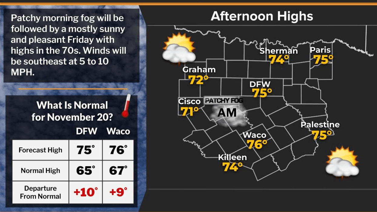
A chilly start this morning with temperatures in the upper 40s to lower 50s, but we'll warm up nicely this afternoon. Highs should reach around 74 degrees today and again on Saturday.
Saturday will be a little breezier as south winds increase, with gusts approaching 20 mph.
Heading out to high school football tonight? Weather conditions should be quiet. Temperatures will gradually fall into the 60s by the end of the games, so you'll want to have a light jacket handy.
**SUNDAY AND MONDAY**
Our first cold front will move into the Texas Panhandle Saturday evening before pushing through the rest of the state on Sunday. Sunday will be cooler across North Texas, with partly cloudy skies and perhaps a few sprinkles along the front before noon. Most locations should remain dry. Afternoon highs will only reach the low to mid-60s, with north winds gusting around 20 mph.
Monday will be cooler still, with afternoon highs topping out in the upper 50s.
**TUESDAY THROUGH THANKSGIVING**
Another cold front is expected to arrive late Tuesday into early Wednesday, bringing another shot of colder air.
An upper-level disturbance will accompany this system, but disturbances moving in from the Northwest are typically moisture-starved. I can't rule out a few scattered showers along the front late Tuesday or early Wednesday, but most locations will likely receive less than a tenth of an inch of rain.
A change in the track of this system
could determine whether we see a little more rainfall around Thanksgiving, so this is something I'll continue monitoring.
Otherwise, expect breezy and colder conditions, with afternoon highs generally in the 50s Tuesday, Wednesday and Thanksgiving Day.
**HOW COLD WILL IT GET?**
Morning lows Wednesday, Thursday and Friday will drop into the 30s across much of North Texas.
Will we see our first freeze of the season? I doubt it here in the Metroplex, but temperatures could flirt with the freezing mark along the Red River and in some sheltered areas away from the cities, especially Thursday and Friday mornings.
For those wondering, the average date of our first freeze is November 22.
Have a fantastic Friday and a wonderful weekend! If you're heading out of town early for Thanksgiving, safe travels.
Thank you for following my page. Please remember to LIKE and SHARE to help keep North Texans weather aware!
7-Day Headlines:
- DFW Airport hit 74 degrees on Thursday.
- Patchy fog this morning (mainly west of DFW)
- Perfect weather today and Saturday
- Sunday morning cold front brings a few sprinkles
- MUCH colder next week
- Watching Tuesday nights 2nd cold front
- Some rain early Wednesday. Wet snowflakes well NW of DFW?
- Download our AUDACY app! Listen to KRLD LIVE at home or at work
Almanac:
- Yest Rain: 0.00”; Yest High: 74; Low: 48
- Today’s Averages: High: 65; Low: 45
- Record high: 84 (2007); Record low 23 (1937)
- November rain: 0.60”; Deficit: <1.13”>
- 2026 Rain: 27.37”; Snow: 2.4”; Deficit: <6.00”>
- Sunrise: 7:04am; Sunset: 5:24pm
Forecast:
Friday: Morning patchy fog (west of DFW), then sunny and perfect! High: Mid 70s. WInd: SSE 5 mph.
Friday night: Clear and cool. Low: Low to mid 50s. Wind: SSE 5-10 mph.
Saturday: Mostly sunny and pleasant. High: Mid 70s. Wind:SSE 15-25, G30 mph.
Sunday: Early morning cold front. A few sprinkles, especially north of Hwy 380.. Windy and cooler. High: Low to mid 60s.
Monday: Mostly sunny and cool. High: Low 60s.
Tuesday: Mostly sunny, increasing clouds, cold front by evening. Slight chance of light rain. Wet snow flakes well northwest of DFW overnight? HMMMMMMMMMMM! High: Low 60s.
Wednesday: Morning showers/wet snow NW of DFW? Afternoon sun, breezy and chilly. High: Low 50s.
Thanksgiving: Sunny and cool. Lows: 35-40; Highs: Low to mid 50s.
LISTEN on the Audacy App
Tell your Smart Speaker to "PLAY 1080 KRLD"
Sign Up to receive our KRLD Insider Newsletter for more news