Chilly mornings and mild afternoons are expected throughout the weekend, with a slight chance of showers and isolated storms late Sunday. However, a more significant threat of strong and severe storms is anticipated late Monday into Tuesday, followed by cooler temperatures.
A high-pressure system is currently settled overhead, resulting in temperatures ranging from the mid-30s to mid-40s. Although it may be chilly in the morning, temperatures are expected to warm up significantly by the afternoon, reaching the mid-70s with ample sunshine.
The weekend is looking fantastic, with another weak front moving in tomorrow, keeping mornings cool and afternoons mild. Temperatures will start off in the mid-40s tomorrow morning, with plenty of sunshine during the day and temperatures reaching the mid-70s.
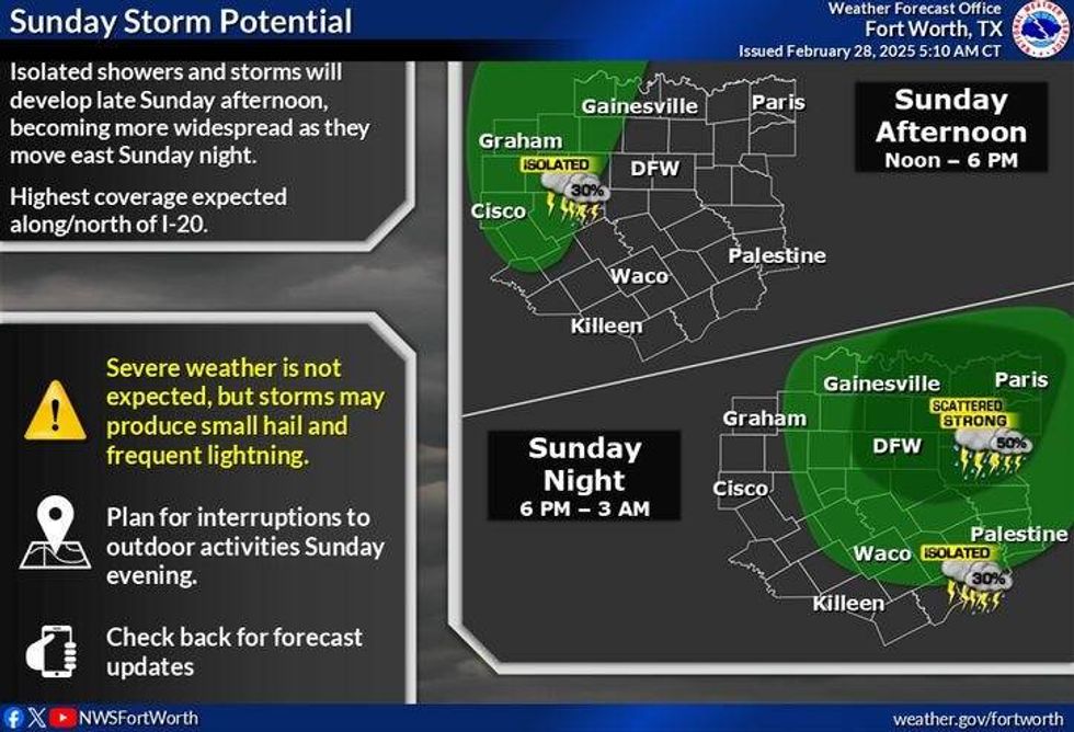
A south wind will return on Sunday, warming temperatures into the upper 70s. By Sunday evening, a fast-moving system will bring a slight chance of showers and isolated thunderstorms to the area. Although the chances are relatively low, residents in the Arklatex can expect a higher likelihood of precipitation.
 NWS
NWS
As we move into next week, temperatures will be warm and windy, with morning low clouds giving way to afternoon sunshine and daytime highs reaching the low 80s. However, by Monday night, a powerful storm system will exit the Rockies and move across the South Central Plains states, bringing widespread shower and thunderstorm activity to the Dallas-Fort Worth area. These storms will continue to move east and intensify through the early morning hours of Tuesday, with the worst of the weather expected east of Central Expressway and Interstate 45. Large hail and damaging winds will be the primary threats initially.
As the storms move into Arkansas and Louisiana, tornadoes, large hail, and damaging winds will become increasingly likely. Residents in Arkansas, Louisiana, Western Tennessee, Mississippi, Alabama, and even Atlanta should closely monitor the weather forecast on Tuesday and Wednesday. There is still time to refine the severe weather threat, and adjustments will be made as necessary.
Behind the system and dryline on Tuesday afternoon, strong westerly winds will gust over 40 mph, with afternoon highs reaching the upper 70s. A high grass fire danger is expected west of Fort Worth.
Our next cold front will arrive early Wednesday morning, bringing wind and cooler temperatures, but not excessively cold for this time of year. Sunny skies are expected on Wednesday and Thursday, with temperatures reaching 60 and 63 degrees, respectively.
7-Day Headlines:
* DFW Airport reached 71 yesterday.
* A chilly start this morning.
* Most of the weekend looks beautiful.
* Slight chance of showers and storms late Sunday.
* A warm start to the week.
* Strong to severe storms Late Monday night into noon Tuesday.
* Cooler Wednesday and Thursday.
______________________________
*Yest Rain: 0.0o"; Yest High: 71; Low: 52
*Today's Averages: High: 64; Low: 44
*Record high: 88 (1932); Record low: 19 (1962)
_______________________________
*February Rain: 1.34"; Deficit:
*2025 Rain: 7:04"; Surplus: 1.87"
*Sunrise: 6:57am; Sunset: 6:25pm
________________________________
Today: Sunny and pleasant. High: Mid 70s. Wind: SW 5-10 mph.
Tonight: Clear and seasonable. Low: Mid 40s. Wind: NW 5-10 mph.
Tomorrow: Sunny and perfect again. Backdoor WEAK cold front. High: Mid 70s. Wind: NW 5-10 mph.
Sunday: Increasing clouds late. Chance for showers and storms towards evening. Better chances NE of DFW. High: Mid to upper 70s.
Monday: Morning clouds, afternoon sunshine, breezy and warm. Scattered showers and storms late. Some strong. High: Low 80s.
Tuesday: Morning showers and storms, some severe. Threats: Hail and wind. Then decreasing clouds, VERY windy and mild. WInd gusts 40+ mph. High: Upper 70s.
Wednesday: Sunny, windy and cooler. High: Near 60.
Thursday: Sunny, continued cool. High: Low 60s
LISTEN on the Audacy App
Tell your Smart Speaker to "PLAY 1080 KRLD"
Sign Up to receive our KRLD Insider Newsletter for more news
Follow us on Facebook | Twitter | Instagram | YouTube