Clouds, cold and blustery conditions with a few showers today and possibly some wet snow mixing in with the showers north and east of DFW this evening, A sunny but cool weekend, more rain coming late Monday into the 1st half of Valentine's Day, and a slight chance of rain late Wednesday into early Thursday, and then turning cold again. Those are your many weather stories over the next 7 days.
We're waking up to a blustery morning across north Texas. Clouds, a few showers, and temperatures have dropped into the low to mid forties. Factor in the gusty northerly wind and it feels like it's in the low to mid thirties. Bundle up!
Clouds will stick around today, so will the wind and the colder temperatures. We hover in the low to mid forties all day long! Windchills will remain in the thirties, as a few showers dot the area, especially east and south of DFW.
 National Weather Service - Fort Worth
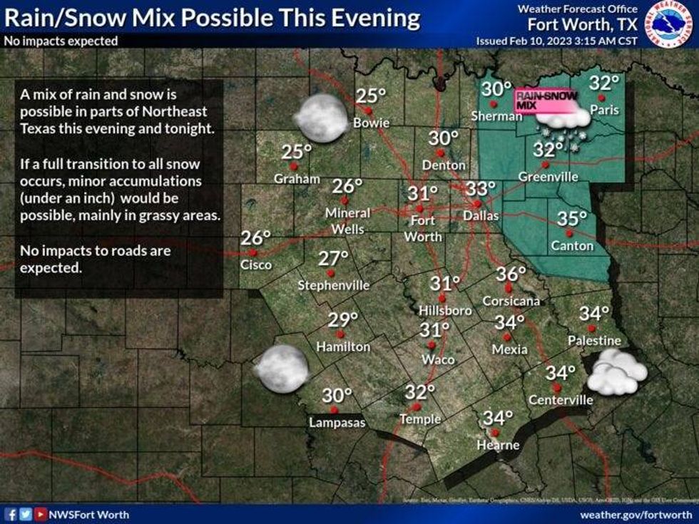
Slow clearing will take place overnight tonight from west to east, with a slight chance of some rain mixing in with some wet snow northeast of DFW. No accumulations are expected. Temperatures will fall into the mid twenties to the west in Fort Worth, low thirties in DFW, and the mid thirties in east Texas.
 National Weather Service - Fort Worth
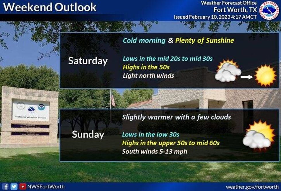
Sunshine returns this weekend, but it will stay cool. There will be less wind on Saturday with highs in the low fifties. South winds return Sunday with readings in the upper fifties.
More weather changes are coming next week. Clouds will increase Monday as we warm into the low to mid sixties. A south wind will gust as high as 30 mph. Clouds will thicken Monday night with rain moving in after midnight into Valentine's Day morning. Widespread rain will continue through the early to mid afternoon, but things should clear up just in time for Valentine's Day dinner! Afternoon highs will hover in the low to mid sixties all day.
Wednesday looks nice and dry, but windy. High temperatures will jump into the low seventies.
Our next weather change arrives on Thursday. A few showers are possible early Thursday morning, it will then turn windy and colder during the day as temperatures fall through the forties. It'll stay cool through the end of the week.
*Yest Rain: 0.00"; High: 62; Low: 39
*Today's Averages: High: 60; Low: 39
*Record high: 85 (1954); Record low: 15 (2011)
*February Rain: 2.90"; Surplus: 2.16"
*2023 Rain: 4.28"; Surplus: 1.01"
*Sunrise: 7:16am; Sunset: 6:09pm
Today: Cloudy, windy and chilly. A few showers. High: Mid 40s. Wind: Shifting NNW 15-25 mph.
Tonight: Mostly cloudy to a clear sky west of I-35W and cold. A few sprinkles early, a light rain/snow mix north and east of DFW. Low: 25-33. Wind: NNW 10-15 mph.
Tomorrow: Sunny and cool. High: Low 50s.. Wind: NW 5-10 mph.
Sunday: Sunny and seasonable. High: Upper 50s.
Monday: Increasing clouds, breezy and mild. Chance of showers towards midnight. High: Low 60s.
Valentines Day: Cloudy and cool. Good chance of showers and isolated storms. Ending by afternoon. High: Mid 60s.
Wednesday: Increasing clouds, windy and warmer. SHowers by late evening. High: Near 70.
Thursday: Slight chance of rain, turning windy and colder. High: Upper 50s early, 40s by evening.

LISTEN on the Audacy App
Tell your Smart Speaker to "PLAY 1080 KRLD"
Sign Up and Follow NewsRadio 1080 KRLD