


Here are your weather stories over the next 7 days... Lots of clouds and cool temperatures through Saturday, heavy rain just south and east of DFW, a gorgeous Easter Sunday, staying cool through early next week with a slight chance of showers on Monday, and a slow warm up through Thursday.
We're waking up to considerable cloudiness and seasonable temperatures for this time of the year, with the exception of the Red River area where readings have fallen into the low to mid forties under a clear sky. We have very dry air in place right now acting like a brick wall, inhibiting the rain to our south from moving into our area. As of now, it looks like the majority of the rain will stay south of Interstate 20 through early afternoon Saturday. However, a few showers could start to sneak into our area after midnight tonight through noon tomorrow, but precipitation totals will be less than 0.05".
Lows tonight will be in the low to mid fifties, with highs tomorrow in the mid two upper sixties with a slow decrease in clouds by evening.
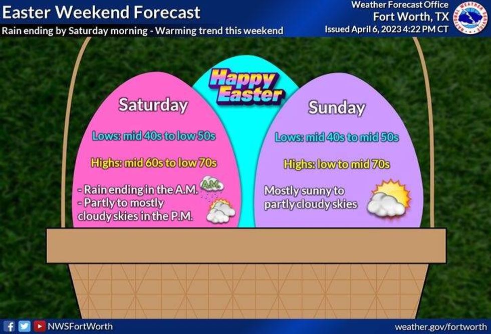
A partly cloudy sky will greet you Easter morning, with low temperatures in the mid fifties... Afternoon highs will approach seventy degrees.
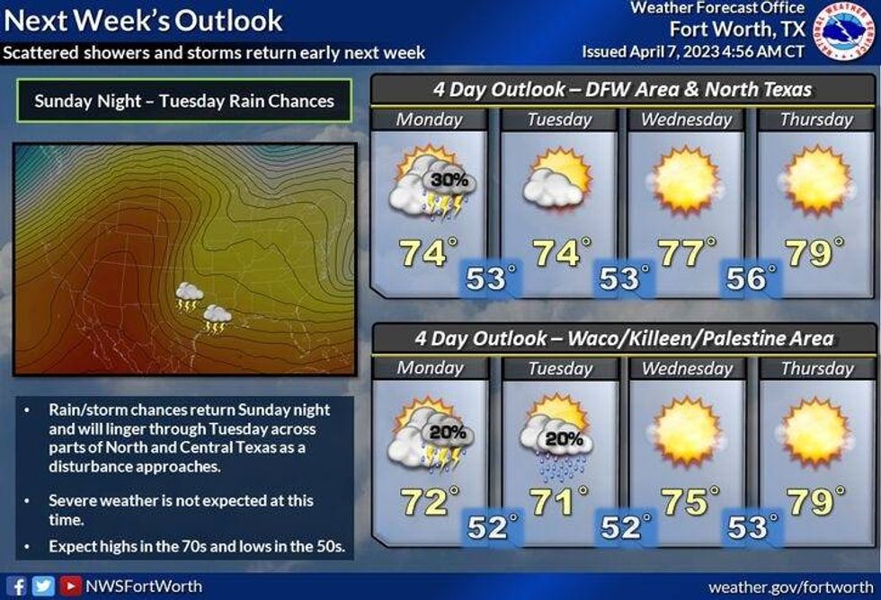
By Monday, clouds will increase again with a slight chance of showers. High temperatures will remain on the cool side with readings in the low seventies.
Tuesday and Wednesday look nice! Plenty of sunshine with highs in the mid seventies...it'll approach eighty degrees by Thursday.
Have a terrific Easter and Passover weekend and please enjoy the weather when you can, It's the only weather you've got!
 National Weather Service - Fort Worth
7-Day Headlines:
* DFW reached 59 degrees yesterday. .
* Below average temperatures (75 is avg.) through Easter.
* Heavy rain stays south and east of DFW.
* DFW rain total less than 0.10", nothing to our north.
* A very slow warm up next week, slight rain chance Monday.
* Cool mornings and pleasant afternoons.
*Yest Rain: 0.00"; Yest High: 59 Low: 49
*Today's Averages: High: 75; Low: 53
*Record high: 97 (1930); Record low: 31 (1971)
*April Rain: 0.60"; Surplus: 0.01"
*2023 Rain: 8.71"; Deficit:
*Sunrise: 7:09am; Sunset: 7:53pm
 National Weather Service - Fort Worth
Today: Cloudy and cool. A few sprinkles by evening. A better chance of measurable rain south and east of DFW. High: Near 60. Wind: ENE 10-20 mph.
Tonight: Cloudy and chilly. Chance of showers, heaviest south and east of DFW. Low: Low to mid 50s. Wind: East 5-10 mph.
Tomorrow: Cloudy and continued chilly. A few morning showers, then a slow decrease in clouds by evening. High: Mid to upper 60s. Wind: NE 5 mph.
Easter Sunday: Partly cloudy and perfect. High: Near 70.
Monday: Increasing clouds and continued pleasant. Slight chance of showers. High: Low 70s.
Tuesday and Wednesday: Mostly sunny and seasonable. Highs: Low to mid 70s.
Thursday: Partly cloudy and warmer. High: Near 80.
Things To Do Around DFW: Downtown Easter Bacon & Egg Hunt, Scarborough Renaissance Festival and more

LISTEN on the Audacy App
Tell your Smart Speaker to "PLAY 1080 KRLD"
Sign Up to receive our KRLD Insider Newsletter for more news


