A Severe Thunderstorm Watch and a Tornado Watch Issued for parts of North Texas were allowed to expire Thursday night.
Severe storm threat looks to start in areas west of I-35 between 12-1 pm but coverage quickly spreads east across North Texas during the 1-3 pm hours, including the DFW Metroplex and Red River counties.
Very large hail will be the main threat along with damaging winds over 60 mph.
Additional storms form along a stalled frontal boundary near the I-20 corridor in the late afternoon hours (between 3-6 pm).
Very large hail, damaging winds over 60 mph and a tornado threat will exist with these storms along with additional storms that form in Central Texas.
Additional severe storms continue to form across Central Texas for the remainder of the afternoon and evening hours. These storms will move mainly southeast.
Heavy rainfall with any storms could result in flooding conditions.
Keep in mind, not everybody will see severe weather, especially north of Highway 380. Temperatures this morning range between 65 and 75 degrees, depending on what side of the front you are on. Skies will remain mostly cloudy today with highs in the low to mid 80s. Again, storms will press south of the area after 6:00 p.m.
You'll wake up to temperatures Friday morning in the upper 50s to low 60s. Sunny and perfect by afternoon with highs in the mid to upper70s.
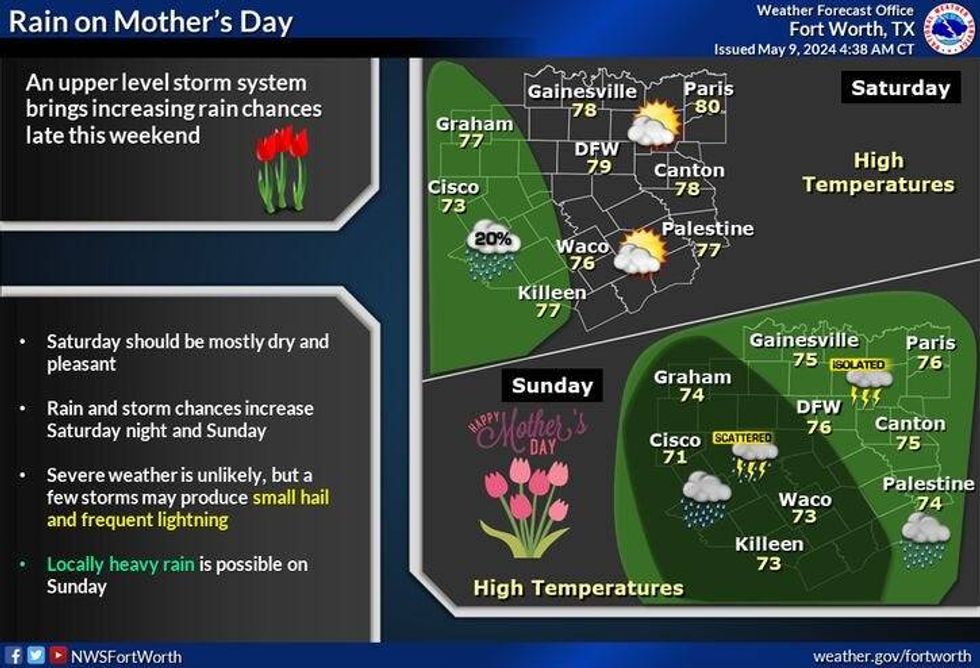
Clouds will increase the second half of Saturday but another nice day is ahead. Afternoon highs in the upper 70s. There will be some showers starting to move in from the west towards midnight into early Sunday morning.
Mother's Day looks wet, with off and on showers and non-severe storms. I will be monitoring a possible flooding threat as well. Highs in the 70s.
 NWS
NWS
Some leftover rain is possible before noon on Monday with slow clearing by afternoon. Afternoon highs will top out near 80°.
Tuesday looks quiet but much warmer. Mid to upper 80s... Near 90 on Wednesday with a ton of humidity both days.
We may have another strong storm system affecting our area late Wednesday into Thursday of next week. Stay tuned.
___________________________
7-Day Headlines:
* DFW Airport reached 95 yesterday.
* Severe storm threat this afternoon: Noon-6pm.
* Today's threat (Large hail, isolated tornadoes, wind): Tornado threat south of I-20.
* Cooler with lower humidity Friday and Saturday.
* Showers and non-severe storms for Mother's Day into Monday.
* Warm and humid on Tuesday.
_____________________________________________________
*Yest Rain: 0.00"; Yest High: 95R; Low: 75
*Today's Averages: High: 81; Low: 62
*Record high: 97 (1952) Record low: 46 (1923, 1969)
__________________________________________________________
*May Rain: 2.28"; Surplus: 1.08"
*2024 Rain: 19.55"; Surplus: 6.54"
*Sunrise: 6:33am; Sunset: 8:16pm
__________________________________________________________
Today: Scattered showers and severe storms today (Noon-6pm). Threats: Large hail (north of I-20); Damaging wind and isolated tornadoes (South of I-20). Stalled cold front. High: 80-85. WInd: ENE 10-20 mph.
Tonight: Partly cloudy and cooler. Low: 58-62. Wind: ENE 15-25 mph.
Tomorrow: Mostly sunny, breezy and pleasant. Lower humidity. High: Upper 70s. Wind: ENE 10-20 mph.
Saturday: Increasing clouds, continued pleasant. Showers towards midnight (West of DFW). High: Near 80.
Mother's Day: Cloudy and mild. Scattered showers and non-severe storms. High: Mid 70s.
Monday: Leftover showers and storms through noon, then partly cloudy. High: Near 80.
Tuesday: Partly cloudy and warmer. High: Mid to upper 80s.
Wednesday: Partly cloudy, warm and humid. Scattered storms return late. High: Upper 80s.
LISTEN on the Audacy App
Tell your Smart Speaker to "PLAY 1080 KRLD"
Sign Up to receive our KRLD Insider Newsletter for more news
Follow us on Facebook | Twitter | Instagram | YouTube