


Storm chances remain in our forecast for most of our new workweek and possibly into the weekend as well.
We're waking up to absolutely nothing on radar right now. That's nice! Temperatures range from the upper 60s to mid-70s across the area with a deck of clouds overhead.
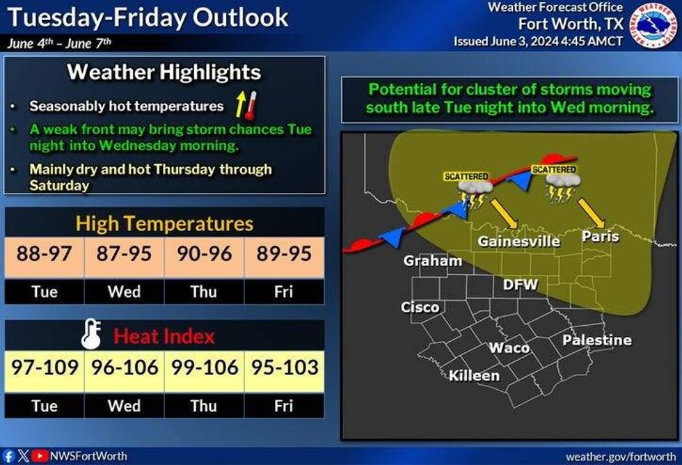
I'm currently tracking our next disturbance now in northwestern Oklahoma and southern Kansas, where a decent line of storms has formed over the past few hours. The movement of this complex is to the southeast. This puts parts of north Texas in line for more scattered showers and storms later on this afternoon into the evening hours. Areas west of 35W have less of a chance for storms than areas to the east. Threats: Hail up to quarters, damaging wind, and flash flooding. Afternoon highs will top out at a humid 88 today.
Another complex of storms will form in southwestern Kansas late this evening. I'll keep an eye on the track and strength of this complex overnight tonight. If it holds together, we will have more storms around the first half of tomorrow, Tuesday. Peeks of sunshine by afternoon with highs in the low 90s.
Rinse and repeat this forecast late Tuesday into noon Wednesday. We could see yet another complex of storms affect the area. This is not in stone. Please note, the type of weather pattern we are in right now is VERY hard to forecast for the strength and placement of storms ...more than 24 to 48 hours out. So stay tuned on Wednesday morning's rain chances.
 NWS
NWS
Afternoon highs will warm into the low to mid 90s Wednesday through the weekend. Heat index values will range between 100° and 108°.. I think most of Wednesday and Thursday are dry. and as of now, I'm not even going to think about our possible storm chances Friday through the Sunday. Some of the extended weather data IS showing a cold front stalling somewhere across North Texas or in southern Oklahoma. If the front stalls over us, more storms will be in the forecast. Stay tuned!
Please stay weather aware the next couple of days for isolated severe storms and more flooding in areas.
______________________________
7-Day Headlines:
* DFW Airport reached 88 yesterday. 0.63" of rain.
* Scattered afternoon and evening storms today. Isolated severe and flooding.
* Scattered early morning storms Tuesday and Wednesday.
* Heating up this week with a ton of humidity.
* Heat index values 100-105 starting Wednesday.
* No rain, as of now, Thursday - the weekend.
_____________________________________________________
*Yest Rain: 0.63"; Yest High: 88; Low: 686
*Today's Averages: High: 89; Low: 70
*Record high: 100 (1913) Record low: 52 (1919, 1946, 1970)
__________________________________________________________
*June Rain: 2.10"; Surplus: 1.83"
*2024 Rain: 27.17"; Surplus: 10.31"
*Sunrise: 6:20am; Sunset: 8:33pm
__________________________________________________________
Today: Mostly cloudy, warm and humid. Scattered afternoon and evening storms. A few may become severe. Threats: Hail, wind and flash flooding. High: Upper 80s. Wind: South 15-25 mph.
Tonight: A few leftover storms. Low: Low to mid 70s. Wind: South 15-25 mph.
Tomorrow: Scattered morning storms, some afternoon sun. Hot and humid. High: Low 90s. Wind: South 15-25 mph.
Wednesday: Scattered morning storms, some afternoon sun. Hot and humid. High: Low 90s.
Thursday - Sunday: Partly cloudy, hot and humid. Highs: Mid 90s...Heat index values: 100-108.
** Thursday - Sunday's forecast is subject to change. Scattered storms may be possible is a front stalls over the area**
LISTEN on the Audacy App
Tell your Smart Speaker to "PLAY 1080 KRLD"
Sign Up to receive our KRLD Insider Newsletter for more news
Follow us on Facebook | Twitter | Instagram | YouTube


