Temperatures are expected to remain below average for the next seven days, with no precipitation forecasted as of now. Plus another influx of Arctic air is anticipated by the end of the week.
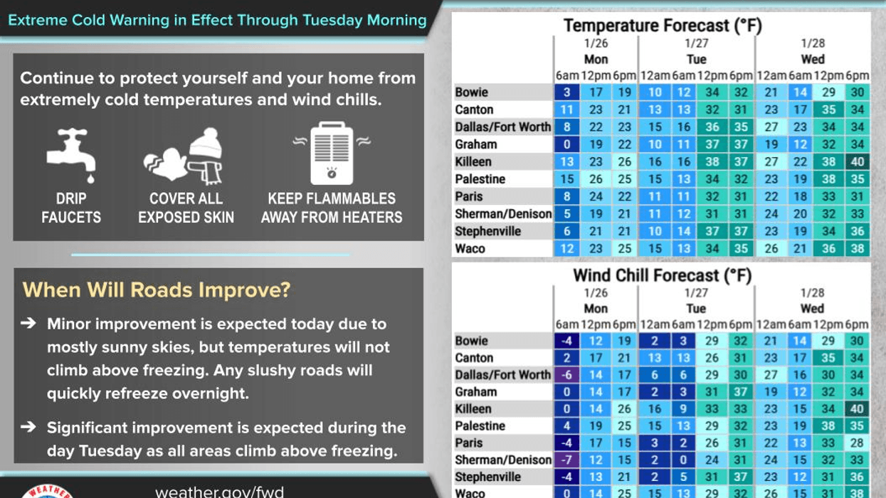
Good morning, everyone. I hope you have been staying warm. Temperatures have dropped to the upper single digits to low teens across North Texas this morning. The roads remain hazardous, but some improvement is expected throughout the day as sunshine returns. Afternoon highs will reach the upper 20s.
Due to the sunshine today and increased road activity, some improvement will occur. The combination of sunshine and road crews treating and plowing roads will make conditions slightly easier for some of you. Please note that interior and neighborhood roads will remain extremely treacherous.
There will be significant moisture on the roadways before sunset this evening, leading to flash freezing and black ice formation overnight. Temperatures will drop to the low teens on Tuesday morning.
Expect morning ice and afternoon sunshine on Tuesday, with temperatures potentially reaching 40 degrees. Another hard freeze is expected Wednesday morning, with readings in the low twenties. There will be areas of black ice, so please exercise caution.
Wednesday's forecast calls for sunny skies and a high of 42 degrees. Thursday will be the warmest day this week, with afternoon highs reaching the low 50s and increasing high clouds.
Another Arctic front will move into the area on Friday, bringing windy and much colder conditions by evening. Afternoon highs on Friday will struggle to reach 40 degrees, with wind chill values in the 20s by evening. Temperatures will drop to the teens on Saturday morning, with cloudy skies and a high of 35 degrees. Sunday's forecast calls for sunny skies, a low of 22 degrees in the morning, and a high of 42 degrees in the afternoon.
If you must venture out today or tomorrow, please exercise extreme caution and maintain a safe driving distance. Accelerate and brake slowly, and be particularly careful when exiting subdivisions, as ice will persist in these areas throughout the week.
Have a great day and stay warm!
7-Day Headlines:
* DFW Airport reached 21 yesterday
* Bone chilling cold this morning. Wind chills below zero.
* Extreme Cold Warning until noon today.
* We FINALLY get above freezing Tuesday.
* A brief warm up through Thursday.
* Another Arctic cold front Friday, no precipitation.
* A COLD weekend to come.
*Yest Rain: 0.00"; Yest High: 21; Low: 13
*Today's Averages: High: 58; Low: 37
*Record high: 82 (1953); Record low: 12 (1904)
*Yesterday rain: 0.93"; Snow: .9" Rec; Deficit:
*2026 Rain: 0.93"; Snow: 2.4" Deficit:
*Sunrise: 7:26am; Sunset: 5:56pm
Monday: Sunny and cold. Road clear up a bit. High: Upper 20s. Wind: North 5-10 mph.
Monday night: Clear and VERY cold. Black ice forms after sunset. Low: Low to mid teens. Wind: South 5-10 mph.
Tuesday: Sunny and a tad warmer. FINALLY above freezing! High: High: Upper 30s. Wind: South 5-10 mph.
Wednesday: Mostly sunny. Our warm up BRIEFLY continues. Low: Teens; High: Near 40.
Thursday: Mostly cloudy and chilly. Low: Low to mid 30s; High: Low 50s.
Friday: Mostly sunny, turning windy and colder during the day. Low: Near 30; High: Low 40s.
Saturday: Sunny, windy and cold. Low: Upper teens; High: Low to mid 30s.
Sunday: Increasing high clouds and chilly. Low: Mid 20s; High: Low to mid 40s.
LISTEN on the Audacy App
Tell your Smart Speaker to "PLAY 1080 KRLD"
Sign Up to receive our KRLD Insider Newsletter for more news
Follow us on Facebook | Twitter | Instagram | YouTube