


As promised, the cold front has arrived. Some of you lucky ones saw some brief heavy rain and thunder earlier this morning, north of DFW. More rain will form to our southwest later this morning and move across the area by late morning through the afternoon, however the bulk of the rain will fall south of Highway 380. The rain will end from west to east late this afternoon into the evening hours.
Temperatures have fallen into the low in mid-50s at this hour and will continue to steadily fall through the 40s today. Factor in the 30 mph wind gusts... wind chills will be in the 30s by late this afternoon. If you're heading to any high school playoffs this evening, make sure you layer up, it's going to be chilly.
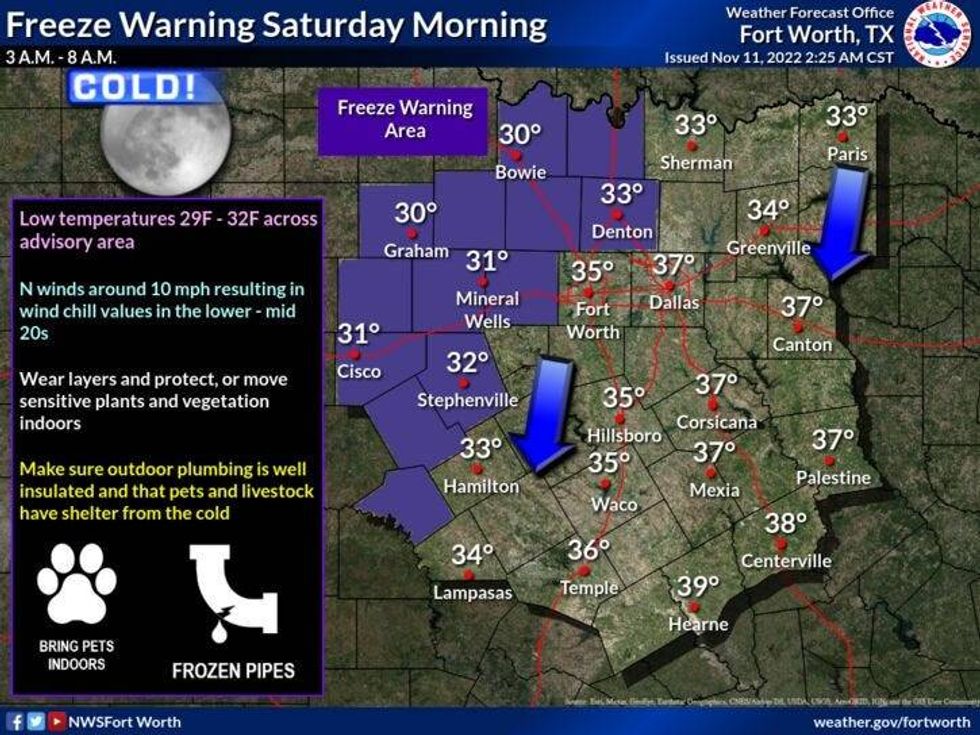
A freeze warning is in effect for Saturday morning. Skies will clear after midnight and temperatures will fall between 30 and 36 across North Texas. Make sure you protect your plants and pets.
 National Weather Service - Fort Worth
Plenty of sunshine, and cool temperatures will be felt this weekend. The high Saturday is 53°, Sunday 56°.
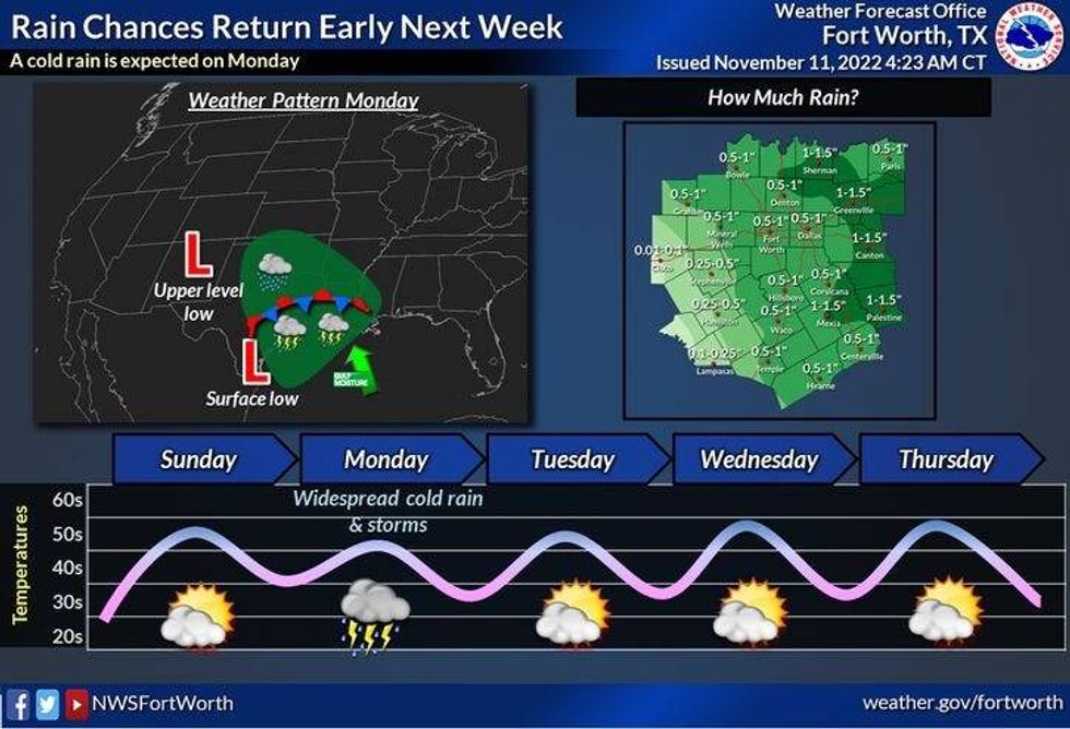
Another cold front will head to the area on Monday coupled with a very strong upper level disturbance. Widespread showers with isolated thunderstorms are expected across all of North Texas through late afternoon. Nothing severe is expected.Afternoon highs will hold steady in the mid 40s!
 National Weather Service - Fort Worth
Sunshine returns Tuesday through Thursday, but it will remain very chilly for this time of the year. The afternoon high on Tuesday will be near 50° low 50s for Wednesday and Thursday. Morning lows will be close to freezing in some areas.
More chilly rain may move into the area by late Thursday into Friday behind our next cold front. Also, plan on another chilly weekend next week.
*Yest Rain: Trace; High: 75; Low: 62
*Today's Averages: High: 68; Low: 48
*Record high: 85 (1911); Record low: 19 (1950)
*November rain: 3.04"; Surplus: 2.02"
*2022 Rain: 30.89"; 2022 deficit: 1.77"
*Sunrise: 6:55am; Sunset: 5:29pm
Friday - Veterans Day: Cloudy, windy and MUCH colder. Scattered showers through the afternoon: High: Falling temperatures through the 40s. Wind chills in the 30s by evening. Wind: North 15-25, G30 mph.
Tonight: *Freeze Warning Saturday morning north and west of DFW.* Decreasing clouds, windy and cold. Low: Low to mid 30s. Wind chills in the 20s. Protect plants and pets. Wind: North 15-25, G30 mph.
Saturday Sunny, breezy and chilly. High: Low 50s.
Sunday: Mostly sunny, continued cool. Low: Mid to upper 30s. High: Mid 50s.
Monday: Cloudy, breezy and chilly. Showers and a few rumbles a good bet. High: Steady in the 40s.
Tuesday: Partly cloudy, windy and chilly. High: Near 50.
Wednesday: Partly cloudy, continued chilly. High: Low 50s.
Thursday: Increasing clouds and cool. Chance of rain late. High: Low 50s.

LISTEN on the Audacy App
Tell your Smart Speaker to "PLAY 1080 KRLD"
Sign Up and Follow NewsRadio 1080 KRLD


