


Cold front No. 1 moved through North Texas overnight, cold front No. 2 will arrive Saturday night, and cold front No. 3 will arrive on Tuesday. It's a 1-2-3 punch and there is a threat of some light snow late Monday into Tuesday.
The first cold front moved through the area shortly after midnight Saturday. Wind shifted to the north and is gusting up to 30 mph, which will continue throughout the day. Temperatures have fallen to near 40 degrees with wind chills near 30 degrees. Expect minimal warming Saturday, despite plenty of sunshine. Temperatures will remain steady in the low to mid-40s throughout the day, with wind chills in the 30s.
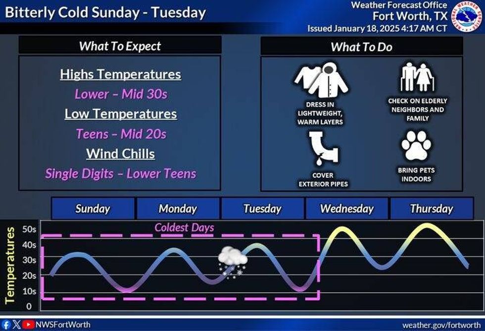
A Cold Weather Advisory will go into effect at midnight and will remain in place until 9 a.m. Sunday. The advisory was previously referred to as a wind chill advisory but has undergone a name change. Morning lows will dip into the upper teens to low 20s, but wind chills will be down near 10 degrees in some areas.
After morning clouds clear out on Sunday, expect plenty of sunshine throughout the day. Afternoon highs will reach the mid-30s, with wind chills in the 20s throughout the day.
It will start off sunny on Monday morning, with low temperatures in the upper teens to low 20s. Clouds will increase throughout the day, and we'll begin to see some light snow moving in from the southwest by late afternoon Monday. A significant amount of this snow will evaporate before reaching the ground, especially along and north of Interstate 20. Afternoon highs will struggle to get above freezing.
Overnight Monday into Tuesday, skies will remain cloudy with light snow flying in North Texas. Current data suggests accumulations of less than 1 inch along and north of Interstate 20. Accumulations greater than one inch are possible south of Interstate 20, with increasing snow totals the farther south you get away from DFW. Afternoon highs will range between 28 and 32 degrees.
If I were to draw a line for accumulations greater than an inch right now, it would be along and south of a Tyler to Palestine to Waco to Lampasas line. This area may see two to three inches of snow. The latest data also indicates a wintry mix as far south as San Antonio and Houston during the day on Tuesday. That's where the freeze line will settle on Tuesday afternoon.
What's different about this storm system compared to the one last week is that this system is traveling farther south of North Texas, the air will be significantly drier, and a third push of dry air arrives here during the first half of Tuesday, suppressing high snow totals to the south of us.
By Wednesday, the sun will be back out, and we'll creep up to near 40 degrees. It will be sunny near 50 for Thursday, and then we'll get cold again on Friday into the following weekend.
 National Weather Service
7-Day Headlines
* DFW Airport reached 63 on Friday.
* Arctic cold front has arrived.
* Cold Weather Advisory overnight tonight. WInd chills in the teens!
* Protect pipes, plants, pets and people.
* Staying VERY cold through Wednesday.
* Watching for light snow accumulations late Monday into Tuesday, heavier south of I-20.
* Warming a bit Wednesday and Thursday.
_____________________________________________________
*Yest Rain: Trace; Yest High: 63; Low: 42
*Today's Averages: High: 57; Low: 36
*Record high: 80 (1914, 1923); Record low: -1 (1930)
________________________________________________________
*January Rain: 1.56"; Surplus: 0.12"
*2025 Rain: 1.56; Snow: 2.30"; Surplus: 0.12"
*Sunrise: 7:30am; Sunset: 5:49pm
________________________________________________________
Today: Mostly sunny, windy and colder. High: Low to mid 40s. Wind: North 15-25, G30.
Tonight: **Cold Weather Advisory** Increasing clouds, windy and cold. Low: Low to mid 20s. Wind chills in the low teens. Pipes, pets, people and plants. Wind: NNW 15-25 mph.
Tomorrow: Morning clouds/flurries NW of DFW, becoming sunny by late morning. Windy and cold y'all!! High: Low to mid 30s. Wind chills in the 20s. Wind: NW 15-25 mph.
Monday: Increasing clouds, windy and cold. Chance of light snow by evening. Heavier south of Interstate 20. Lows: Low to mid 20s. Wind chills in the teens again. High: Low to mid 30s.
Tuesday: Cloudy and cold. Chance of light snow in DFW with minor accumulations. Heavier-accumulating snow south of a Tyler to Waco to Lampasas line. High: 28-32.
Wednesday: Mostly sunny, breezy and a bit warmer. High: Near 40.
Thursday: Partly cloudy and cool. High: Upper 40s.
Friday: Mostly cloudym windy and colder. High: Low 40s.
 National Weather Service
LISTEN on the Audacy App
Tell your Smart Speaker to "PLAY 1080 KRLD"
Sign Up to receive our KRLD Insider Newsletter for more news
Follow us on Facebook | Twitter | Instagram | YouTube


