


North Texas has enjoyed a beautiful week with mild temperatures -- and just think, at this time 3 years ago, we dropped below zero! This morning, the temperature was 60 degrees at 5:45 a.m.
Another beautiful day is ahead Friday with plenty of cloud cover and afternoon highs will touch 70 degrees. But, just a subtle reminder, grab a heavy coat on your way out the door this morning, because you'll need it on the way home from work today. A strong cold front will blast through North Texas by mid to late afternoon and drop temperatures into the mid-40s by 9 p.m. Wind chills will be in the 30s due to the north wind gusting to 30 mph.
Temperatures will continue to tumble overnight with Saturday morning lows ranging between 30-35 degrees. Wind chills will be well down into the 20s. Protect your tender vegetation and bring your pets and doors.
Sunny, windy, and chilly for Saturday, with afternoon highs in the mid to upper 40s. Wind chills will be in the 30s most of the day. Protect your plants and bring your pets indoors Saturday night, because there will be a freeze across much of the area by Sunday morning. Morning lows will dip to 28-32 degrees, but the wind will have relaxed by then.
Sunday will be a chilly day with less wind. Afternoon highs will reach the mid to upper 50s.
Plenty of sunshine is in the forecast Monday through Thursday. Highs on Monday will reach the low 70s, upper 70s on Tuesday, low 80s on Wednesday, and then slightly cooler behind a weak cold front on Thursday with highs in the mid-70s.
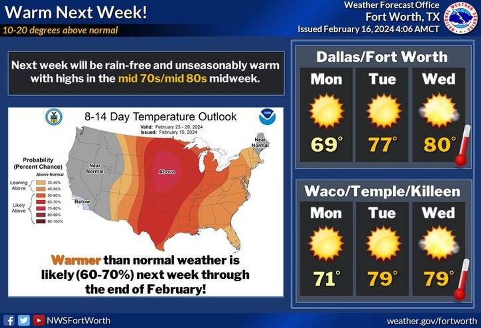 Warmer temperatures arrive MondayNational Weather Service
7-Day Headlines:
* DFW Airport reached 70 degrees on Thursday.
* A mild day, turning sharply colder later Friday.
* Near freezing temperatures Saturday morning. Chills in the 20s.
* A chilly and windy Saturday. A cool Sunday.
* A light freeze Sunday morning. Protect plants and pets.
* A quick warm up next week. Widespread 70s and 80s by Wednesday.
_____________________________________________________
*Thursday Rain: 0.00"; Thursday High: 70 Low: 49
*Friday's averages: High: 61; Low: 40
*Record high: 85 (2005); Record low: -2 (2021)
_______________________________________________________
*February Rain: 1.88"; Surplus: 0.53"
*2024 Rain: 5.08"; Surplus: 1.20"
*Sunrise: 7:11am; Sunset: 6:14pm
________________________________________________________
Friday: Mostly cloudy and mild through the afternoon. Cold front arrives by dinner time. Readings on the 40s by this evening. Chills in the 30s! High: Near 70. Wind: Shifting NNW 15-25, G30 mph.
Friday night: Partly cloudy, windy and colder. Low: 30-35. Chills in the 20s. Wind: NNW 15025, G30 mph.
Saturday: Sunny, windy and cold. High: Mid to upper 40s. Wind: NNW 15-25, G30 mph.
Sunday: Light morning freeze, then sunny and cool. High: Mid to upper 50s.
Monday: Sunny and warmer. High: Low 70s.
Tuesday: Sunny and warm. High: Upper 70s.
Wednesday: Mostly sunny, windy and continued warm. High: Low 80s.
Thursday: Mostly sunny, breezy and mild. Weak cold front. High: Low to mid 70s.
LISTEN on the Audacy App
Tell your Smart Speaker to "PLAY 1080 KRLD"
Sign Up to receive our KRLD Insider Newsletter for more news
Follow us on Facebook | Twitter | Instagram | YouTube


