


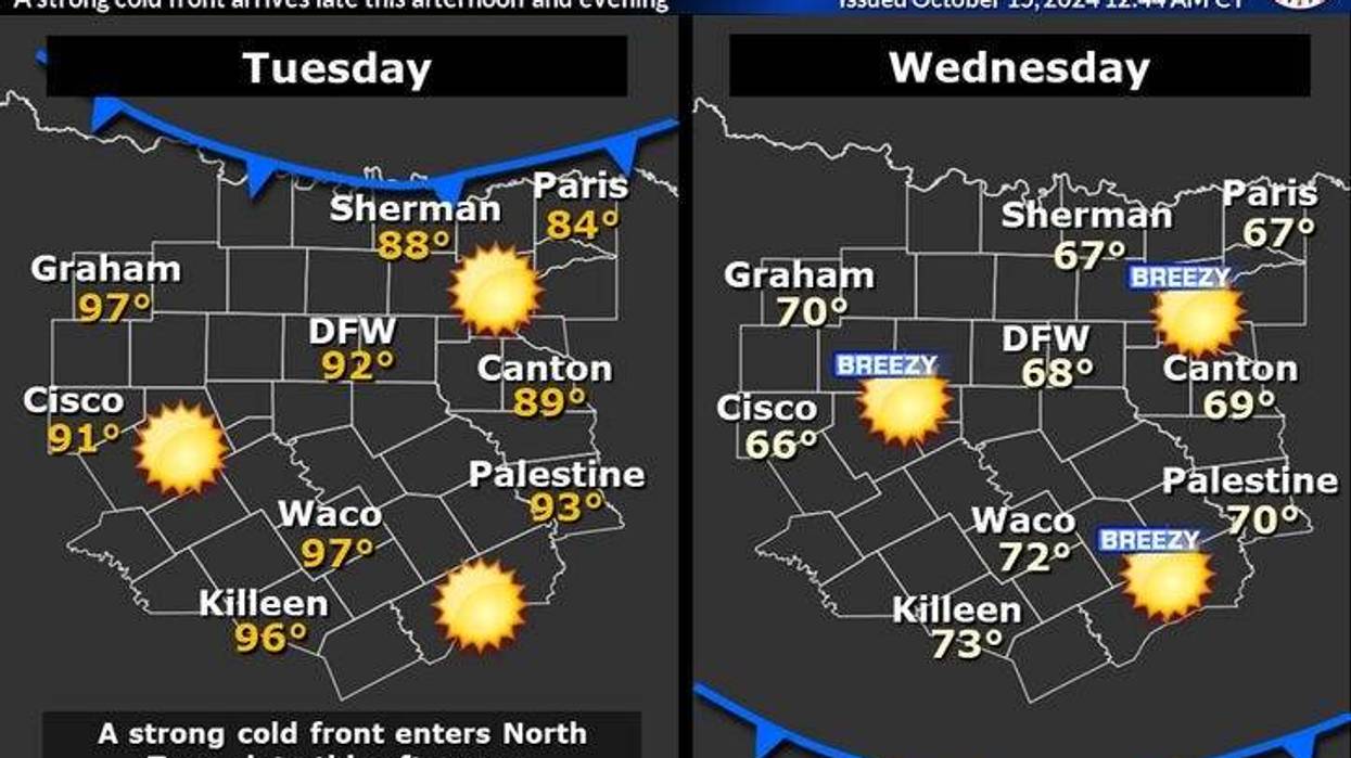
A cold front will make its way to North Texas by Tuesday night, but first, we have to endure high temperatures in the low 90s.
Tuesday morning temperatures fell into the 50s to low 60s across North Texas with a light wind. It will be sunny and quite warm with afternoon highs reaching the low 90s with plenty of sunshine.
By this evening, a strong cold front will plow through the area. The wind will shift to the north and gust to 35 mph through early Wednesday morning. Temperatures will be between 50 and 55 degrees, with a north wind still gusting to 30 mph. This will put the feels-like temperature in the 40s.
Plenty of sunshine Wednesday with breezy conditions. Afternoon highs will only reach the upper 60s. The average high is 79 degrees.
Believe it or not, some areas may want to protect their tender vegetation on Thursday morning. Some of the outlying areas may drop into the upper 30s. The upper 40s will reside in areas closest to town. The average low this time of the year is 57 degrees. Wednesday is a perfect day to head to the State Fair of Texas.
Temperatures will slowly warm into Friday. After a cool start Thursday, with lows in the 50s, afternoon highs will reach the upper 70s with a south wind increasing to 10-20 mph.
Friday into the weekend will be fantastic under a partly cloudy sky. Afternoon highs will touch the 80-degree mark, with morning lows in the mid-50s to low 60s. No rain is in the forecast.
More of the same for Monday. Skies will be partly cloudy with afternoon highs in the low 80s.
 Texas drought monitorNational Weather Service
7-Day Headlines
* DFW Airport reached 82 on Monday.
* Very warm Tuesday. Low 90s!
* Strong cold front Tuesday evening. Windy and chilly Wednesday morning.
* Below average temperatures through Friday.
* Widespread 40s for lows Thursday morning.
* Grass fire danger.
* Warming a bit this weekend, but still very nice!
_____________________________________________________
*Monday Rain: 0.00"; Monday High: 82; Low: 66
*Tuesday's Averages: High: 79; Low: 57
*Record high: 95 (2015); Record low: 40 (2018)
________________________________________________________
*October Rain: 0.00"; Deficit:
*2024 Rain: 33.94"; Surplus: 4.98"
*Sunrise: 7:33am; Sunset: 6:54pm
________________________________________________________
Tuesday: Sunny and warm. High: Low 90s. Wind: SE 10-15 mph.
Tuesday night: Clear, windy and much cooler. Evening cold front. No rain with it. Low: 50-55 Wind: NNE 15-25, G30 mph.
Wednesday: Ample sunshine, breezy, and much cooler. High: Upper 60s. Wind: ENE 10-20 mph.
Thursday: Sunny and pleasant. Lows: 38-48; High: Low 70s.
Friday: Sunny, breezy and lovely. High: Upper 70s.
Weekend: The last weekend of the State Fair. Sunny, breezy, and seasonable. Highs: Near 80.
Monday: More of the same. Partly cloudy and a tad warmer. High: Low 80s.
LISTEN on the Audacy App
Tell your Smart Speaker to "PLAY 1080 KRLD"
Sign Up to receive our KRLD Insider Newsletter for more news
Follow us on Facebook | Twitter | Instagram | YouTube


