Say goodbye to the 80s, hopefully for the rest of the year, and hello to cooler weather. A cold front is moving through north Texas this morning.
Widespread rain will start to move in from the SW by late morning and continue through Friday morning. The cool weather will also stick around through the weekend and into the middle of next week. Those are your weather stories over the next 7 days.
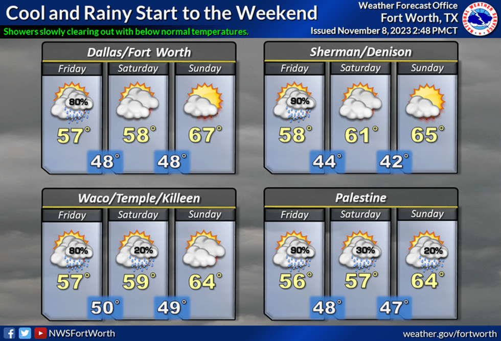
We're starting Thursday with temperatures in the 60s this morning, but temperatures will be falling through the 50s through the day. There's nothing showing up on radar right now, but the widespread rain currently to our SW, will move into the area by late morning and continue off and on through Friday morning. Average rainfall totals in DFW will be close to an inch, with lighter totals north and west, and heavier totals south and east. Nothing severe is expected.
A few leftover showers are in the forecast on Friday, with morning lows in the upper 40s, afternoon highs will struggle to get above 55°.
 National Weather Service - Fort Worth
Out SW flow aloft will continue into the weekend spreading more clouds across the area on Veterans day. This will keep the temperatures on the cool side with highs near 60°. No rain is in the forecast.
A weak cold front will move into the area by Sunday evening. Afternoon highs will warm into the mid to upper 60s.
A system in deep south Texas will spread more clouds into the area on Monday, with afternoon highs in the mid-60s. As of now, the measurable rain should stay south of DFW late Monday into Tuesday, but I can't rule out some showers sneaking into parts of the area.
Tuesday will be mostly cloudy with highs in the mid-60s again, and more sunshine by Wednesday with temps in the upper-60s.
If you need to run some errands this morning, I would do it before 11:00 a.m., because widespread rain will be moving into north Texas towards lunchtime.
*Yest Rain: 0.00"; Yest High: 86; Low: 68
*Today's Averages: High: 69; Low: 48
*Record high: 88 (2005); Record low: 28 (1955, 1991)
*November rain: 0.00"; Deficit: 0.85"
*2023 Rain: 25.29"; Deficit: 7.20"
*Sunrise: 6:54am; Sunset: 5:30pm
Today: Morning cold front, then waves of rain through the day (0.50"). Windy and much cooler. High: Falling temps into the 50s. Wind: North 10-20, G25 mph.
Tonight: Cloudy, breezy and cool. Scattered showers possible (0.25"-0.50"), heaviest south and east of DFW. Low: Low 60s. Wind: North 15-25 mph.
Friday: Cloudy, breezy and cool. A few leftover showers (0.10") High: Mid-50s. Wind: NNE 10-20 mph.
Weekend: Mostly to partly cloudy and pleasant. High: 60 (Sat.); 68 (Sun.)
Monday: Mostly cloudy and nice. High: Mid 60s.
Tuesday and Wednesday: Partly cloudy and seasonable. Slight chance of showers on Tuesday. Highs: MId to upper 60s.
LISTEN on the Audacy App
Tell your Smart Speaker to "PLAY 1080 KRLD"
Sign Up to receive our KRLD Insider Newsletter for more news
Follow us on Facebook | Twitter | Instagram | YouTube