Temperatures fell to near 20 degrees on Sunday morning with wind chills in the single digits. As a result, the Cold Weather Advisory will remain in effect until 9 a.m. Monday. This advisory was previously referred to as a Wind Chill Advisory. Several more hard freezes are expected through Wednesday, but the wind will subside.
The coldest air of the winter season is in place across North Texas, and it will remain until the end of the week.
Sunday started with temperatures near 20 degrees and wind chills in the single digits. Although the sun is out, it will only warm to the low to mid-30s on Sunday, with wind chills remaining in the teens and 20s throughout the afternoon.
The wind will subside Sunday night, but under clear skies, temperatures will plummet to between 15 and 22 degrees across North Texas. Wind chills will not be a factor.
Temperatures will remain cold on Monday, with afternoon highs in the low to mid-30s. Clouds will rapidly increase during the second half of the day, through the evening and overnight into Tuesday morning. By Monday evening, an area of light snow will be moving in from the north and south. The snow from the north will dissipate before reaching North Texas on Tuesday morning.
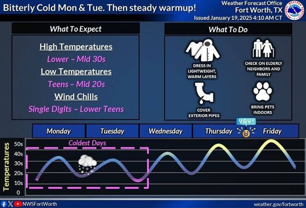 Cold temperatures this week.National Weather Service
However, the snow moving in from the south requires some attention. This storm will be distinct from last week's storm, as very dry air will be in place across North Texas, and precipitation will attempt to move in from the south towards midnight Monday into early Tuesday morning. Much of this precipitation will evaporate before reaching the ground. Nevertheless, areas along and south of Highway 380 may experience a dusting of snow on the ground through noon on Tuesday.
Another surge of dry air will enter the area on Tuesday, and the surface low forming in the Gulf of Mexico will be farther south than the one last week. This combination will limit accumulations across Dallas, Fort Worth, and points north. Residents south of the Lufkin-to-Killeen-to-Austin-to-Fredericksburg line can expect accumulating snow, with occasional sleet mixing in on Tuesday. Winter Storm Watches are in effect in these areas through Tuesday evening.
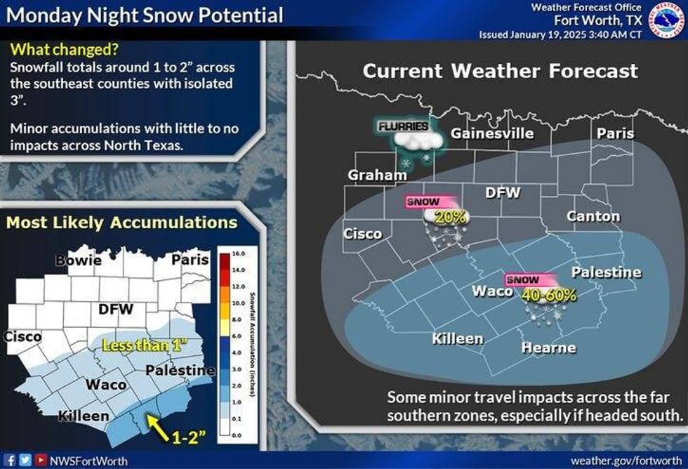 Monday night snow possible in North Texas.National Weather Service
Starting Monday night, these watches will likely become Winter Storm Warnings. Areas north of this line and south of the Tyler-to-Palestine-to-Hillsboro-to-Hamilton line may have Winter Weather Advisories issued.
I am not overly concerned about hazardous travel conditions across areas north of Interstate 20 with this next event, as the snow will be very light and powdery. Temperatures on Tuesday will range from 28 to 32 degrees, with the coldest temperatures in the snowy areas approximately 60-100 miles south of DFW.
Following another freeze on Wednesday morning, temperatures will rebound, and a south wind will return. Highs will reach the mid to upper 40s. The warming trend will continue through the end of the week and into the first part of the weekend, when our next weather change will arrive.
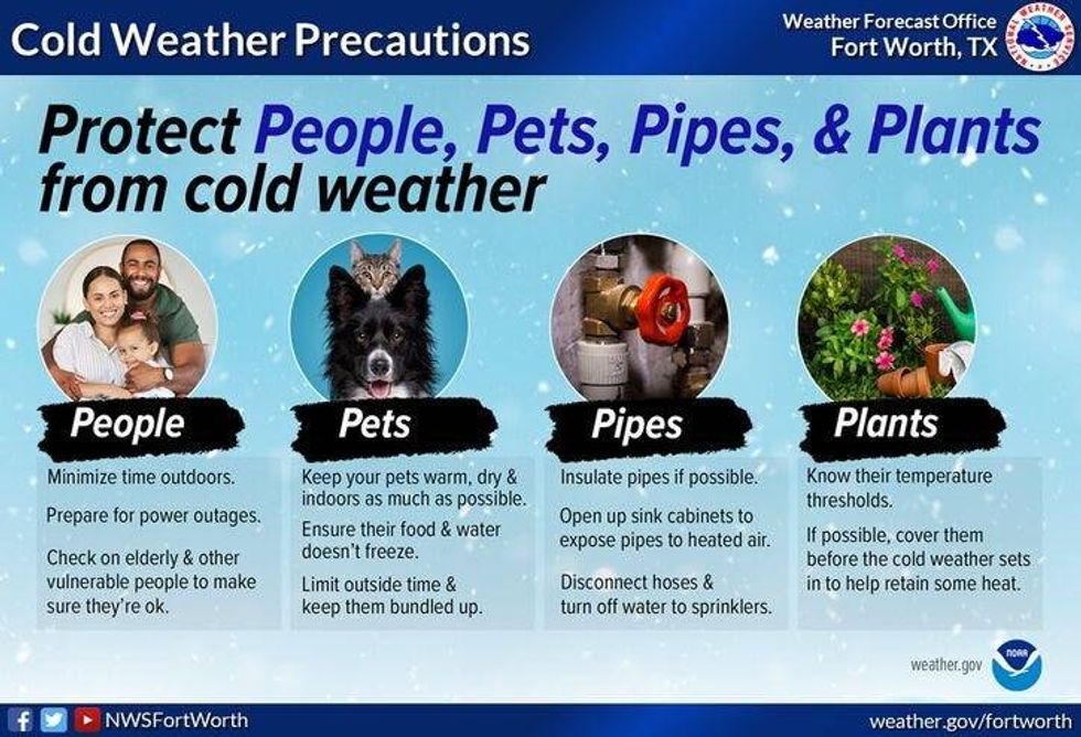 Protect people, pets, pipes, and plants.National Weather Service
7-Day Headlines
* DFW Airport reached 57 on Saturday, shortly after midnight.
* Arctic cold front No. 2 arrived early Sunday.
* A Cold Weather Advisory is in place through 9 a.m. Monday for dangerous wind chills. Single digits and teens.
* Protect pipes, plants, pets, and people.
* Staying very cold through Wednesday.
* Watching for light snow accumulations late Monday into noon Tuesday, heavier well south of I-20.
* Warming a bit on Wednesday and Thursday.
_____________________________________________________
*Saturday Rain: 0.00"; Saturday High: 57; Low: 28
*Sunday's Averages: High: 57; Low: 36
*Record high: 84 (1952); Record low: 5 (1943)
________________________________________________________
*January Rain: 1.56"; Surplus: 0.03"
*2025 Rain: 1.56; Snow: 2.30"; Surplus: 0.03"
*Sunrise: 7:29am; Sunset: 5:50pm
________________________________________________________
Sunday: **Cold Weather Advisory** Mostly sunny, windy, and cold. High: Low to mid-30s. Wind chills teens to low 20s. Wind: North 15-25 mph.
Sunday night: **Cold Weather Advisory** Clear and pipe-bursting cold. Low: 17-22. Pipes, pets, people, and plants. Wind: NE 5-10 mph.
Monday: Increasing clouds and cold. High: Low to mid-30s. Wind: East 5-10 mph.
Monday night: Cloudy and cold. Chance of light snow after dinner towards midnight. A dusting is possible across DFW and points north. Low: 20-23.
Tuesday: Cloudy and cold. Chance of light snow through noon in DFW. Dusting DFW -> north, less than 1" of I-20. Accumulating snow (1"-2") south of a Tyler to Waco to Lampasas line. Greater accumulations (2"-4") in the Winter Storm Watch areas south of a Lufkin to College Station to Austin to Fredericksburg line. High: 28-32.
Wednesday: High clouds, breezy, and a bit warmer. High: Mid to upper 40s, colder in snowy areas.
Thursday: Mostly sunny and cool. High: Low to mid-50s.
Friday: Mostly sunny, windy, and seasonable. High: Mid to upper 50s.
Saturday: Increasing clouds. Chance of showers. High: Low 60s.
LISTEN on the Audacy App
Tell your Smart Speaker to "PLAY 1080 KRLD"
Sign Up to receive our KRLD Insider Newsletter for more news
Follow us on Facebook | Twitter | Instagram | YouTube