


After a spectacular sunset yesterday evening, the air has dried out and temperatures have fallen into the 40s across North Texas. Strong to isolated severe storms are possible later today south and east of DFW, followed by a strong cold front arriving pre-midnight.
Good morning, ladies and gentlemen. We have almost made it through our first full week of 2026. Congratulations are in order. I am curious to know if you have written 2025 yet or if you are aware of the current day. It is, in fact, Friday.
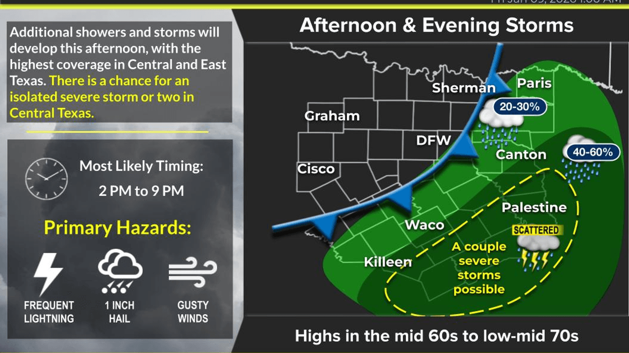
A light jacket will be necessary this morning as temperatures have fallen into the 40s across North Texas, with no significant wind to speak of. However, I anticipate wind chills to be a concern by tomorrow morning as a strong cold front is expected to move through the area around midnight. Residents northwest of DFW can expect more sunshine than areas southeast today. An upper-level disturbance currently moving through the Texas Panhandle will produce snowfall north of Interstate 40, with three to four inches possible in Dalhart, where winter storm warnings are in effect. This disturbance will also produce scattered strong to isolated severe storms about 80 to 100 miles south and east of Dallas in Fort Worth this afternoon into the evening hours, with hail and wind being the primary threats. I do not anticipate any precipitation in DFW. Afternoon highs today will reach the low 70s ahead of the strong front.
Temperatures will range from 35 to 40 degrees Saturday morning, with wind gusts of 25 to 30 mph resulting in wind chills in the upper 20s. It is essential to bring pets indoors and cover tender vegetation before bedtime tonight. While I do not expect a freeze tomorrow morning, I anticipate one on Sunday morning. At least the winds will have subsided by then. Saturday will be sunny, windy, and cool, with afternoon highs ranging from 48 to 53 degrees from south to north.
Sunday morning will be clear and chilly, with temperatures ranging from 27 to 33 degrees, coming close to freezing officially at DFW airport. Sunday will be sunny, less windy, and cool, with highs in the mid to upper 50s, which is average for this time of year.
The period from Monday to Thursday of next week will be uneventful, with chilly mornings and cool afternoons. Temperatures will reach the low 60s on Monday, upper 60s on Tuesday, and then drop back into the low 60s on Wednesday and Thursday due to a weak Wednesday DRY cold front. Morning lows will be in the 30s by the middle of next week, but I do not anticipate a freeze at this time.
Although I do not see any bitter cold air in the near future, there may be a pattern change by the end of next week into the following week as our subtropical jet stream becomes more active, leading to increasing precipitation chances. Stay tuned.
Have a terrific day today, a splendid weekend, and remember to always appreciate the weather when you can, as it is the only weather we have.
7-Day Headlines:
* DFW Airport reached 80 yesterday.
* Scattered strong storms SE and East of DFW.
* STRONG cold front pre midnight.
* A windy and colder Saturday. Wind chills in the 40s all day.
* Freezing temperatures Sunday morning.
* A dry and cool start to next week, no rain.
*Yest Rain: 0.01"; Yest High: 80; Low: 59
*Today's Averages: High: 56; Low: 36
*Record high: 82 (1957); Record low: 12 (1962, 1977)
*January Rain: 0.01"; Deficit:
*2026 Rain: 0.00"; Deficit:
*Sunrise: 7:32am; Sunset: 5:40pm
Friday: Mostly to partly cloudy and comfortable. Scattered strong to severe storms this afternoon and evening South and east of DFW. High: Low 70s. Wind: North 5-10 mph.
Friday night: Partly cloudy, windy and MUCH colder. Pre midnight cold front. Low: 35-40. Wind chills in the 20s. Wind: NNW 15-25, G30 mph.
Saturday: Mostly cloudy SE, mostly sunny NW. Breezy and chilly. High: 48-53. Wind chills in the 40s. Wind NW 15-25 mph.
Sunday: Morning freeze, afternoon sun. Seasonable temperatures. Less wind. Low: 27-33; High: Mid to upper 50s.
Monday: Light morning freeze away from DFW. Partly cloudy and beautiful. Golf anyone? High: Mid 60s.
Tuesday: Mostly sunny and pleasant. High: Near 70.
Wednesday: High clouds and cool. Weak rain-free cold front. High: Low 60s.
Thursday: Sunny and cool. High: Near 60.
LISTEN on the Audacy App
Tell your Smart Speaker to "PLAY 1080 KRLD"
Sign Up to receive our KRLD Insider Newsletter for more news
Follow us on Facebook | Twitter | Instagram | YouTube


