Outdoor activities are becoming increasingly popular as the weekend approaches and the weather is expected to be spectacular, with a rapid warm-up commencing after today. Temperatures are anticipated to rise significantly, reaching the mid-80s by Sunday.
Good morning, and welcome to almost Friday. I am taking tomorrow off, so this will be my last forecast discussion until next Monday. I believe I deserve a day off.
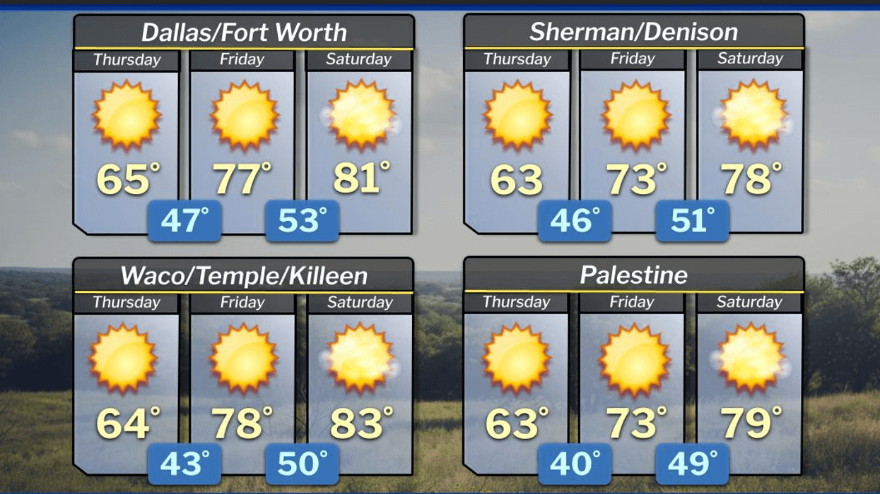
To start the day, grab a jacket as temperatures have fallen into the upper 30s to mid-40s across North Texas, accompanied by a light wind. Although the day ahead is expected to be beautiful, it will be slightly cool for this time of year. Afternoon highs will only reach the mid-60s, with a light variable wind.
South winds will return tomorrow, bringing warmer weather. Plenty of sunshine is expected, with afternoon highs in the mid-to-upper 70s. Our weather will continue to improve over the weekend, with south winds picking up to 25 mph. Plenty of sunshine will dominate Saturday, with highs in the low 80s. If you're attending the Greenville St. Patty's Day parade, morning lows will be in the low to mid-50s.
Temperatures will rise even higher on Sunday. If you're heading to the Java House Arlington Grand Prix, temperatures will start near 60°F and warm up to the mid-80s. However, be prepared for a strong cold front to move through the area during the afternoon, bringing north winds gusting up to 35-40 mph and temperatures falling through the 50s around dinner time.
Readings will continue to drop to the low to mid-30s on Monday morning, accompanied by a stiff north breeze. Wind chills will be in the 20s. As I mentioned a couple of weeks ago, we're not done with freezes yet, and this upcoming cold front will bring another round of chilly temperatures. Monday will be a very chilly day, with temperatures potentially not rising above 50°F and north winds still gusting up to 20 mph.
Another light freeze is possible, especially east and northeast of the Dallas-Fort Worth area, on Tuesday morning, with afternoon highs returning to the 60s. We can expect temperatures to warm into the 70s by Wednesday of next week.
As you've read above, no rain is in the forecast for the next 7 days, and I don't anticipate any rain through the end of next week. Enjoy the weather while it lasts. Have a terrific day today, an awesome weekend, and enjoy the weather when you can, it's the only weather you've got.
7-Day Headlines:
* DFW Airport reached 78 yesterday.
* A seasonable day today.
* Warming up through the weekend.
* PERFECT weather for outdoor activities.
* STRONG cold front Sunday afternoon.
* Near FREEZING Monday and Tuesday mornings
* A chilly and windy Monday.
* Warming up next Tuesday through week's end.
*Yest Rain: 0.51"; Yest High: 78; Low: 51
*Today's Averages: High: 67; Low: 47
*Record high: 91 (1918); Record low 14 (1948)
*March rain: 2.91"; Surplus: 1.69"
*2026 Rain: 5.15"; Snow: 2.4" Deficit:
*Sunrise: 7:41am; Sunset: 7:35pm
Thursday: Sunny and cool. Less wind by afternoon. High: Mid 60s. Wind Lt. Var.
Thursday night: Clear and cool. Low: Low 50s. Wind: South 5-10 mph.
Friday: Sunny, breezy, continued nice. High: Upper 70s. Wind: South 10-20 mph.
Saturday: Greenville Ave. St. Patrick's Day Parade. Sunny, windy and beautiful. High: Low 80s.
Sunday: Partly cloudy, turning windy and colder by afternoon. High: Low to mid 80s.
Monday: Sunny, windy and chilly. Low: 28-33; High: Near 50.
Tuesday: Sunny, less wind and pleasant. Low: 28-35; High: Low 60s.
Wednesday: Sunny and a bit warmer. High: Low 70s.
LISTEN on the Audacy App
Tell your Smart Speaker to "PLAY 1080 KRLD"
Sign Up to receive our KRLD Insider Newsletter for more news
Follow us on Facebook | Twitter | Instagram | YouTube