


The weather change in North Texas arrives after midnight with showers and storms. More rain is in the forecast through Monday. Much cooler weather arrives by Tuesday and Wednesday of next week.
Wednesday began with a cloudy sky, wind, and mild, muggy conditions. There could be some showers around the area through the afternoon. Some may be enough to wet the roadways and cause slick conditions. Precipitation totals will be light. Peeks of sunshine will appear Wednesday afternoon and highs will warm into the mid-80s. A south wind will gust to 35 mph.
A cold front will move through the area overnight and produce a thin line of showers and storms. The severity looks low, but one or two could become severe with gusty wind and or hail. The tornado threat is not zero, but it's low. The worst of this system will be in the South Plains and northern Oklahoma.
There will be rapid clearing on Thursday, breezy and cooler with afternoon highs and the low to mid-70s. Trick-or-Treaters will enjoy a clear sky with temperatures falling through the 60s.
The cold front will lift back to the north by Friday night and produce some scattered showers and storms with it. Increasing clouds Friday with highs in the mid to upper 70s.
A slow-moving upper-level disturbance will dig into the desert southwest this weekend. Spokes of energy, combined with deep surface moisture and warming afternoon temperatures will produce scattered showers and storms on Saturday. A few may be strong or severe. The next round of storms will hold off until late Sunday. A few of these storms may be strong to severe. Afternoon highs this weekend will warm into the mid to upper 70s.
Data is slowly coming together to kick the system out of the state from west to east on Monday. A dry line will move through. It will turn windy and dryer with afternoon highs still in the 70s. The cooler air won't move in until Tuesday. Clearing skies, windy conditions, and low humidity move into the area. Some areas may not get out of the 60s for highs.
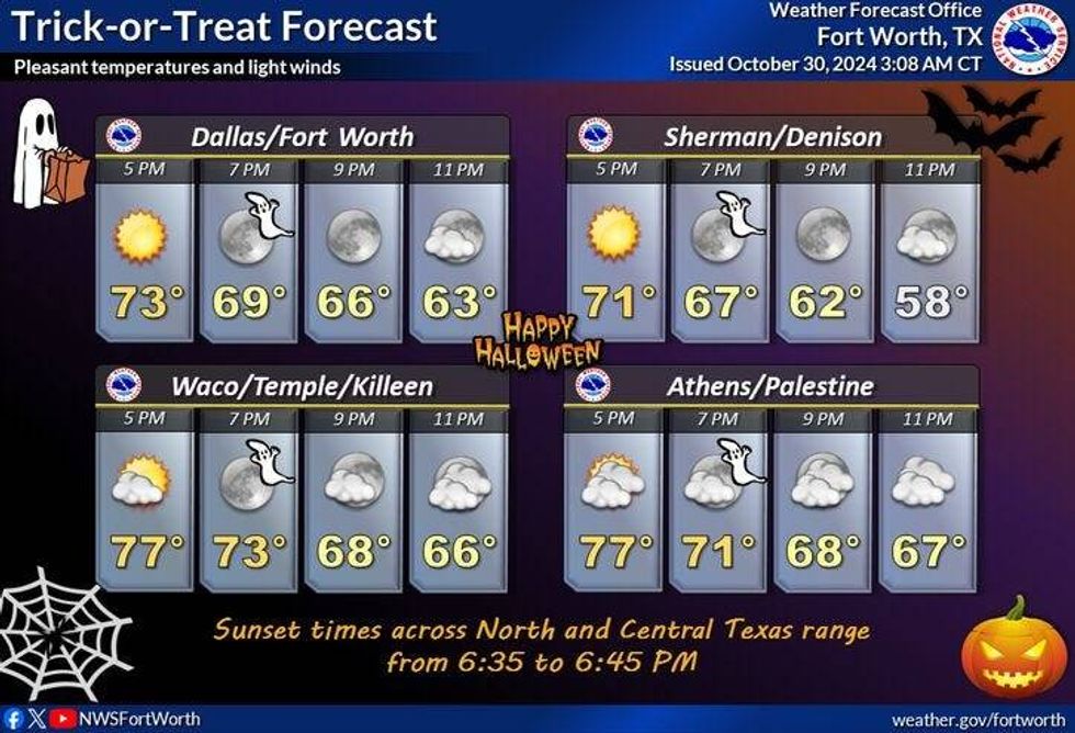 North Texas forecast for Thursday, Oct. 31, 2024.National Weather Service
7-Day Headlines
* DFW Airport reached 86 on Tuesday.
* A few showers on Wednesday, windy and warm.
* Overnight there will be a thin line of storms. Ending early Thursday morning.
* Small hail and gusty wind are the threats.
* Cooler Thursday, but still near average.
* Scattered showers and storms late Friday - Monday. Some severe.
* Cooler and drier sometime Tuesday.
_____________________________________________________
*Tuesday Rain: 0.00"; Tuesday High: 86; Low: 74
*Wednesday's Averages: High: 73; Low: 52
*Record high: 90 (1951); Record low: 24 (1917)
________________________________________________________
*October Rain: Trace; Deficit:
*2024 Rain: 33.94"; Surplus: 2.58"
*Sunrise: 7:45am; Sunset: 6:38pm
________________________________________________________
Today: Morning showers and clouds, partly cloudy this afternoon with a few showers. Windy, muggy and warm. High: Low to mid 80s. Wind: South 15-25, G35 mph.
Tonight: Cold front arrives. Scattered showers and storms. Isolated severe. THREATS: Isolated hail and damaging wind. Low: 55-72. Wind: Shifting west 15-25 mph.
Tomorrow: Morning showers SE, then clearing, breezy and cooler. Lower humidity. High: Low to mid 70s. Wind: North 10-20 mph.
Friday: Increasing clouds and seasonable. Warm front brings scattered rain by evening. High: Upper 70s.
Weekend: Mostly cloudy, scattered showers and storms. Highs: Mid to upper 70s.
Monday: Mostly cloudy, scattered showers and storms. High: Mid to upper 70s.
Tuesday: Clearing, windy and cooler. High: Mid 60s.
LISTEN on the Audacy App
Tell your Smart Speaker to "PLAY 1080 KRLD"
Sign Up to receive our KRLD Insider Newsletter for more news
Follow us on Facebook | Twitter | Instagram | YouTube


