


Arctic blast number two will arrive early Saturday morning and it will stay cold through the middle of next week. There is a chance for more wintry precipitation next week, although numerous factors must come together across North Texas to produce winter weather.
Wednesday began with chilly temperatures again. They fell into the upper 20s to low 30s under a clear sky. Tuesday, North Texas topped out at 56 degrees. Wednesday, we expect to reach the upper 50s once again, which is right at average for this time of year. There will be a quick warm-up on Thursday and Friday as high clouds invade the area.
A south wind will slowly pick up Thursday, and winds will gust up to 30 mph on Friday. This will allow temperatures to warm up significantly, with lows in the 60s on Thursday and mid-to-upper 60s on Friday.
An Arctic blast will come through as cold air oozes into the area on Saturday.
Temperatures shortly after midnight will be in the low 60s, rapidly falling into the 40s by late morning. These temperatures will level off in the mid-40s, with plenty of sunshine and a north wind gusting to 30 mph. This will put wind chills in the 30s all day long.
The cold air will continue to filter in on Sunday. There could be a few flurries northwest of DFW through 12 p.m., with temperatures tumbling into the mid-20s. Sunshine will return by afternoon, with highs in the mid-30s. Wind chills will be in the 20s all day long.
Monday morning will start off sunny with low temperatures falling into the teens. Wind chills will be in the single digits in some areas, making it pipe-bursting weather. Clouds will increase through the day on Monday, with afternoon highs back into the mid-30s. Wind chills will be in the 20s all day.
Late Monday and into Tuesday, I'll be keeping an eye on the track of the next upper-level disturbance overrunning this colder air at the surface. The data is still all over the place regarding the track, speed and strength of the system. The column of air would support all snow, but the air will be very dry, so if we do see precipitation across North Texas, it looks to be light as of now.
Current data suggests the best chance for this to happen will be to the south of the Dallas-Fort Worth area, across Central and Southeast Texas.
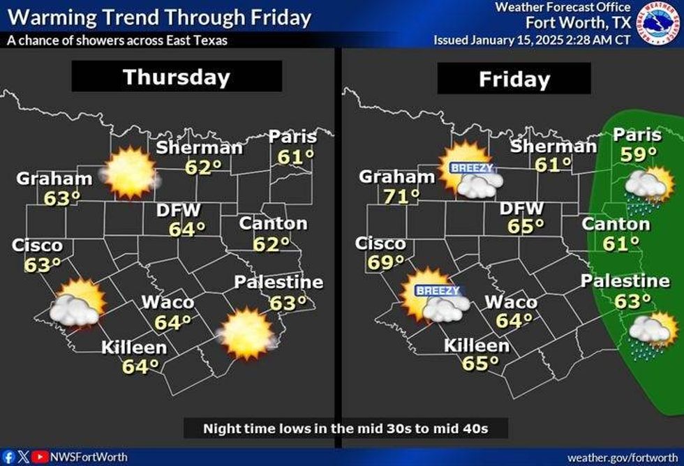 North Texas temperatures for Thursday and Friday, Jan. 16-17, 2025.National Weather Service
7-Day Headlines
* DFW Airport reached 56 on Tuesday.
* A seasonable day on Wednesday.
* A quick warm-up on Thursday and Friday.
* Another Arctic cold front arrives early Saturday morning. Showers east of DFW.
* Windy and very cold this weekend.
* Staying very cold early next week.
* Watching for wintry precipitation late Monday through midweek.
_____________________________________________________
*Tuesday Rain: 0.00"; Yest High: 56; Low: 29
*Wednesday's Averages: High: 56; Low: 36
*Record high: 81 (2020); Record low: 11 (1905, 1924)
________________________________________________________
*January Rain: 1.56"; Surplus: 0.37"
*2025 Rain: 1.56; Snow: 2.30"; Surplus: 0.37"
*Sunrise: 7:31am; Sunset: 5:45pm
________________________________________________________
Wednesday: Partly cloudy and seasonable. High: Mid-50s. North 5 mph.
Wednesday night: Clear and cold. A light freeze away from town. Low: 28-33. Wind: West 5 mph.
Thursday: Partly cloudy and cool. High: Low 60s. Wind: West 5 mph.
Friday: High clouds, windy, and mild. A slight chance of rain late, mainly east of DFW. High Mid 60s.
Saturday: Early morning showers, Dallas to the east, then turning windy and much colder. High: Low 60s early, falling temperatures through the 40s in the morning, 30s by evening. Wind chills below freezing.
Sunday: Morning clouds (flurries?), afternoon sun, Windy and cold. High: Mid 30s.
Monday: Increasing clouds, windy and cold. Watching the potential for wintry precip late. High: Mid 30s.
Tuesday: Cloudy and cold. Watching the potential for wintry precipitation. High: Upper 20s.
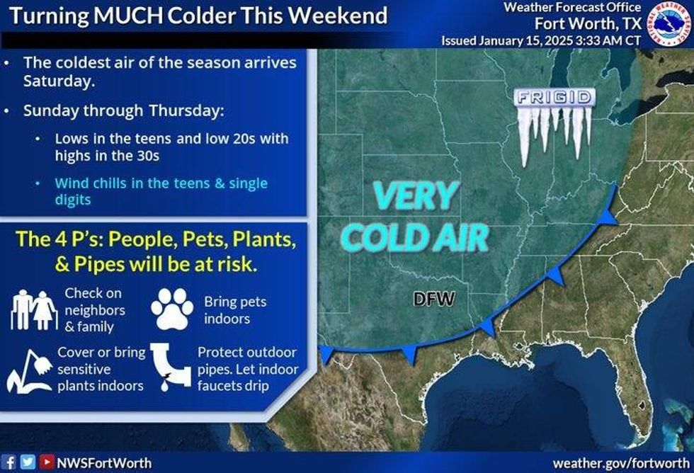 Cold air arrives Saturday in North Texas.National Weather Service
LISTEN on the Audacy App
Tell your Smart Speaker to "PLAY 1080 KRLD"
Sign Up to receive our KRLD Insider Newsletter for more news
Follow us on Facebook | Twitter | Instagram | YouTube


