


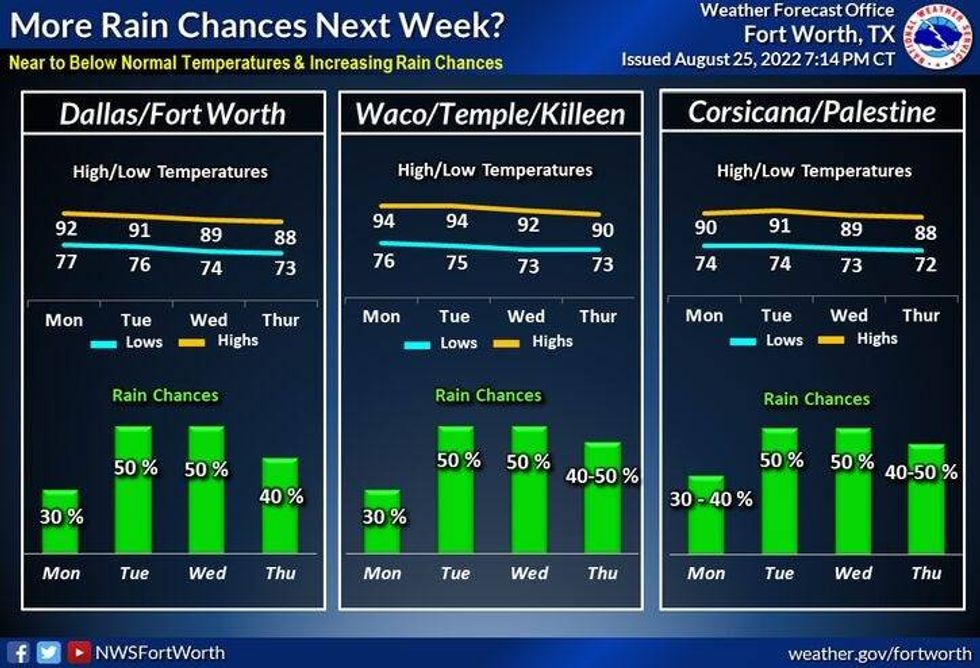
Our decent weather pattern will continue today through Monday with afternoon highs in the low 90s. Morning lows in the mid-70s. There's also a slight chance for an afternoon or evening storm tomorrow, Sunday and Monday, but most stay dry.
Days five, six and seven are always subject to change in a 7-Day forecast. Right now I'm going for more widespread shower and thunderstorm activity on Tuesday and Wednesday and slightly cooler temperatures with highs in the mid to upper 80s.
As of now, it looks like it'll dry out by next Thursday, with highs in the mid to upper 80s again. Some extended data keeps us dry through the period, other data keeps us wet...so check back on Monday for a more accurate forecast.
 National Weather Service - Fort Worth
I do want to take a minute to talk about the extended- extended model data. After day seven and especially after day 10. You're going to see a lot of media-ologists talk about a hurricane nailing the Texas coast after day 10. Please don't believe any of this. Could it happen? Maybe. Will it happen? Probably not.
There are two areas of concern that the Hurricane Center is monitoring right now. Late August and September is peak hurricane season so this bears watching. The Hurricane Center gives each disturbance a 20% chance of formation over the next 72 hours. I will keep an eye on the one that just entered the Caribbean, but as of now no rapid development is expected.
FACTS:
* We've actually had no hurricanes so far in 2022, with only three named storms, and those were all tropical storms. Danielle is our next name storm on the list.
* This is the quietest start to a hurricane season in over 40 years.
*Yest Rain: 0.00"; *Yest High: 93; Low: 74
*Today's Averages: High: 94; Low: 75
*Record high: 106 (1999, 2011); Record low: 60 (1926)
*August rain: 10.38"; August surplus: 8.73"
*2022 Rain: 22.79"; 2022 deficit: -1.23"
*Sunrise: 6:59am; Sunset: 8:00pm
Today: Partly cloudy, warm and humid. High: Low 90s. Wind: Lt. Var.
Tonight: Clear and muggy. Low: Low to mid 70s. Wind: Lt. Var.
Weekend: Partly cloudy, warm and humid. Isolated afternoon showers and storms. High: Low 90s. Wind: SE 5 mph.
Monday: Partly cloudy and humid. Chance of showers and storms. High: Low 90s.
Tuesday and Wednesday: Mostly cloudy, not as hot. Scattered showers and storms. High: Mid 80s.
Thursday: Mostly sunny and warm. High: Mid 80s.

LISTEN on the Audacy App
Tell your Smart Speaker to "PLAY 1080 KRLD"
Sign Up and Follow NewsRadio 1080 KRLD


