We're waking up to some scattered showers this morning, mainly west of I-35W. These will continue to weaken through the morning.
Today will be partly cloudy and warm with an Air Quality Alert in effect. Afternoon highs will warm to near ninety degrees. Areas west of I-35W have the best chance for late afternoon and evening showers and storms today, isolated to the east of I-35W.
 National Weather Service - Fort Worth
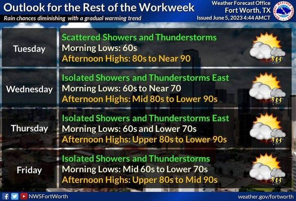
More late day showers and storms are in the forecast on Tuesday, but a lot of you won't see a drop. Afternoon highs will be near ninety degrees.
It will be relatively dry Wednesday through Friday with just a pop up late day storm possible. Afternoon highs will creep up into the low nineties by the end of the week.
Latest data It's showing.a chance of early morning showers and storms on Saturday and Sunday. Temperatures will be heating up with readings in the low to mid nineties.
I hope you see some rain over the next 7 days!
*Yest Rain: 0.00"; Yest High: 88; Low: 66
*Today's Averages: High: 90; Low: 70
*Record high: 102 (1948): Record low: 54 (1970)
*June Rain: 0.00"; Deficit: 0.54"
*2023 Rain: 13.58"; Deficit: 3.55"
*Sunrise: 6:20am; Sunset: 8:34pm
Today: *Air Quality Alert* Morning showers, then scattered afternoon and evening showers and storms. Best chance west of I-35W. Partly cloudy, hazy and warm. High: Upper 80s. Wind: SSE 5-10 mph.
Tonight: Partly cloudy and mild. Low: Mid to upper 60s. Wind: Lt. Var.
Tuesday - Thursday: Partly cloudy and warm. Isolated late afternoon and early evening showers and storms. High: Near 90.
Friday: Partly cloudy and warm. Scattered late evening showers and storms. High: Low 90s.
Weekend: Partly cloudy and a bit warmer. Scattered late evening showers and storms. High: Low to mid 90s.

LISTEN on the Audacy App
Tell your Smart Speaker to "PLAY 1080 KRLD"
Sign Up and Follow NewsRadio 1080 KRLD