The National Weather Service has issued a Heat Advisory for northeast and north central Texas until 8 p.m. Thursday. Temperatures are expected to hit between 103 and 106 and Heat index values up to 107. The National Weather Service urges precaution as there is a high risk of heat-related illness.
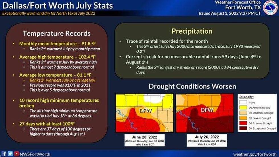
We hit 101° yesterday at DFW marking the 37th time we've hit the triple digits this year. We're also at day 59 with consecutive days with no measurable rain. That ranks number two on the all time list. 84 days is a record set back in the year 2000.
What's causing these extremely hot temperatures and very dry conditions? La Niña is the biggest player, but also we get these upper level ridges of high pressure overhead this time of the year. The center of this ridge has been over the Rocky Mountains over the past several days. This upper level ridge has now shifted into the central plains states and will nose its way into north Texas tomorrow and Thursday. Those will be our two hottest days. This ridge will back away from us a little bit into the weekend, giving us slightly cooler temperatures and a very slight chance for a shower storm on Friday and Saturday. The best chances will be east and south of the Dallas/Fort Worth area.
103° today, 105° both tomorrow and Thursday, 101° on Friday and 102° this weekend leading into early next week.
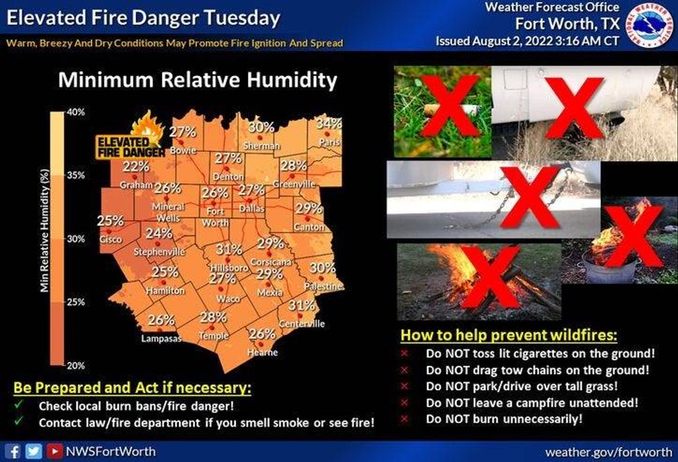
With our dry conditions, hot temperatures, low relative humidity along with a gusty southerly wind, our high grass fire danger will continue for the foreseeable future. The latest Wildfire Outlook through November has come out. Now this is a trend, but it has Texas in this critical danger for the foreseeable future.
 National Weather Service
It usually takes a flood to break your drought.. This being said, we need a weak tropical storm to slowly drift into Texas giving us all some welcome rain. Unfortunately, the tropics are very quiet right now, but typically, August, September into early October is the peak time for hurricane season. I'm hoping we get something "weak" crashing into Texas soon...this is our only hope as it looks right now... Time will tell.
*Yest Rain: 0.00; *Yest High: 101; Low: 83
*Today's Averages: High: 97; Low: 77
*Record high: 110 (2011); Record low: 62 (1965)
*August rain: 0.00"; August deficit: 0.05"
*2022 Rain: 12.41"; 2021 deficit: 10.01"
*Sunrise: 6:43am; Sunset: 8:26pm
 National Weather Service -
Today: Sunny, breezy and hot. HIgh Grass fire danger. High: 103. Wind: South 10-20 mph.
Tonight: Clear and warm. Low: Low 80s. Wind: South 10-20 mph.
Tomorrow: Sunny, windy and hot. High grass fire danger. High: 102-105. Wind: South 15-25 mph.
Thursday: Sunny, breezy and hot. Grass fire danger. High: 102-105.
Friday: Partly cloudy and hot. An isolated shower of storm. High: 101.
Weekend: Mostly sunny and hot. Highs: 99-102.
Monday: Sunny and hot. High: 100-103.
LISTEN on the Audacy App
Sign Up and Follow NewsRadio 1080 KRLD