Daniel Brounoff
5:16 AM (19 minutes ago)
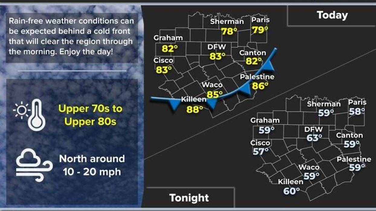
Tuesday, May 20, 2025 Forecast:
Some of you were rocked out of bed across Tarrant, Dallas, Rockwall, and Hunt counties last night. We experienced wind gusts of up to 60 MPH across parts of the Metroplex. All storms have dissipated, and we are expecting a beautiful day ahead.
The rain has cleared until late Thursday. The cold front I mentioned yesterday will move through the area this morning. Humidity levels will decrease rapidly throughout the afternoon as sunshine returns. Afternoon highs will be slightly below average at 82 degrees. It will be a beautiful day. The rain is gone until late Thursday. A cold front will move through the area this morning, causing humidity levels to drop quickly throughout the afternoon. Afternoon highs will be slightly below average at 82 degrees. It will be a beautiful day.
A cool start is expected tomorrow morning, with patchy fog developing. Morning lows will dip into the upper 50s to low 60s as winds slowly return from the south. Afternoon highs will reach the mid to upper 80s, with a quick warm-up expected.
Our next weather system will arrive late Thursday as a cold front sags south of the area. This, combined with an upper-level disturbance, will produce widespread shower and thunderstorm activity, with a slight chance of severe storms. Afternoon highs will reach the low 90s.
The cold front will lift back to the north of us on Friday, allowing south winds to pick up, humidity to increase, and temperatures to warm. Afternoon highs from Friday through the weekend will reach the low 90s.
By late Sunday, our next cold front will arrive, bringing widespread shower and thunderstorm activity by late afternoon and evening. However, most of the day will be okay. Shower and thunderstorm chances may continue into Memorial Day as a trailing upper-level low impacts our weather. Temperatures will struggle to get out of the low to mid 70s. At least most of the holiday weekend will be good.
Have a terrific day today and enjoy the weather when you can, it's the only weather you've got!
7-Day Headlines:
DFW hit 85 degrees on Sunday. 0.22" of rain fell at DFW.Quiet Tuesday and Wednesday.Storms return late Thursday. Some severe.Threats: Large hail, damaging wind, isolated tornadoes.Heating up Friday – Sunday.Storms return late Sunday into Memorial Day. Cooler on Monday.
*Yest Rain: 0.22"; Yest High: 85 Low: 68
*Today's Averages: High: 85; Low: 66
*Record high: 98 (1922): Record low: 48 (1981)
*May Rain: 2.09"; Deficit: 0.65"
*2025 Rain: 16.24"; Surplus: 1.47"
*Sunrise: 6:25am; Sunset: 8:25pm
Tuesday: Morning clouds and dry cold front, afternoon sun. Breezy and cooler. High: Low 80s. Wind: NW 10-20 mph.
Tuesday night: Clear and cool. Patchy fog. Low: 57-62. Wind: Lt. Variable.
Wednesday: Sunny and warm. Low humidity. High: Upper 80s.
Thursday: Partly cloudy. Increasing humidity. Stalling front near north Texas. Scattered storms, some severe by evening. High: Upper 80s.
Friday: morning clouds, afternoon sun. Breezy and warm. High: Low 90s.
Weekend: Partly cloudy, warm and humid. Storm threat increases late Sunday. Highs: Low 90s.
Memorial Day. Mostly cloudy, scattered showers and storms. MUCH cooler. High: Mid 70s.
LISTEN on the Audacy App
Tell your Smart Speaker to "PLAY 1080 KRLD"
Sign Up to receive our KRLD Insider Newsletter for more news
Follow us on Facebook | Twitter | Instagram | YouTube