Just set aside your umbrellas for now, as a significant amount of rainfall is expected to hit North Texas starting tomorrow morning and persist through at least Saturday afternoon. Fortunately, the severity of the weather will remain low, allowing us to make a substantial dent in our rainfall deficit.
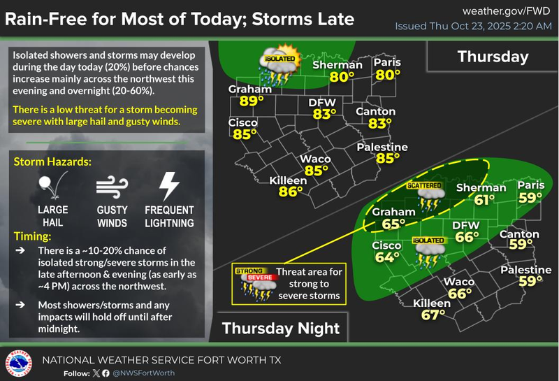
Good morning, everyone. Welcome to Thursday. Your commute to work or school should be uneventful this morning, with clear radar and temperatures mainly in the 50s, which is not as cool as yesterday morning at this time. Today will bring plenty of sunshine, with increasing cloud cover later in the day. Afternoon highs will reach the low 80s, exceeding our average temperature of 76 degrees for this date.
Tomorrow morning, you can expect to wake up to rain on your windshield, so be sure to allow for extra time to reach your destinations. We may even experience a rumble of thunder through mid-morning. The initial batch of rain should clear out before the new hour, with temperatures warming up to the upper 70s.
By Friday evening, a large area of rain accompanied by thunder and wind will approach from the west after dinner time. This system will gradually move through our area while we sleep on Saturday morning. Most areas can expect to receive an inch or two of much-needed rain, with severity remaining very low. This is certainly good news all around. I always appreciate it when it rains while I'm sleeping.
The first wave of rain will shift east of us by late morning, but another area of showers and storms may develop in our southwest and creep in during the afternoon and early evening hours. The best chance for the heaviest rain will remain south of Interstate 20, shifting into East Texas. Afternoon highs will hold steady in the mid-70s.
Looking ahead to Sunday, the forecast appears fantastic, with sunshine returning. We may experience some low clouds or fog early Sunday morning, followed by partly cloudy skies and highs in the mid to upper 70s.
Two cold fronts are expected to impact our weather next week. The first front will arrive on Monday afternoon, with sunny skies and highs near 80 degrees. The second front will arrive on Tuesday, with highs reaching the mid-70s as winds pick up from the north at 15 to 25 miles per hour.
By Wednesday, we can expect a significant cool-down under sunny skies, with very windy and cool conditions and afternoon highs only in the mid-60s.
Enjoy the rest of your day today, and always enjoy the weather when you can, it's the only weather you've got!
7-Day Headlines:
* DFW Airport reached 81 on Wednesday.
* A quiet day today.
* Morning Friday rain. HEAVY rain Friday night into Saturday.
* Isolated severe Friday evening. Wind is the main threat.
* More rain on Saturday, clearing out Sunday.
* MUCH cool next week, starting Tuesday.
*Yest Rain: 0.00"; Yest High: 81 Low: 53
*Today’s Averages: High: 76; Low: 54
*Record high: 91 (1925, 1939); Record low: 36 (1917, 1950)
*October Rain: 0.24"; Deficit:
*2025 Rain: 28.40"; Deficit:
*Sunrise: 7:40am; Sunset: 6:44pm
Thursday: Partly cloudy, breezy and mild. High: Low 80s. Wind: SSE 10-20 mph.
Thursday night: Increasing clouds and mild. Rain after midnight. Wind: SSE 10-20 mph.
Friday: Morning rain, then mostly cloudy and breezy. High: Upper 70s. Wind: SSE 15-25 mph.
Friday night: Cloudy, breezy and wet! Widespread HEAVY rain with thunder. Isolated severe for wind early. Rain totals: 1"-3". High: Low Upper 60s.
Saturday: Morning heavy rain, then scattered showers with thunder during the afternoon. Rain totals < 0.50". Clearing late evening. High: Mid 70s.
Sunday: Mostly sunny by late morning. High: Upper 70s.
Monday: Mostly sunny and nice. Weak cold front late. High: Near 80.
Tuesday: Mostly sunny, breezy, and a tad cooler. High: Mid 70s.
Wednesday: Sunny, windy and even cooler! High: Mid 60s.
LISTEN on the Audacy App
Tell your Smart Speaker to "PLAY 1080 KRLD"
Sign Up to receive our KRLD Insider Newsletter for more news
Follow us on Facebook | Twitter | Instagram | YouTube
