


Welcome to the first official full day of fall, ladies and gentlemen, although it will not feel like it due to the anticipated heat index of over 100 degrees. Fortunately, a strong cold front will move through the area late tonight, bringing cooler temperatures and a threat of strong to isolated severe storms.
Happy Tuesday, ladies and gentlemen. It is a muggy morning with temperatures in the 70s and high humidity. Remember to grab your umbrella if you will be out late this evening, as you will likely need it.
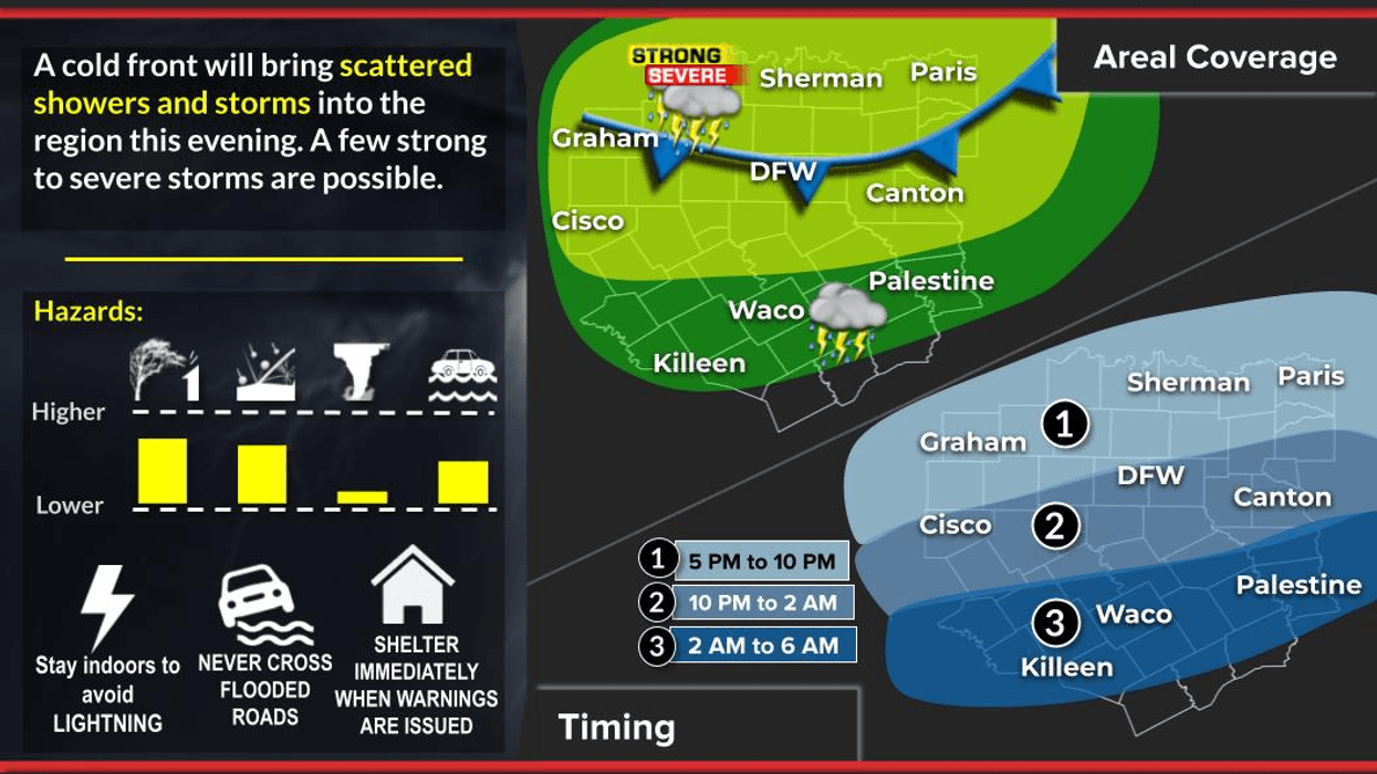
I am tracking a strong cold front that is currently entering the Northern Texas panhandle. This front will take its time reaching us and will slowly move into the area late this evening through early tomorrow morning. Ahead of the front, scattered strong to isolated severe storms will break out to our Northwest late this afternoon and evening. These storms will continue to move through North Texas late this evening through early tomorrow morning. While I cannot rule out one or two warnings for wind and hail, the tornado threat is very low and will be confined to areas including Eastern Oklahoma, Northwest Arkansas, and Southern Missouri. Please stay weather-aware if traveling to these areas this evening. Temperatures today will reach the mid-90s with heat index values as high as 103 degrees.
Unlike typical cold fronts, this one will not take all the rain with it as it heads south of the area. Instead, the disturbance will follow behind the front through noon tomorrow, bringing a large area of rain into North Texas from the West Northwest. While no severe weather is expected for tomorrow morning's commute, it will be a messy time getting to work and school. This batch of rain will slowly move south of the area by late morning into the early afternoon hours. Clouds will stick around for most of the day, keeping afternoon highs in the 70s. It will feel nice.
Rainfall totals will range from half an inch to 3 inches plus across North Texas. While it is too early to determine where the heaviest rain will fall, almost everyone will see some rain out of this system.
Thursday and Friday look great with plenty of sunshine, lower humidity, and afternoon highs in the low 80s on Thursday and low to mid-80s on Friday, which is the opening day of the State Fair of Texas. Morning lows will be in the 50s and 60s. HECK YEAH!
This weekend will be equally nice, but a bit warmer with morning lows in the mid to upper 60s and afternoon highs reaching the mid to upper 80s, which is close to average for this time of year.
I will be keeping an eye on the storms late this evening. Please stay tuned to NewsRadio 1080 KRLD AM for updates as conditions warrant. Have a great day today and enjoy the weather when you can, it's the only weather you've got.
7-Day Headlines:
DFW hit 95 degrees on Monday.
First official full day of Fall!
Stupid hot and humid today. Sorry!
Scattered severe storms tonight. Threats: Hail and wind.
Pockets of flooding rain overnight through noon Wednesday.
Cooler weather on the way.
Beautiful weather Thursday through the weekend.
*Yest Rain: 0.23"; Yest High: 95 Low: 74
*Today's Averages: High: 87; Low: 66
*Record high: 101 (2023); Record low: 44 (1995)
*September Rain: 1.05"; Deficit:
*2025 Rain: 28.10"; Surplus: 1.47"
*Sunrise: 7:18am; Sunset: 7:22pm
Tuesday: Partly cloudy, hot and humid.. High: Mid 90s. Heat index: 103 degrees. Wind: South 10-20 mph.
Tuesday night: Cloudy, turning cooler late. Widespread showers and thunderstorms. A few may become severe. Threats: Hail and damaging wind. Low: 67-75. Wind: North 10-15 mph.
Wednesday: Morning heavy rain with thunder. Isolated flooding in areas. Rain totals: 0.25" to 3.00"+. Slow clearing by evening. High: Mid to upper 70s. Wind: North 10-20SW 5-10 mph.
Thursday: A cool morning, 60s! Mostly sunny and nice. High: Low to mid 80s.
Friday: A cool morning, 60s! Opening day of the State Fair of Texas. Mostly sunny and seasonable. High: Mid to upper 80s.
Weekend: Partly cloudy and warm. High: Upper 80s.
Monday: Partly cloudy, continued warm. High: Near 90.
LISTEN on the Audacy App
Tell your Smart Speaker to "PLAY 1080 KRLD"
Sign Up to receive our KRLD Insider Newsletter for more news
Follow us on Facebook | Twitter | Instagram | YouTube


