Below average temperatures, a big warm up, a lot of wind with a grass fire danger this weekend, and possibly some rain by next Tuesday along with cooler temperatures. Those are your weather stories over the next 7 days.
Tepmeratures have fallen into the mid 30s to low 40s across north Texas. The record low for this morning is 38° at DFW airport. As of 6:00 a.m., the temperature is 45° at the airport. We still have a ways to go to break the record. As of now, I don't think we'll break it however, reading's have fallen to near freezing north and east of DFW.
High pressure at the surface will slowly drift to the east today and southerly a wind will return. That means a warming trend will rapidly unfold.. it'll still be cool today, afternoon highs will reach the upper 60s under a clear sky.
Clear skies tonight and a light wind will allow the temperatures to fall well down into the 40s again. There will be some upper 30s to the east of DFW. A south wind will blow from 5 to 10 mph.
 National Weather Service - Fort Worth
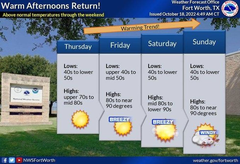
Southwesterly winds will grip the area Thursday through Saturday. This will allow temperatures to warm up. Plenty of sunshine will dominate the area through the weekend with afternoon highs in the low 80s on Thursday, pushing 90° Friday through Sunday with a high grass fire danger this weekend. SSW winds will gust as high as 35 mph. Please keep this in the back of your mind.
Monday of next week, humidity levels will increase and the wind will relax a little bit. However, temperatures will still reach the upper 80s.
By late Monday into Tuesday morning Tuesday, a chance for showers and thunderstorms may return with highs in the mid 70s on Tuesday. Clearing and cooler weather for the middle to end of next week.
*Yest Rain: 0.00"; High: 74; Low: 48
*Today's Averages: High: 77; Low: 56
*Record high: 94 (1921); Record low: 38 (1989)
*October rain: 0.07"; October deficit: 2.25"
*2022 Rain: 23.49"; 2022 deficit: 6.10"
*Sunrise: 7:35am; Sunset: 6:50pm
Today: Clear and cool. High: Mid to upper 60s. Wind: South 5 mph.
Tonight: Clear and chilly again. Protect plants. Bring pets indoors. Low: 40-45. Wind: South 5-10 mph.
Thursday: Sunny and warmer. High: Low 80s. Wind: WSW 5-10 mph.
Friday: Sunny, breezy and very warm. High: Upper 80s.
Weekend: Mostly sunny, windy and warm. Grass fire danger. Highs: Near 90.
Monday. Partly cloudy, warm and humid. Slight chance for showers and storms by late evening. High: Mid to upper 80s.
Tuesday: Slight chance for showers and storms early, then decreasing cloudy and cooler. High: Upper 70s.

LISTEN on the Audacy App
Sign Up and Follow NewsRadio 1080 KRLD